 Mon GéoSource
300000
Type of resources
Available actions
Topics
INSPIRE themes
Keywords
Contact for the resource
Provided by
Years
Formats
Representation types
Update frequencies
status
Scale
-

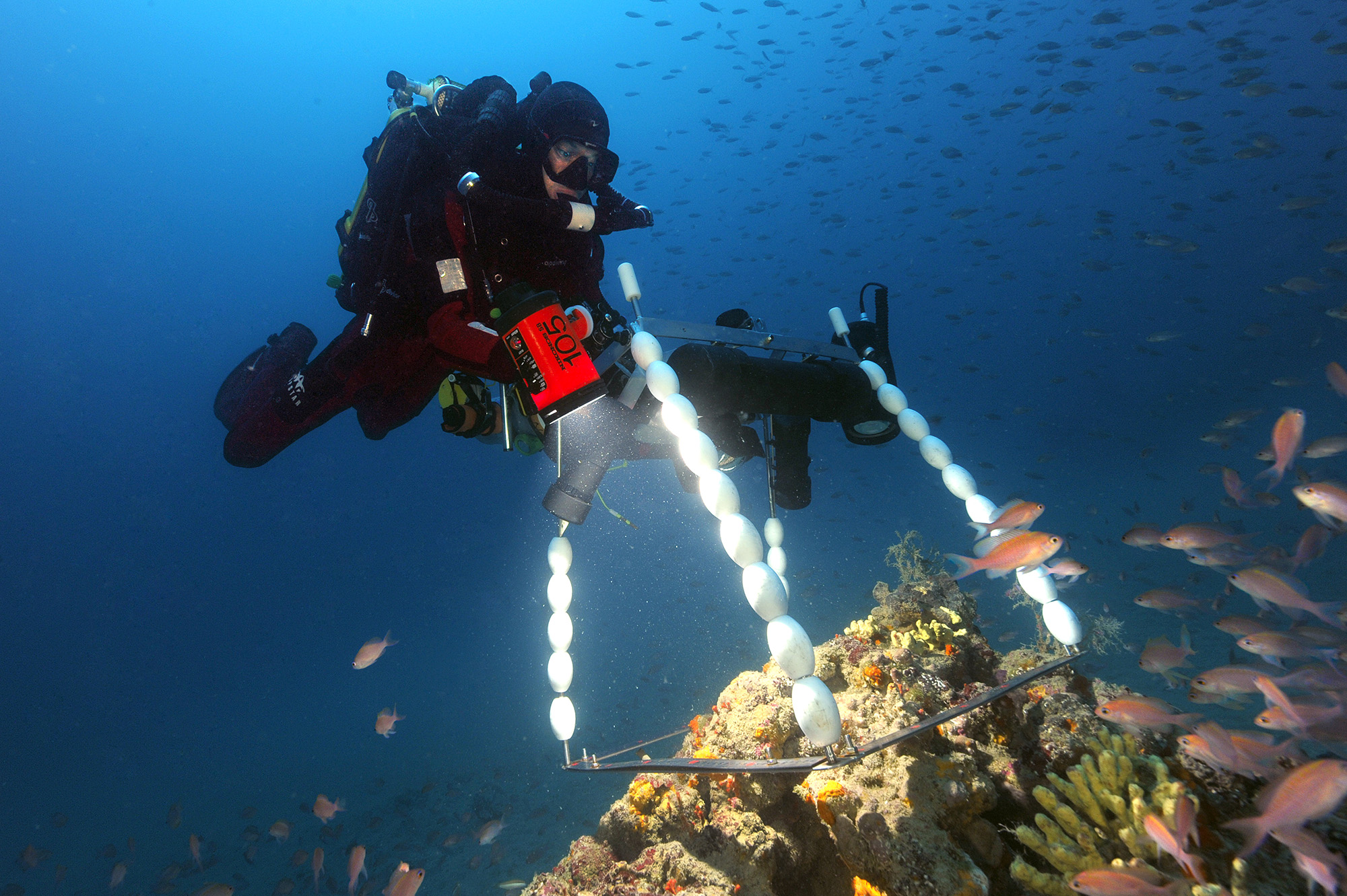
Bathymetry around Saint-Paul and Amsterdam Islands: the Digital Terrain Model is the result of data compilation of multibeam surveys from 1984 to 2019. Grid resolution is 150 m. The DTM was processed as part of the French national program (EXTRAPLAC) for the delineation of the outer limit of the continental shelf beyond 200 nautical miles, and in collaboration between Ifremer and the Western Brittany University (UBO Brest). - MD157/ PLURIEL: 2006, R/V Marion Dufresne, SMF Seafalcon, https://doi.org/10.17600/6200130 - BOOMRANG-Leg6: 1996, R/V Melville, https://calisphere.org/item/ark:/20775/bb9424302r/ The datasets from the following cruises have been also integrated: - MD171/ GEISEIR1: 2009, R/V Marion Dufresne, SMF Seafalcon, https://doi.org/10.17600/9200050 - MD120/ ANTAUS: 2000, R/V Marion Dufresne, SMF Seafalcon, https://doi.org/10.17600/200090 - MD118/ DEFLO: 2000, R/V Marion Dufresne, SMF Seafalcon, https://doi.org/10.17600/200070 - MD106/ IPHIS: 1997, R/V Marion Dufresne, SMF Seafalcon, https://doi.org/10.17600/97200010 - HYDROAMSTERDAM: 1984, R/V Jean Charcot, https://doi.org/10.17600/84000111 - NBP0406: 2004, R/V Nathaniel B. Palmer, DOI 10.7284/905502 - MD197/ MYCTO: 2014, R/V Marion Dufresne, SMF Seafalcon, https://doi.org/10.17600/14002500 - MD211/ OBSAUSTRAL: 2018, R/V Marion Dufresne, EM122, https://doi.org/10.17600/18000490 - MD217/ OBSAUSTRAL: 2019, R/V Marion Dufresne, EM122, https://doi.org/10.17600/18000885 - TN362 (Coring to Reconstruct Ocean Circulation and Carbon-dioxide Across 2 Seas: CROCCA-2s), R/V Thomas G. Thompson, 2018. 10.7284/908704
-
-
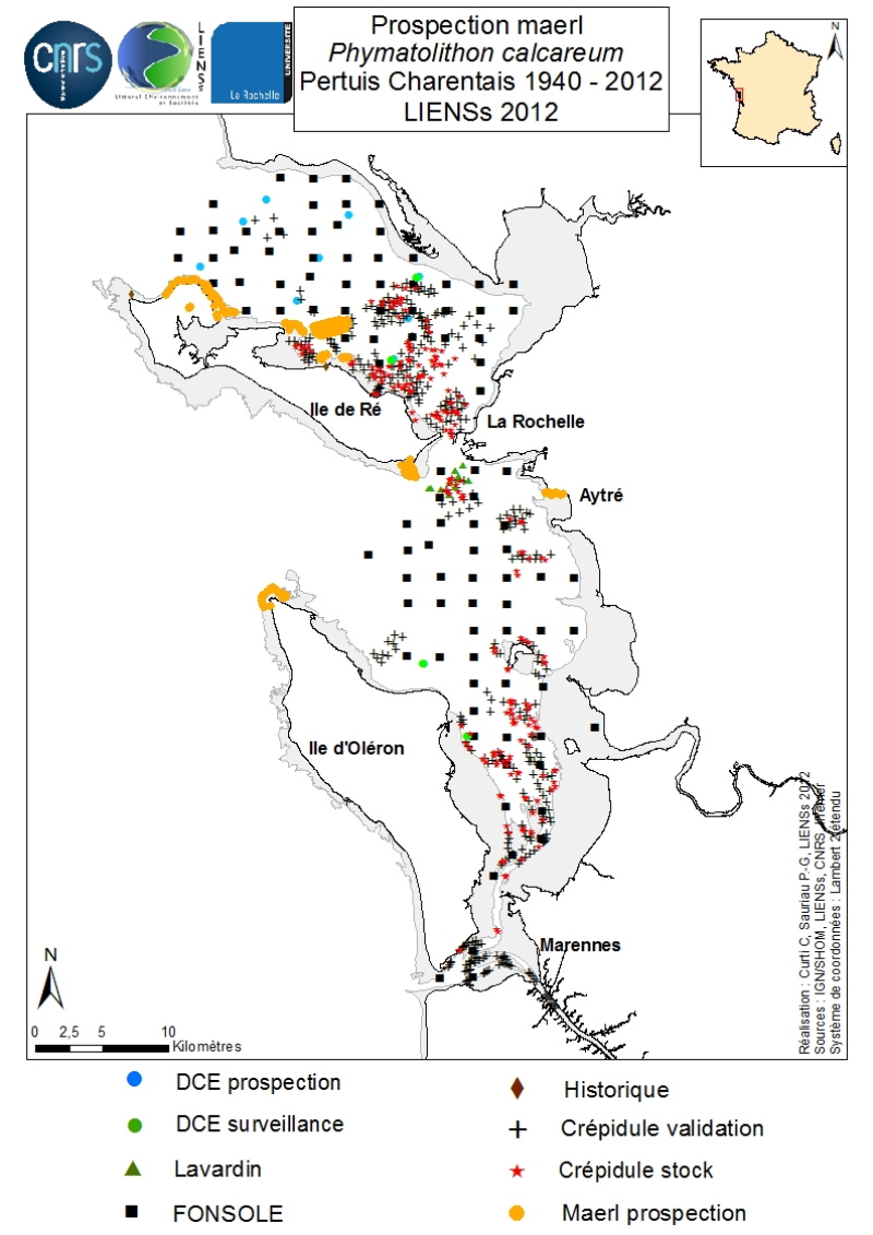
An inventory of mäerl ( unfixed red marine algae Corallinaceae with calcified arbuscular thalli) is taken in the Pertuis Charentais using the compilation of historical data and new observations over the period 2006-2012. The geographic extent of the inventory includes Pertuis Breton, Antioch and Maumusson, extends from the Lay estuary in the north to the Bay of Marennes-Oléron in the south and includes the edges of the islands of Ré, Oléron and Aix. Contributing to this inventory are, surveys DCE 2006 DCE, control monitoring DCE 2007 to 2012 under the aegis of Ifremer and Agences de l’Eau Loire-Bretagne and Adour-Garonne, surveys conducted for the Port Atlantique La Rochelle on the site of dredge spoil deposits in Lavardin from 2007 to 2012, surveys in 2007 FONSOLE by Ifremer and the surveys by Ifremer and laboratory LIENSs to map the crepidula stocks in the Pertuis Charentais Sea. Adding specific surveys conducted in 2011 by the ship Estran by dredge on subtidal bottom sediments of Pertuis Breton and intertidal quadrat in 2012 on the periphery of the islands of Ré, Oléron and along the cliffs of Aytré. The positioning of ground truthing stations were identified by GPS or dGPS. Initially identified by samples of the dredged material in October 2009 during the validation of sonar surveys to individualize stocks of crepidula, a live maerl bed is mapped in July 2011 in the harbor of Saint-Martin in Pertuis Breton. Its area is estimated at more than 2 km². Surveys of pedibus jambi conducted at the point of Grouin and Saint-Martin de Ré has confirmed the presence of live maerl scattered on the lower foreshore. This suggests a scattering of live maerl thalli of several tens of km² around the main bed of Saint-Martin. It is also confirmed by the single algological extraction of Phymatolithon calcareum done at the beginning of the twentieth century in Saint-Martin de Ré by Dollfus, probably already on the lower foreshore as observed in 2012 near the Couronneau beacon. Numerous dead maerl thalli in the procress of diagenesis have also been observed in the East and Southeast of Pertuis Breton and Antioch suggesting passive transport by contributions from live beds farther to the West, including Pertuis in Antioch. The presence of live maerl on the lower foreshore is seen very occasionally in the western islands of Oléron (Pointe Chassiron) and Ré (Phare des Baleines) via recent algologiques and fauna surveys. In biogeographic terms, the maerl bed of Pertuis Breton is the easternmost and southernmost of those known in the Bay of Biscay. The nearest mäerl beds known are respectively located in Noirmoutier (Bourgneuf Bay) and Galicia (Spain). These observations complement the atlas mapping of maerl populations in Europe published under the auspices of the OSPAR Convention. They provide a knowledge base for future conservation actions defined locally in the context of Natura 2000 Sea Marine Natural Park of the Gironde estuary and the Pertuis Charentais.
-
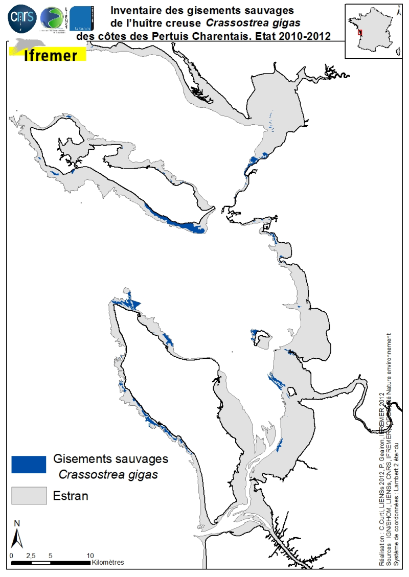
The geographical distribution of the main sources of wild Pacific oysters (Crassostrea gigas) (Thunberg, 1793) on the coasts of the Pertuis Charentais was compiled from 2010 to 2012. The inventory focuses on natural foreshore deposits (+ 6-0 m sea coast) and compiles two cartographic sources: 1) quantitative inventories made in 2010 by Ifremer from the Tranche sur Mer (Vendée) to Vaux-sur-Mer in 21 representative sites to estimate wild stocks of Pacific oysters and 2) inventory mapping of intertidal marine habitats mainly made by LIENSs (in cooperation with CREOCEAN, IODDE, Ré Nature Environnement and GEO-Transfert) under the project CARTHAM Natura 2000at sea of the Agency of Marine Protected Areas. Methodologies used by Ifremer to estimate the areas colonized combine thematic analysis in Geographic Information System (GIS) and field validations (Soletchnik et al., 2012). The methodologies used to estimate LIENSs extension of the intertidal habitat of the oysters combined aerial image analysis, remote sensing, field validations and thematic analysis using GIS (Cajeri et al., 2012).
-
-
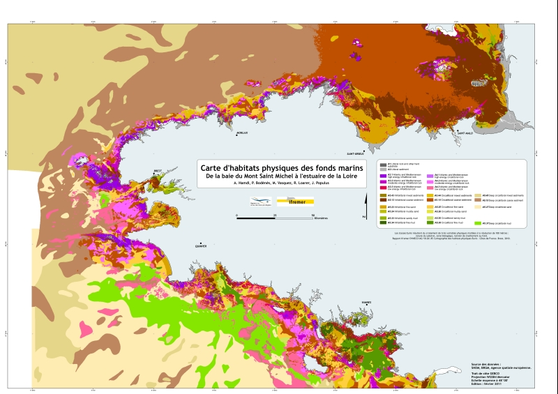
Eunis-classified physical habitats physiques resulting from the combination of three physical variables meshed at a resolution of 100 metres: nature of the substrates, biological area, shearing tension on the sea floor. Coasts of mainland France. Ifremer report "Hamdi Anouar, Vasquez Mickael, Populus Jacques (2010). Cartographie des habitats physiques Eunis - Côtes de France. Ifremer/AAMP agreement n° 09/12177764/FY. http://archimer.ifremer.fr/ doc/00026/13751/ "
-

Répartition de la population (valeur 2008 suite au "nouveau recensement") à partir du carroyage de 200m x 200m de l'INSEE, mais réparti plus précisément en fonction de l'occupation des sols. Montpellier Méditerranée Métropole.
-
Couche de points représentant les observations d'habitats vulnérables des fonds meubles des mers celtiques et du Golfe de Gascogne depuis le début du XXème siècle.
-
Cette carte des peuplements benthiques du secteur d'Arcachon a été réalisée d’après la thèse d'Yves Monbet, intitulée " Etude bionomique du plateau continental au large d'Arcachon (application de l'analyse factorielle) ", publiée en 1972. Cette étude sur les fonds chalutables de la côte landaise et girondine au large d’Arcachon a permis d’identifier 5 aires sédimentaires disposées parallèlement à la côte. Les peuplements benthiques sont répartis en 2 grands ensembles, l’ensemble côtier composé de 3 peuplements et l’ensemble subcôtier de 4 peuplements. La carte a été numérisée en 2005 et une harmonisation avec la typologie EUNIS a été effectuée en 2007 (projet REBENT).
-
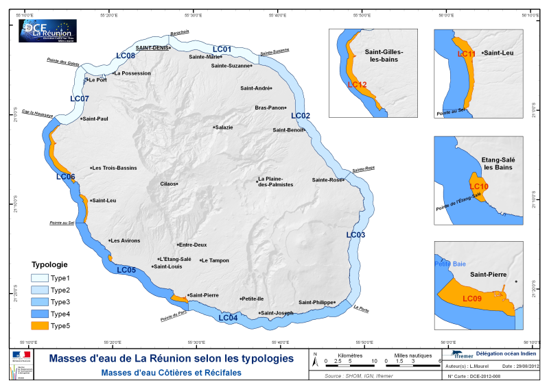
Délimitation des masses d'eau littorales au titre de la DCE sur le bassin de La Réunion. Une masse d'eau côtière est une partie distincte et significative des eaux de surface situées entre la ligne de base servant pour la mesure de la largeur des eaux territoriales et une distance d’un mille marin. Correspondance rapportage DCE : cette entité correspond au concept de Coastal Water Body (CWBODY) de WISE. Elle permet de définir les objectifs environnementaux, d’évaluer l’état des milieux et ultérieurement de vérifier l’atteinte de ces objectifs. La version diffusée sur le site du SANDRE est conforme au rapportage de 2016 . La prochaine version du référentiel Masse d’eau (masses d’eau provisoires, définies pour l’Etat des Lieux) est prévu pour 2019. Les couches sont diffusées dans un format conforme au dictionnaire de données SANDRE du Référentiel masse d’eau, version 1.3.