 Mon GéoSource
/Milieu physique/Géologie sédimentologie/Géologie
Type of resources
Available actions
INSPIRE themes
Provided by
Years
Formats
Representation types
Scale
-
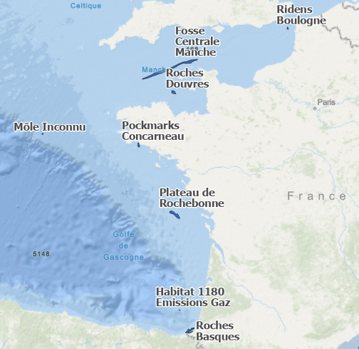
Contours des structures géologiques particulières dans la Manche et le golfe de Gascogne (BESSON Florian, 2019). Le recensement de ces structures est effectué pour les besoins de la Directive Cadre Stratégie pour le Milieu Marin (DCSMM), descripteur D1-Biodiversité des habitats benthiques profonds. Campagnes océanographiques à l'origine de cette donnée : - BOURILLET Jean-François (2009) BOBGEO cruise, RV Pourquoi pas ?, https://doi.org/10.17600/9030060 - EHRHOLD Axel, RIBOULOT Vincent (2018) SYPOCO 2018 cruise, RV Thalia, https://doi.org/10.17600/18000420 Références bibliographiques : - EMODnet Bathymetry, 2018 - AUGRIS C. et al.(1999). Carte des formations superficielles du domaine marin côtier du pays basque (Pyrénées Atlantique) (données vecteurs). Ifremer - Géosciences Marines. http://doi.org/10.12770/e2afa530-7170-11dc-b1e4-000086f6a62e - CIRAC P. et al. (2016). Carte des formations superficielles du plateau aquitain (2016). EPOC-Université de Bordeaux - Ifremer-Géosciences Marines. http://dx.doi.org/10.12770/602a30c5-c338-4e75-a591-baccb8ba1f79 - DUPRE S. et al. (2014). Fluid emissions at the Aquitaine Shelf (Bay of Biscay, France): A biogenic origin or the expression of hydrocarbon leakage? https://doi.org/10.1016/j.csr.2014.07.004 - Cartes hydrographiques du SHOM
-
Acoustic water column data acquired in 2009 during the MARMESONET marine expedition led to establish an accurate spatial distribution of gas emissions on the scale of the Sea of Marmara. The present database is composed of a surface shape file (.shp) dedicated to GIS applications. This seafloor surface represents the insonified area within which gas emissions occurred for more than 1 month of survey, from 4 November 2009 to 14 December 2009; as displayed in Figure 4 of Dupré et al. 2015 (Dupré S, Scalabrin C, Grall C, Augustin AH, Henry P, Sengör AMC, Görür N, Çagatay N, Géli L (2015) Tectonic and sedimentary controls for widespread gas emissions in the Sea of Marmara. Results from systematic, shipborne multibeam echosounder water column imageries. Journal of Geophysical Research 120 (5):2891-2912. doi:10.1002/2014JB011617). This publication investigated and discussed the relationship between fluid emissions at the seafloor with the fault network (active and inactive faults) and the sedimentary environment (nature, thickness and related-processes).