 Mon GéoSource
2018
Type of resources
Available actions
Topics
INSPIRE themes
Keywords
Contact for the resource
Provided by
Years
Formats
Representation types
Update frequencies
status
Service types
Scale
Resolution
-
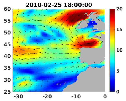
Wind analyses, estimated over the North Atlantic Ocean with a focus on some specific regions, are one the main ARCWIND (http://www.arcwind.eu/) project deliverables. They are estimated from various remotely sensed wind observations in combination with numerical model (WRF), with regular space (0.25deg in latitude and longitude), and time (00h:00, 06h:00, 12h:00, 18h:00 UTC), and based the method described in (Bentamy A., A. Mouche, A. Grouazel, A. Moujane, M. A. Ahmed. (2019): Using sentinel-1A SAR wind retrievals for enhancing scatterometer and radiometer regional wind analyses . International Journal Of Remote Sensing , 40(3), 1120-1147 . https://doi.org/10.1080/01431161.2018.1524174).
-
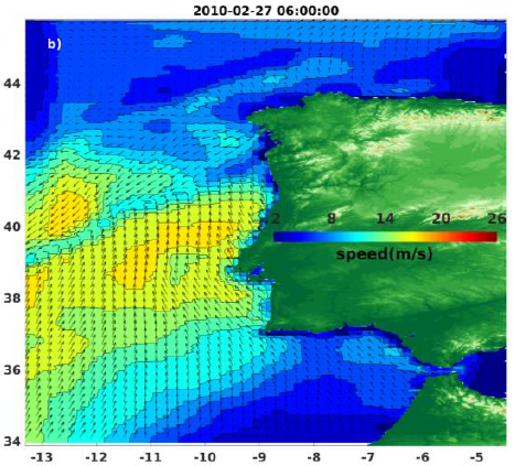
Wind analyses, estimated over the North Atlantic Ocean with a focus on some specific regions, are one the main ARCWIND (http://www.arcwind.eu/) project deliverables. They are estimated from various remotely sensed wind observations in combination with numerical model (WRF), with regular space (0.125deg in latitude and longitude), and time (00h:00, 06h:00, 12h:00, 18h:00 UTC), and based the method described in (Bentamy A., A. Mouche, A. Grouazel, A. Moujane, M. A. Ahmed. (2019): Using sentinel-1A SAR wind retrievals for enhancing scatterometer and radiometer regional wind analyses . International Journal Of Remote Sensing , 40(3), 1120-1147 . https://doi.org/10.1080/01431161.2018.1524174).
-
Service WMS mis en ligne conjointement par les plateformes PPIGE et GéoPicardie sur le territoire de la Région Hauts-de-France.
-

Habitat typology obtained from the statistical analysis of underwater video data collected from the STAVIRO autonomous unbaited video technique (AMBIO project)
-
World list of seaports. In its 2021 version, the repository includes 13709 ports for 187 countries. The list of seaports has been drawn up on the basis of the information available in the European reference system of places used in the framework of the Common Fisheries Policy and, more particularly, by the Electronic Recording and Reporting System (ERS), the list of ports identified by the UNECE (2021-1). An assessment of the infrastructures present along the coastline made it possible to identify other ports that were not listed. Each geographical position has been verified with Google Earth in WGS84. Each port is associated with information relating to the country (ISO 3 coding), the UNECE or ERS 5-character coding, the name, the geographical position in WGS84 (latitude and longitude), the status of the port indicating whether it is referenced by Unece (UNECE), by the EU/ERS (ERS) or by both (UNECE/ERS) In case the port is not referenced by UNECE or ERS, the status is N/A. For French ports, the reference system integrates the ports of the French overseas departments and territories with the national codification. Inland ports have also been integrated in 2021.
-
Cartographie des fréquences d'observation des différentes espèces de cétacés autour de l'île de La Réunion en 2018 selon une grille de maille 2kmx2km.
-
Densité par groupe trophique et par station : nombre d’individus dans un rayon de 5 m autour du système STAVIRO, rapporté à une surface de 100 m². L’appartenance à un groupe trophique est déterminée à l’aide du référentiel des espèces du projet PAMPA (Gamp et al. 2013), et mis à jour pendant le projet AMBIO.
-

Bathymétrie de l'anse de la Mondrée au pas de 1 mètre (WGS84, projection de Mercator 49,5°N) réalisé à partir des données de sonar interférométrique. Traitement Caraibes 4.3 / Delphine PIERRE (GM-CTDI) : rapport "BIEROC - Traitement bathymétrie. DIT.REM/GM/CTDI 20150113-DP01".
-
Dans le cadre de la mise en œuvre du plan d’actions pour les milieux marins, le Cerema eau, mer et fleuves, a réalisé pour le Ministère chargé de l'environnement, une étude nationale en France métropolitaine permettant de recenser le niveau d'équipement en aires de carénage des ports de plaisance, des zones de mouillage et des chantiers nautiques privés afin d'évaluer leur respect à l'environnement. Les données collectées pour le département [nom du département] ont permis de construire une couche d'information géographique. Cette dernière localise sur ce département, sous forme de points, les sites (ports de plaisance, zones de mouillages et chantiers nautiques privés) équipés ou non en aires de carénages. La couche caractérise également le niveau d'équipement en aires de carénage de chacun des sites recensés et, pour ceux équipés d'une aire de carénage, le type de traitement des effluents.
-

In order to manage coastal monitoring data, Ifremer has developed the Quadrige information system which connects a database to a wide array of tools for interpreting and designing information products. Quadrige is just one element of the Water Information System (SIE) www.eaufrance.fr and, as such, contributes toward the work of the French National Adminitrative Service for Water-Related Data (SANDRE) www.sandre.eaufrance.fr. The main aim of the Quadrige thematic databank is to manage and enhance data from coastal observation and monitoring networks. On a national level, Quadrige is today designated by the French Environment Ministry as the definitive information system for coastal waters, and the tool is therefore common to all of those working in the marine environment sector. The Quadrige databank is composed of data from the Quadrige database and products described or made available on the Envlit website. The Quadrige database contains results about most physical, chemical and biological environmental description parameters. The first data for example dates back to 1974 for the parameters relating to general water quality and contaminants, 1987 for phytoplankton and phycotoxins, 1989 for microbiology, from the early 2000s for the benthic zone. The data is permanently being updated. In Quadrige, an observation location is a geographical location where observations, measurements and/or samples will be taken. These locations can be located in a unique way thanks to their appearance on a map (polygon, line or point). A measurement location can be used by multiple programmes.