 Mon GéoSource
200000
Type of resources
Available actions
Topics
INSPIRE themes
Keywords
Provided by
Years
Formats
Representation types
Update frequencies
status
Scale
Resolution
-
Stocks of Crepidula fornicata Linnaeus, 1758 in the Pertuis Charentais. Environmental state for 2011
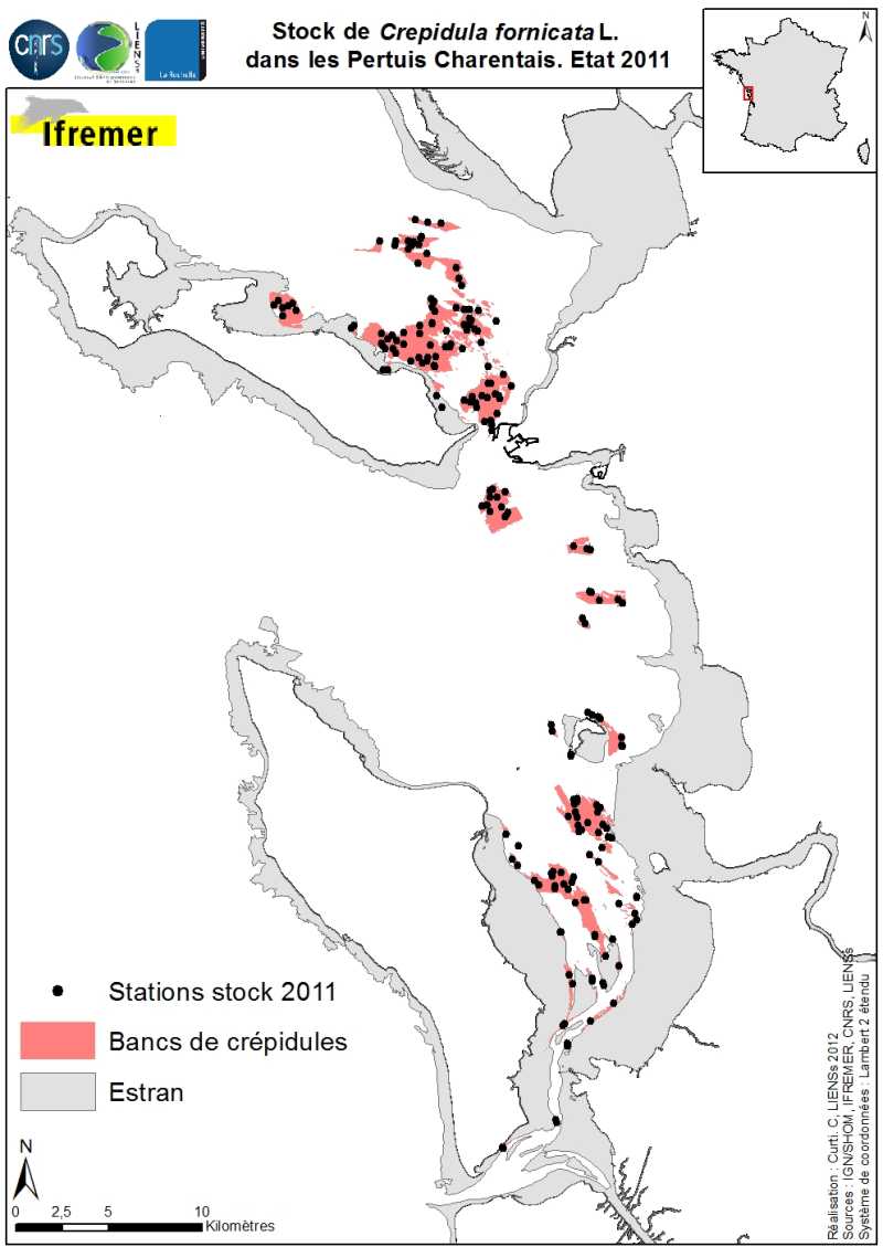
Stocks (abundance and biomass) of the slipper limpet Crepidula fornicata Linnaeus, 1758 in the Pertuis Charentais shallows were estimated in 2011 and mapped (Sauriau et al., 2011). The influence of the estimate includes the Pertuis Breton, the eastern part Pertuis Antioch Fouras peninsula and the Bay of Marennes-Oléron where the latter earlier estimates are available. Contours and surface areas of the crepidula were previously determined by acoustic imaging performed aboard the VO/Haliotis in 2008 and 2009, interpreted and validated by spot sampling in 2009 (Curti, 2009). Sampling stocks of 2011 is based on a stratified random sample of 40 banks with a proportional distribution of sampling of 200 stations between banks. The listing for each crepidula bank stocks (abundance in millions, biomass in tonnes) both living and dead, these shells may provide support to potential new colonization.
-
Bathymetry of the Congo fan (synthesis, 2013), with a spatial resolution of 100 meters (WGS84 / Mercator 5°30'S). This dataset is a compilation of bathymetric data from several cruises. Cruise descriptions : - VANGRIESHEIM Annick (2005) BIOZRECUP2 cruise, RV Beautemps-Beaupré, https://doi.org/10.17600/5090030 - COCHONAT Pierre, ROBIN Agnès (1992) GUINESS I cruise, RV L'Atalante, https://doi.org/10.17600/92004211 - OPTIC CONGO 2 - MARSSET Tania, DROZ Laurence (2010) REPREZAI_LEG1 cruise, RV Pourquoi pas ?, https://doi.org/10.17600/10030170 - OLU Karine (2011) WACS cruise, RV Pourquoi pas ?, https://doi.org/10.17600/11030010 - SAVOYE Bruno (1998) ZAIANGO1 cruise, RV L'Atalante, https://doi.org/10.17600/98010100 - COCHONAT Pierre (1998) ZAIANGO2 cruise, RV L'Atalante, https://doi.org/10.17600/98010110 - BOURILLET Jean-François (2000) ZAIANGOCAR cruise, RV Le Suroît, https://doi.org/10.17600/20050 - GELI Louis (2000) ZAIANGO-OBS-BIOL cruise, RV Le Suroît, https://doi.org/10.17600/20040
-
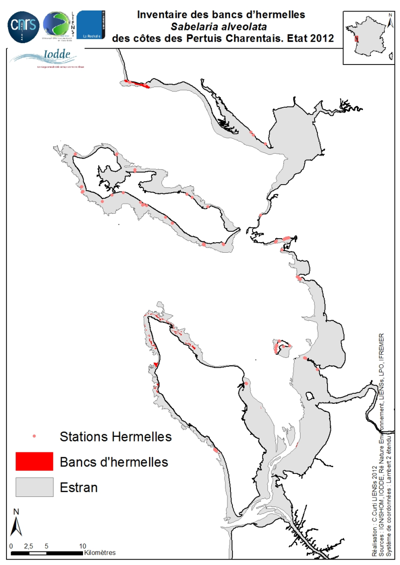
The geographical distribution of the main Sabellaria Hermelles alveolata beds (Linné, 1767) from the coast of the Pertuis Charentais was compiled from 2010 to 2012. The inventory focuses on the tidal beds (+ 6-0 m marine coast) and compiles two cartographic sources from the project CARTHAM Natura 2000 at sea of the Agency of Marine Protected Areas: 1) Hermelles inventories made on 2011 by the Association IODDE on the west of Oleron Island and 2) mapping inventory of intertidal marine habitats by LIENSs (in cooperation with CREOCEAN, Ré Nature Environnement, GEO-Transfert et la LPO Moëze-Oléron). Methodologies used by IODDE on Oléron combine ground truths with reports with Geographic Information System (GIS). The methodologies used by LIENSs to estimate the extension of the intertidal habitats throughout the Pertuis Charentais combine aerial image analysis, remote sensing, field validations by differential GPS and thematic analysis using GIS (Cajeri et al., 2012). It is during these ground truths that the presence of tackles or small Hermelles reefs was noted. The IODDE results have allowed an almost exhaustive inventory of Hermelles reefs west of Oleron. Those of LIENSs have clarified the distribution of Hermelles on most of the Pertuis Charentais foreshores.
-
-

Fichiers vectorisés des NRA, SR, ZNRA, ZSR et fichiers texte de la présence des opérateurs par NRA, informations sur les NRA, informations sur les ZSR, informations sur l'opticalisation des NRA, l'affaiblissement par pas de 5 db avant les petits multiplexeurs, affaiblissement par pas de 5 db après les petits multiplexeurs, affaiblissement par pas de 5db avant les multiplexeurs, affaiblissement par pas de 5db après les multiplexeurs
-

Lot de données concentrant les données relatives aux trames vertes et bleu sur le territoire du Languedoc-Roussillon
-
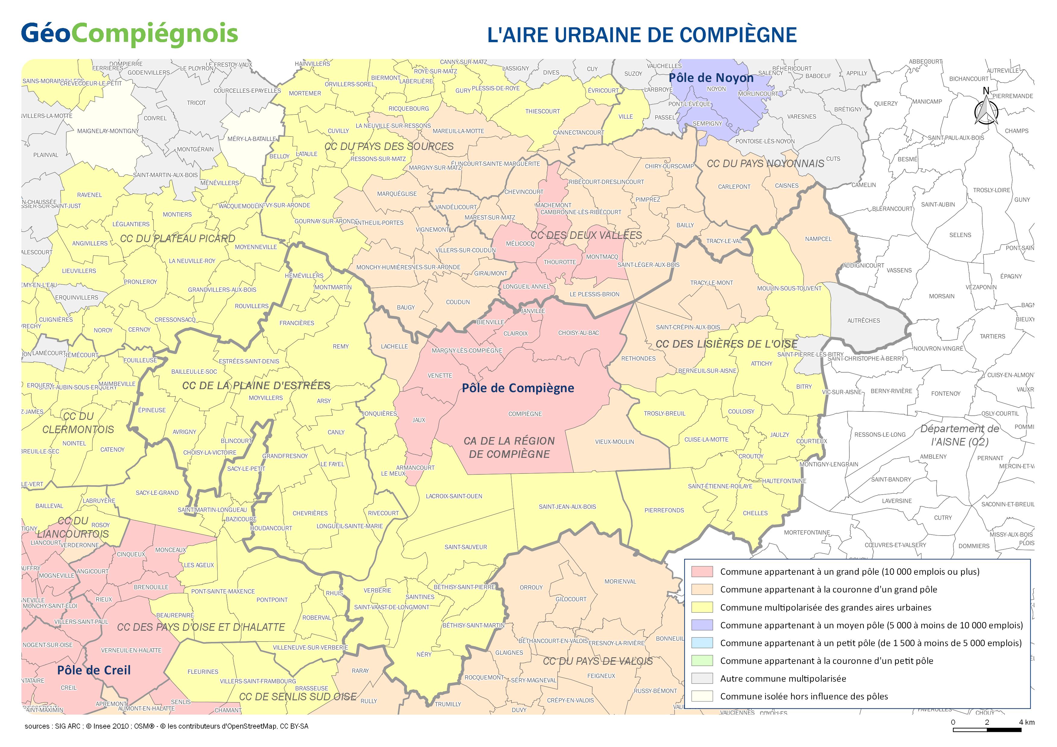
Carte délimitant l'aire urbaine de Compiègne. Donnée issue de l'Insee publiée en 2010.
-
Carte de l'occupation des sols en 9 thèmes
-
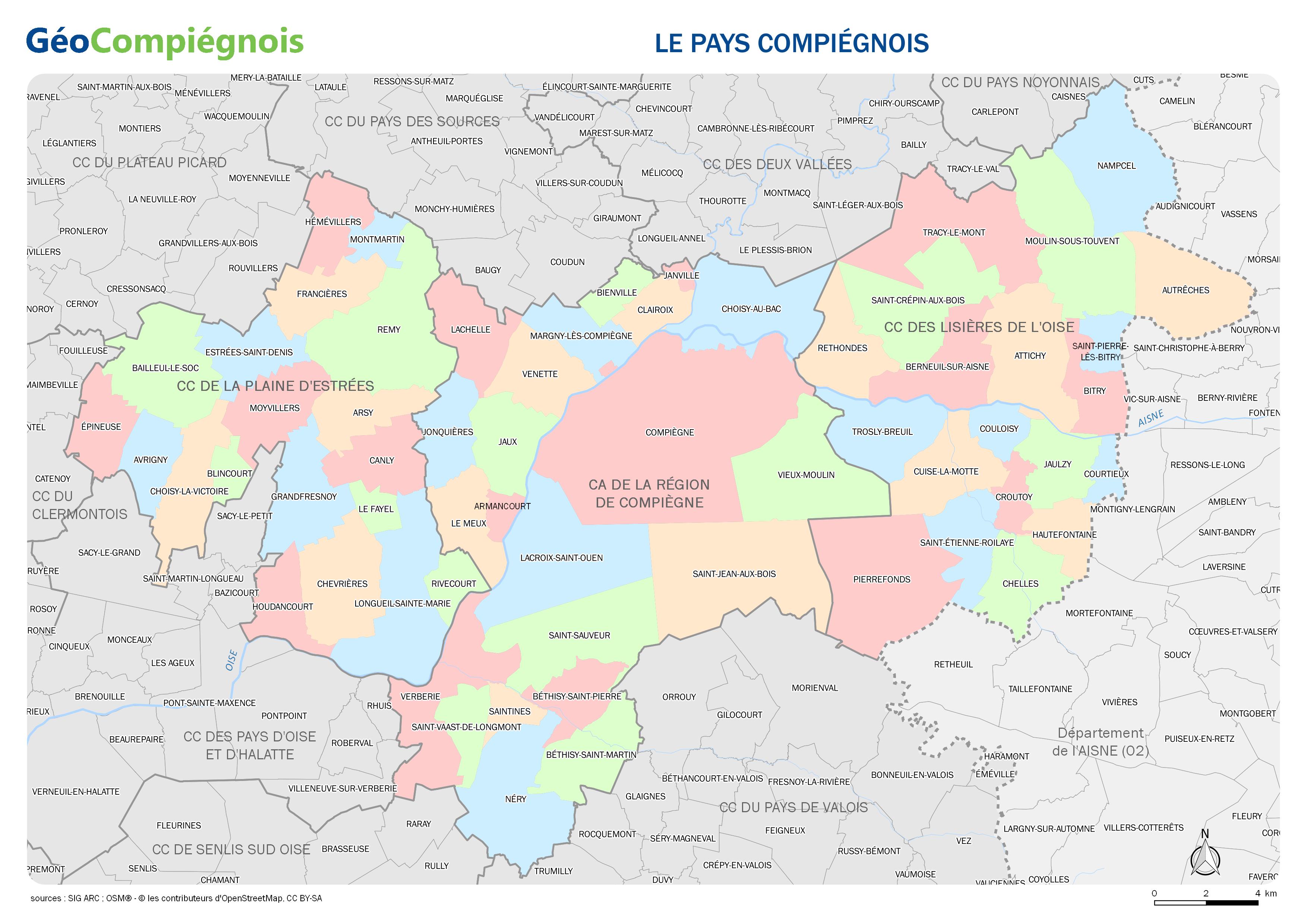
Carte administrative des communes et intercommunalités constituant le Pays Compiégnois.
-
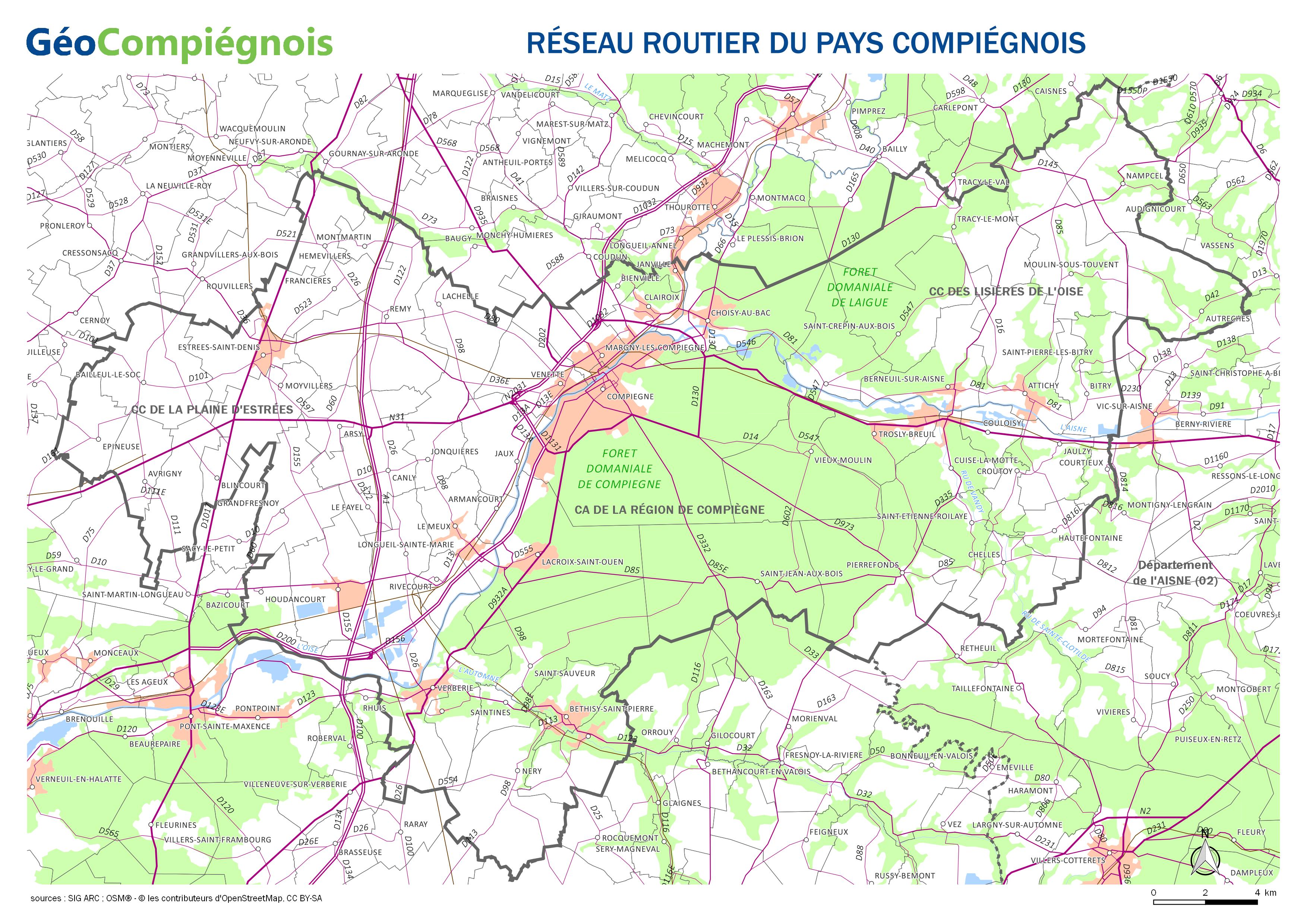
Carte sur les principaux axes routiers du Pays Compiégnois.