 Mon GéoSource
elevation
Type of resources
Available actions
Topics
INSPIRE themes
Keywords
Contact for the resource
Provided by
Years
Formats
Representation types
Update frequencies
status
Scale
Resolution
-
Geophysical and geochemical study of the Pacific-Antarctic ridge between S65/W175 and S60/W150. The first objective was to contribute to the understanding and modelling of the mechanisms of ocean ridge functioning on the scale of the basic accretion unit (< 100 km). The second was to study the zoning of the upper mantle on various scales, through investigating the geochemical signature of rocks from the axial valley. This cruise falls under the framework of the Inter-Ridge programme and is the result of cooperation between IFREMER/DRO/GM, INSU (CNRS,IPG, GRGS), Washington State University, Scripps (University of California) and the University of Chiba (Japan).
-
Raw singlebeam echosounder data from the French civil Research vessels, archived at SISMER (IFREMER)
-

Bathymetry of the French Guiana margin: the digital terrain model results from data compilation of 3 multibeam surveys conducted on the French research vessel RV L’Atalante. Grid resolution is 250 m. The DTM was processed as part of the French national program (EXTRAPLAC) for the delineation of the outer limit of the continental shelf beyond 200 nautical miles. - Guyaplac, 2003, R/V Atalante: Main source of the DTM was a cruise funded by the French National programme EXTRAPLAC. https://doi.org/10.17600/3010050 - Lobestory, 2004, R/V L'Atalante, https://doi.org/10.17600/4010030 - Cither1, 1993, R/V L'Atalante, https://doi.org/10.17600/93000010
-

Bathymetry around Saint-Paul and Amsterdam Islands: the Digital Terrain Model is the result of data compilation of multibeam surveys from 1984 to 2019. Grid resolution is 150 m. The DTM was processed as part of the French national program (EXTRAPLAC) for the delineation of the outer limit of the continental shelf beyond 200 nautical miles, and in collaboration between Ifremer and the Western Brittany University (UBO Brest). - MD157/ PLURIEL: 2006, R/V Marion Dufresne, SMF Seafalcon, https://doi.org/10.17600/6200130 - BOOMRANG-Leg6: 1996, R/V Melville, https://calisphere.org/item/ark:/20775/bb9424302r/ The datasets from the following cruises have been also integrated: - MD171/ GEISEIR1: 2009, R/V Marion Dufresne, SMF Seafalcon, https://doi.org/10.17600/9200050 - MD120/ ANTAUS: 2000, R/V Marion Dufresne, SMF Seafalcon, https://doi.org/10.17600/200090 - MD118/ DEFLO: 2000, R/V Marion Dufresne, SMF Seafalcon, https://doi.org/10.17600/200070 - MD106/ IPHIS: 1997, R/V Marion Dufresne, SMF Seafalcon, https://doi.org/10.17600/97200010 - HYDROAMSTERDAM: 1984, R/V Jean Charcot, https://doi.org/10.17600/84000111 - NBP0406: 2004, R/V Nathaniel B. Palmer, DOI 10.7284/905502 - MD197/ MYCTO: 2014, R/V Marion Dufresne, SMF Seafalcon, https://doi.org/10.17600/14002500 - MD211/ OBSAUSTRAL: 2018, R/V Marion Dufresne, EM122, https://doi.org/10.17600/18000490 - MD217/ OBSAUSTRAL: 2019, R/V Marion Dufresne, EM122, https://doi.org/10.17600/18000885 - TN362 (Coring to Reconstruct Ocean Circulation and Carbon-dioxide Across 2 Seas: CROCCA-2s), R/V Thomas G. Thompson, 2018. 10.7284/908704
-
-
Reconnaissance geophysique, geologique, petrographique et geochimique systematique.Transit valorisé Le Cap-Singapour
-
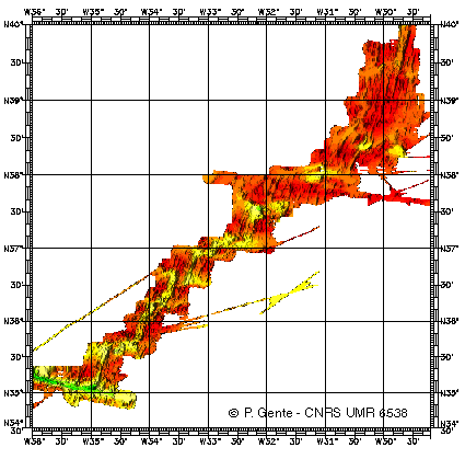
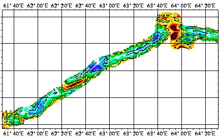
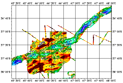
Bathymetry data of the ridge axis of Mohn's ridge (NE Atlantic) in order to study the mecanisms of the oceanic accretion.
-
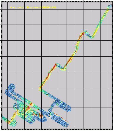
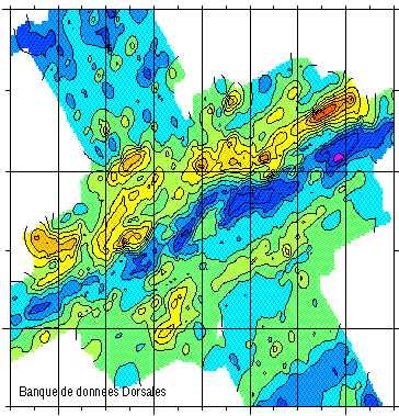
Reconnaissance geophysique, geologique, petrographique et geochimique systematique du point triple de Rodriguez ou convergent trois dorsales medio-oceanique. Exploration geophysique, geologique, petrographiqueet geochimique d'un segment de la zone axiale de chacune des trois dorsales. Reconnaissance, dans le bassin de Wharton, d'une dorsale fossile.
-
Reconnaissance geophysique, geologique, petrographique et geochimique systematique.Transit valorisé Le Cap-Singapour
-
Geophysical and geochemical study of the Pacific-Antarctic ridge between S65/W175 and S60/W150. The first objective was to contribute to the understanding and modelling of the mechanisms of ocean ridge functioning on the scale of the basic accretion unit (< 100 km). The second was to study the zoning of the upper mantle on various scales, through investigating the geochemical signature of rocks from the axial valley. This cruise falls under the framework of the Inter-Ridge programme and is the result of cooperation between IFREMER/DRO/GM, INSU (CNRS,IPG, GRGS), Washington State University, Scripps (University of California) and the University of Chiba (Japan).