 Mon GéoSource
Research
Type of resources
Available actions
Topics
INSPIRE themes
Keywords
Contact for the resource
Provided by
Years
Formats
Representation types
Update frequencies
status
Scale
Resolution
-
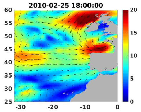
Wind analyses, estimated over the North Atlantic Ocean with a focus on some specific regions, are one the main ARCWIND (http://www.arcwind.eu/) project deliverables. They are estimated from various remotely sensed wind observations in combination with numerical model (WRF), with regular space (0.25deg in latitude and longitude), and time (00h:00, 06h:00, 12h:00, 18h:00 UTC), and based the method described in (Bentamy A., A. Mouche, A. Grouazel, A. Moujane, M. A. Ahmed. (2019): Using sentinel-1A SAR wind retrievals for enhancing scatterometer and radiometer regional wind analyses . International Journal Of Remote Sensing , 40(3), 1120-1147 . https://doi.org/10.1080/01431161.2018.1524174).
-
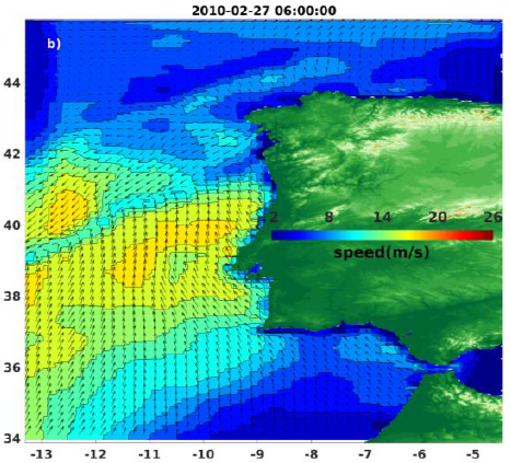
Wind analyses, estimated over the North Atlantic Ocean with a focus on some specific regions, are one the main ARCWIND (http://www.arcwind.eu/) project deliverables. They are estimated from various remotely sensed wind observations in combination with numerical model (WRF), with regular space (0.125deg in latitude and longitude), and time (00h:00, 06h:00, 12h:00, 18h:00 UTC), and based the method described in (Bentamy A., A. Mouche, A. Grouazel, A. Moujane, M. A. Ahmed. (2019): Using sentinel-1A SAR wind retrievals for enhancing scatterometer and radiometer regional wind analyses . International Journal Of Remote Sensing , 40(3), 1120-1147 . https://doi.org/10.1080/01431161.2018.1524174).
-
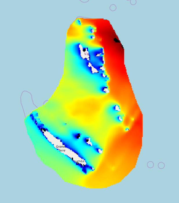
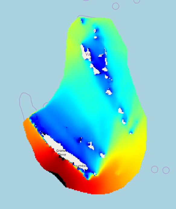
IOWAGA sea-states hindcast database generated by the wave model WAVEWATCH-III and forced by ECMWF winds on the New Caledonia grid over 2009-2017 period.
-
IOWAGA sea-states hindcast database generated by the wave model WAVEWATCH-III and forced by CFSR winds on the New Caledonia grid over 1990-2015 period.
-
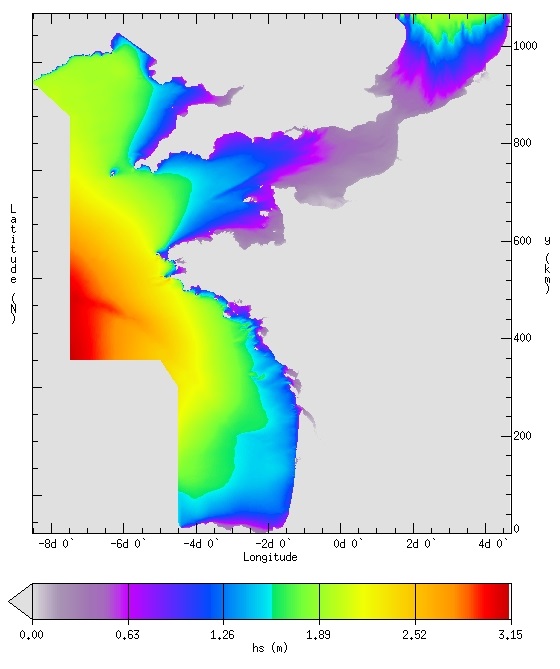
IOWAGA sea-states hindcast database generated by the wave model WAVEWATCH-III and forced by ECMWF winds on the French coast of the Atlantic ocean unstructured grid over 2008-2018 period.
-
Raw underway marine gravity data from the French civil Research vessels and archived at SISMER (IFREMER)
-
Raw seismic reflexion data collected on board of the French oceanographic fleet managed by IFREMER and archived at SISMER.
-

Bathymetry around Saint-Paul and Amsterdam Islands: the Digital Terrain Model is the result of data compilation of multibeam surveys from 1984 to 2019. Grid resolution is 150 m. The DTM was processed as part of the French national program (EXTRAPLAC) for the delineation of the outer limit of the continental shelf beyond 200 nautical miles, and in collaboration between Ifremer and the Western Brittany University (UBO Brest). - MD157/ PLURIEL: 2006, R/V Marion Dufresne, SMF Seafalcon, https://doi.org/10.17600/6200130 - BOOMRANG-Leg6: 1996, R/V Melville, https://calisphere.org/item/ark:/20775/bb9424302r/ The datasets from the following cruises have been also integrated: - MD171/ GEISEIR1: 2009, R/V Marion Dufresne, SMF Seafalcon, https://doi.org/10.17600/9200050 - MD120/ ANTAUS: 2000, R/V Marion Dufresne, SMF Seafalcon, https://doi.org/10.17600/200090 - MD118/ DEFLO: 2000, R/V Marion Dufresne, SMF Seafalcon, https://doi.org/10.17600/200070 - MD106/ IPHIS: 1997, R/V Marion Dufresne, SMF Seafalcon, https://doi.org/10.17600/97200010 - HYDROAMSTERDAM: 1984, R/V Jean Charcot, https://doi.org/10.17600/84000111 - NBP0406: 2004, R/V Nathaniel B. Palmer, DOI 10.7284/905502 - MD197/ MYCTO: 2014, R/V Marion Dufresne, SMF Seafalcon, https://doi.org/10.17600/14002500 - MD211/ OBSAUSTRAL: 2018, R/V Marion Dufresne, EM122, https://doi.org/10.17600/18000490 - MD217/ OBSAUSTRAL: 2019, R/V Marion Dufresne, EM122, https://doi.org/10.17600/18000885 - TN362 (Coring to Reconstruct Ocean Circulation and Carbon-dioxide Across 2 Seas: CROCCA-2s), R/V Thomas G. Thompson, 2018. 10.7284/908704
-
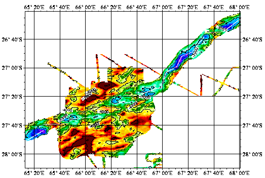
Reconnaissance geophysique, geologique, petrographique et geochimique systematique du point triple de Rodriguez ou convergent trois dorsales medio-oceanique. Exploration geophysique, geologique, petrographiqueet geochimique d'un segment de la zone axiale de chacune des trois dorsales. Reconnaissance, dans le bassin de Wharton, d'une dorsale fossile.
-
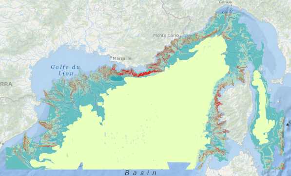
Geomorphological analysis of the continental slope of the Mediterranean sea based on a 100m Data Terrain Model (DTM). This DTM is a synthesis of data acquired during sea surveys.