 Mon GéoSource
/Metropolitan France/Channel-North Sea
Type of resources
Available actions
INSPIRE themes
Provided by
Years
Representation types
Update frequencies
status
Scale
Resolution
-
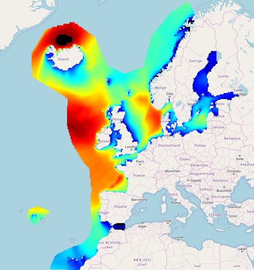
IOWAGA sea-states hindcast database generated by the wave model WAVEWATCH-III and forced by ECMWF winds on the French coast of the Atlantic ocean unstructured grid over 2008-2018 period.
-
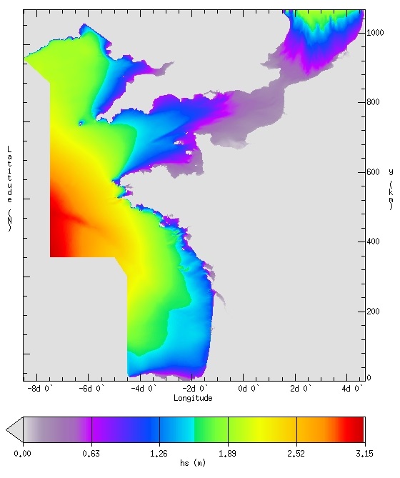
IOWAGA sea-states hindcast database generated by the wave model WAVEWATCH-III and forced by ECMWF winds on the North East Atlantic grid over 1990-2012 period.
-
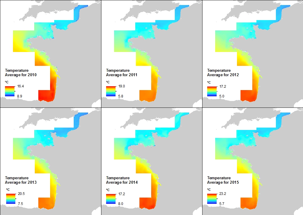
Cette climatologie à la résolution spatiale de 500 mètres a été établie à partir des archives de série temporelles issues du rejeu hydrodynamique réalisée avec le modèle MARS 3D et la librairie AGRIF le long de la façade atlantique française. La variable mise à disposition est la température.Les valeurs sont exprimées en degrés Celsius. La valeur de chaque pixel est une moyenne des valeurs des 40 niveaux verticaux pris en compte par le modèle.
-

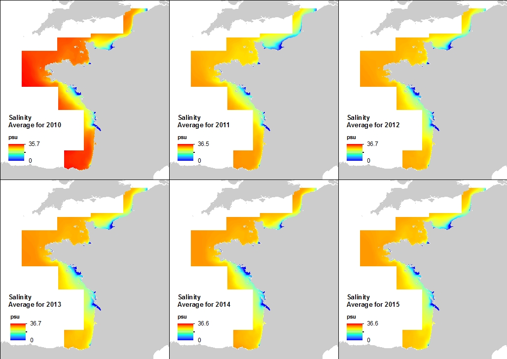
Cette climatologie à la résolution spatiale de 500 mètres a été établie à partir des archives de série temporelles issues du rejeu hydrodynamique réalisée avec le modèle MARS 3D et la librairie AGRIF le long de la façade atlantique française. La variable mise à disposition est la Salinité. Les valeurs sont exprimées en psu. Le niveau vertical considéré est la surface de l'océan.
-
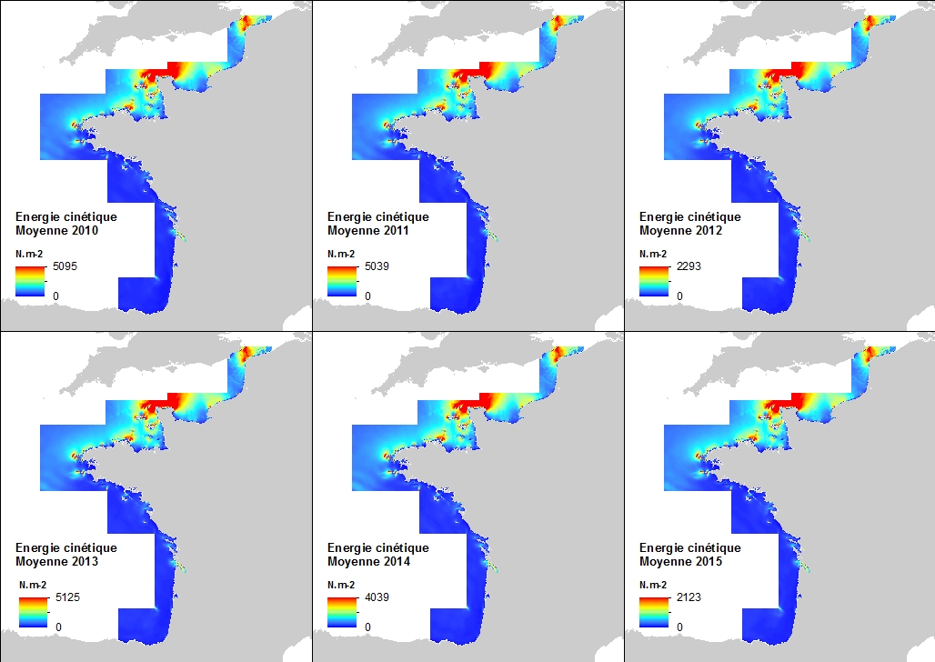
Cette climatologie à la résolution spatiale de 500 mètres a été établie à partir des archives de série temporelles issues du rejeu hydrodynamique réalisée avec le modèle MARS 3D et la librairie AGRIF le long de la façade atlantique française. La variable mise à disposition est l'énergie cinétique induite par les courants marins résultant de la marée, des différences de densité, et de l'action des vents. La formule mathématique utilisée pour l'énergie cinétique est 0.5mv², m étant la masse volumique de l'eau de mer (1027 kg.m-3) et v la vitesse des courants.Les valeurs sont exprimées en N.m-2 (Newton par mètre carré). Le niveau vertical considéré est le fond de l'océan.
-
Cette climatologie à la résolution spatiale de 500 mètres a été établie à partir des archives de série temporelles issues du rejeu hydrodynamique réalisée avec le modèle MARS 3D et la librairie AGRIF le long de la façade atlantique française. La variable mise à disposition est la salinité. Les valeurs sont exprimées en psu. Le niveau vertical considéré est le fond de l'océan.
-
Données d’occurrence des échouages de mammifères marins collectées par les correspondants du Réseau National Echouages (date, position, espèce) en métropole en 2014-2020. cd_nom: code de l'espèce observée selon taxref lb_nom: nom latin de l'espèce observée selon taxref nom_commun: nom commun de l'espèce observée selon taxref date_obs: jj/mm/aaaa, date de l'observation de l'animal échoué com_codes_insee: code de la commune de l'échouage selon l'INSEE com_nom: nom de la commune selon l'INSEE com_coord_lat: y en degrés décimaux de la commune de l'échouage com_coord_long: x en degrés décimaux de la commune de l'échouage id_mammifere: référence de l'animal dans la base de données Pelagis identiteObservateur: nom du correspondant ayant effectué l'observation organismeObservateur: organisme du correspondant ayant effectué l'observation organismeGestionnaireDonnees: organisme assurant la gestion de la base de données
-
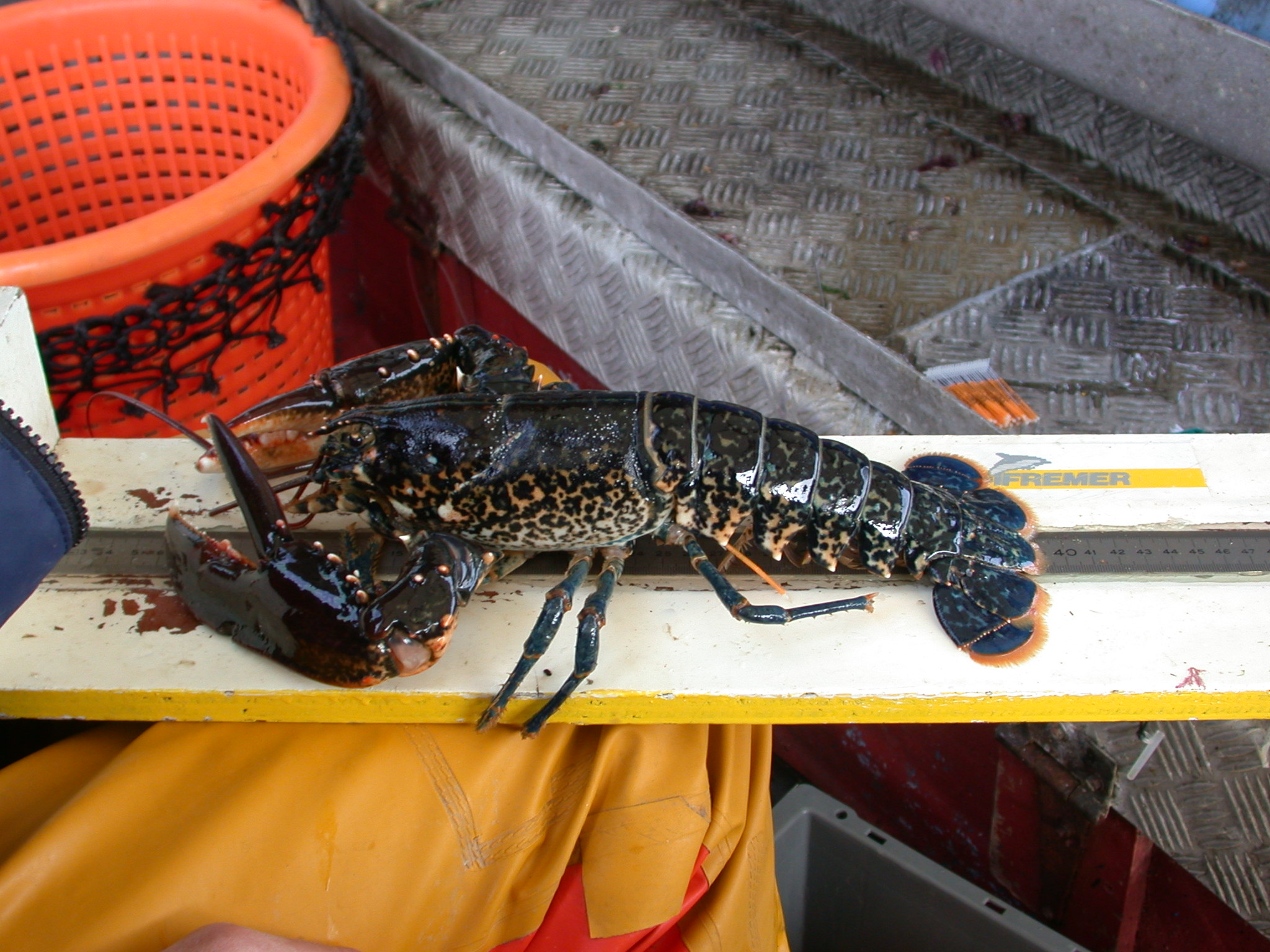
Dans le cadre de l’implantation d’une centrale électronucléaire sur le littoral de la commune de Flamanville, Electricité de France a confié à l’Ifremer les études écologiques et halieutiques aux abords du site. L’une des expertises consiste à réaliser chaque année deux campagnes de pêche des crustacés. Leurs objectifs est le suivi des fluctuations naturelles des principaux indicateurs retenus lors de la mise en route de la centrale et d’évaluer l’impact de celle-ci sur la pêcherie environnante.
-

Le projet NourDem vise à réaliser des campagnes annuelles de chalutage dans les trois estuaires de la Seine, de la Loire et de la Gironde.
-
Les données VMS (Vessel Monitoring System) correspondent aux données du système communautaire de surveillance par satellite des navires de pêche qui fournit à intervalles réguliers des données sur la position, la route et la vitesse des navires aux autorités de pêche.