 Mon GéoSource
1000000
Type of resources
Available actions
Topics
INSPIRE themes
Keywords
Contact for the resource
Provided by
Years
Formats
Representation types
Update frequencies
status
Scale
Resolution
-

Composition de la densité totale moyenne de chaque campagne d'échantillonnage observée par vidéo rotative STAVIRO par famille taxonomique (nombre d’individus dans un rayon de 5 m autour du système STAVIRO, rapporté à une surface de 100 m² et moyenné par campagne).
-
La donnée associée met en évidence l'effort d'observation réalisé lors de la campagne d'acquisition de données d'Observation sur plateforme aérienne SAMM2 (Suivi aérien de la Mégafaune Marine) réalisée par l'Observatoire PELAGIS. L'effort d'observation est matérialisé sous la forme d'un linéaire calqué sur les transects prévus. Description de la table attributaire : region char 30 Zone d'étude platform char 10 Plateforme d'observation : ovipa/ovibat survey char 15 Nom de la campagne computer char 5 Identifiant du système sur lequel le vol est effectué sector char 10 Secteur d'échantillonnage strate char 5 Strate d'échantillonnage transectN char 10 Transect d'échantillonnage crossNb int Nombre de passage sur le transectN effortGrp char 20 Numéro du groupe d'effort leg char 70 Numéro d'effort txt leg_id int Numéro d'effort (pour un LEG uniquement) left char 5 Arrière gauche (position gauche sur une plate-forme simple) right char 5 Arrière droit (position droite sur une plate-forme simple) navigator char 5 Navigateur (position centrale) beginTime char 20 Temps auquel a été commencé le parcours endTime char 20 Temps auquel s'est terminé le parcours status char 5 Status du parcours seaState char 5 Code pour l'état de la mer selon l'échelle de Beaufort cloudCover char 5 Couverture nuaugeuse défini par le système des octats (0 pour dégagé < 8 pour complètement couvert) glareFrom char 5 Début de la zone d'éblouissement en degré (le nez de l'avion 0°) glareTo char 5 Fin de la zone d'éblouissement en degré (le nez de l'avion 0°) glareSeverity char 5 ntensité d'éblouissement (0 aucun éblouissement < 3 éblouissement fort) turbidity char 5 Turbidité/transparence de l'eau (0 eau claire < 2 eau turbide, 9 turbidité inconnue) subjective char 20 Détectabilité. Estimation des observateurs en fonction des autres paramètres si les conditions sont bonnes ou non. Il s'agit de deux lettres, une pour le côté gauche et une pour le côté droit. (E excellentes, G bonnes, M moyennes et P pauvres). comment char 400 Commentaires sur le parcours lat double Latitude géographique en degré décimal du début du parcours lon double Longitude géographique en degré décimal du début du parcours latEnd double Latitude géographique en degré décimal de la fin du parcours lonEnd double Longitude géographique en degré décimal de la fin du parcours lengthKm double Longueur de l'effort en km engin char 30 Immatriculation de l'avion utilisé pour le vol speed int Vitesse (km/h) lors de la capture altitude char 15 Altitude (feet) lors de la capture coordN char 15 Code EPSG du système de coordonnées dans lequel les valeurs de distance ont été calculées
-
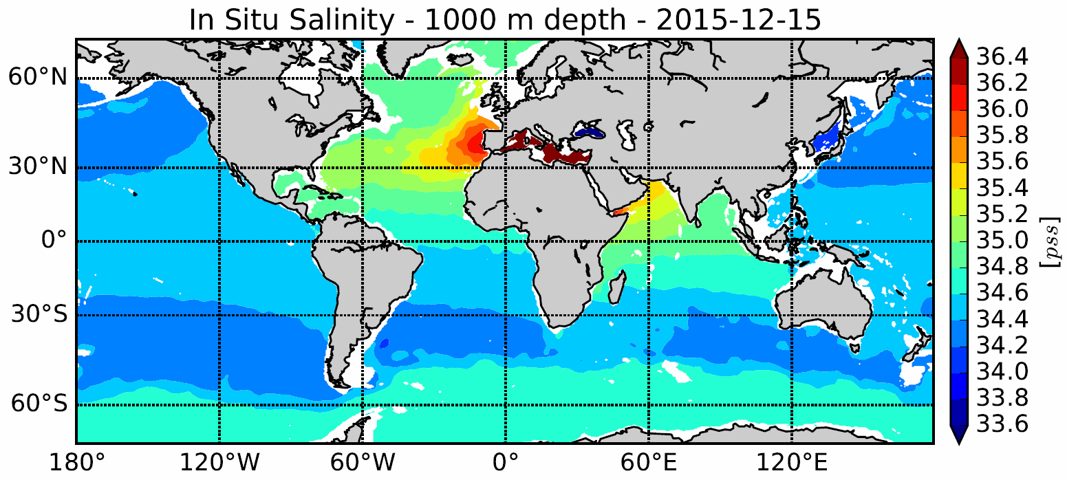
Le Système d'analyse in situ (ISAS) a été développé pour produire des champs de température et de salinité qui préservent autant que possible les capacités d'échantillonnage du temps et de l'espace du réseau des flotteurs ARGO. Depuis la première analyse globale réalisée en 2009, le système a été étendu pour tenir compte de tous les types de profils verticaux ainsi que les séries temporelles. Les champs grillé ISAS sont entièrement basés sur des mesures in situ. Le système vise à surveiller l'évolution des propriétés de l'océan en fonction du temps pour les études climatologiques et permettre un calcul facile des indices climatiques. Un traitement en temps différé de l'ensemble de données 2002-2012 a été réalisé à l'aide de la version 6 d'ISAS et la mise à jour des statistiques pour produire l'analyse ISAS-13. Notez que ISAS-V6 est mis en œuvre comme outil d'analyse opérationnelle au centre de données Coriolis depuis juin 2014.
-
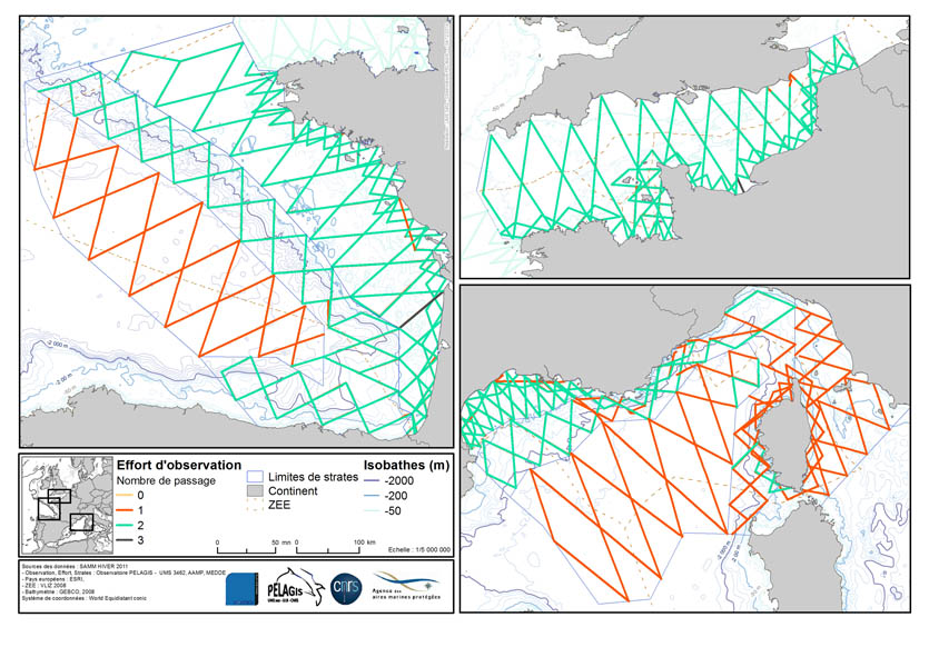
La donnée associée met en évidence l'effort d'observation réalisé lors de la campagne d'acquisition de données d'Observation sur plateforme aérienne SAMM1 (Suivi aérien de la Mégafaune Marine) réalisée par l'Observatoire PELAGIS. L'effort d'observation est matérialisé sous la forme d'un linéaire calqué sur les transects prévus. Description de la table attributaire : region char 30 Zone d'étude platform char 10 Plateforme d'observation : ovipa/ovibat survey char 15 Nom de la campagne computer char 5 Identifiant du système sur lequel le vol est effectué sector char 10 Secteur d'échantillonnage strate char 5 Strate d'échantillonnage transectN char 10 Transect d'échantillonnage crossNb int Nombre de passage sur le transectN effortGrp char 20 Numéro du groupe d'effort leg char 70 Numéro d'effort txt leg_id int Numéro d'effort (pour un LEG uniquement) left char 5 Arrière gauche (position gauche sur une plate-forme simple) right char 5 Arrière droit (position droite sur une plate-forme simple) navigator char 5 Navigateur (position centrale) beginTime char 20 Temps auquel a été commencé le parcours endTime char 20 Temps auquel s'est terminé le parcours status char 5 Status du parcours seaState char 5 Code pour l'état de la mer selon l'échelle de Beaufort cloudCover char 5 Couverture nuaugeuse défini par le système des octats (0 pour dégagé < 8 pour complètement couvert) glareFrom char 5 Début de la zone d'éblouissement en degré (le nez de l'avion 0°) glareTo char 5 Fin de la zone d'éblouissement en degré (le nez de l'avion 0°) glareSeverity char 5 ntensité d'éblouissement (0 aucun éblouissement < 3 éblouissement fort) turbidity char 5 Turbidité/transparence de l'eau (0 eau claire < 2 eau turbide, 9 turbidité inconnue) subjective char 20 Détectabilité. Estimation des observateurs en fonction des autres paramètres si les conditions sont bonnes ou non. Il s'agit de deux lettres, une pour le côté gauche et une pour le côté droit. (E excellentes, G bonnes, M moyennes et P pauvres). comment char 400 Commentaires sur le parcours lat double Latitude géographique en degré décimal du début du parcours lon double Longitude géographique en degré décimal du début du parcours latEnd double Latitude géographique en degré décimal de la fin du parcours lonEnd double Longitude géographique en degré décimal de la fin du parcours lengthKm double Longueur de l'effort en km engin char 30 Immatriculation de l'avion utilisé pour le vol speed int Vitesse (km/h) lors de la capture altitude char 15 Altitude (feet) lors de la capture coordN char 15 Code EPSG du système de coordonnées dans lequel les valeurs de distance ont été calculées
-
Utilisez ce modèle pour décrire une carte au format PDF, Image ou une carte dynamique (eg. WMC).
-
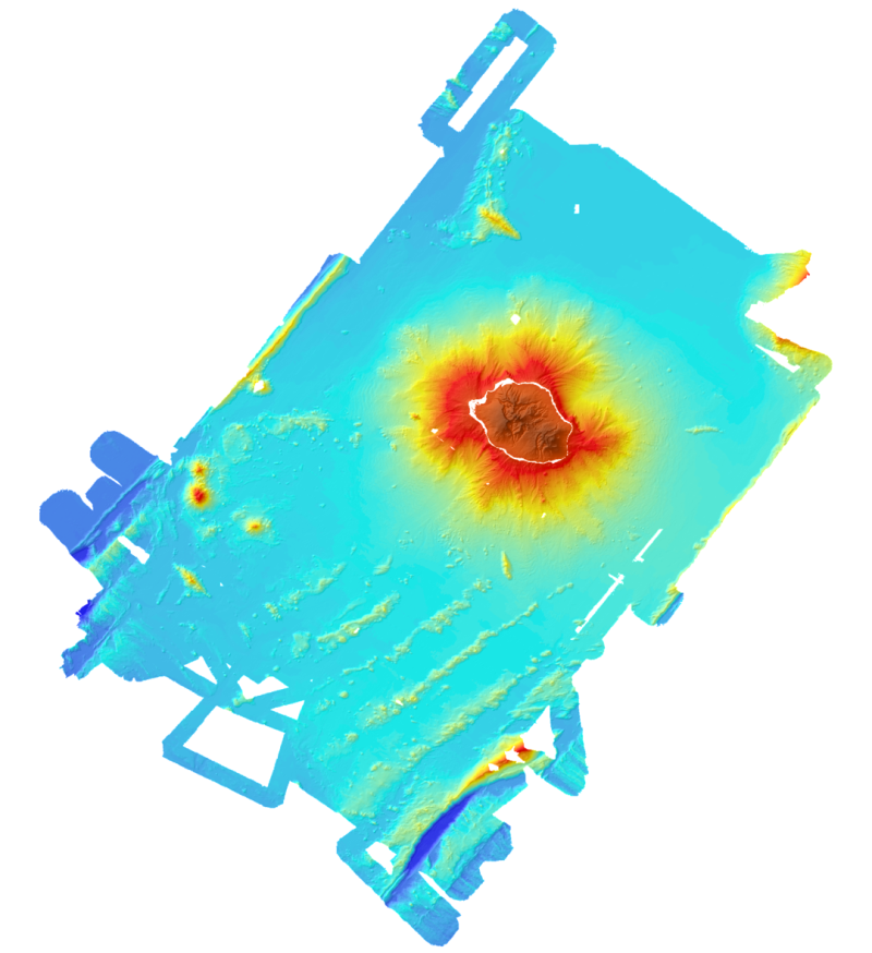
Modèle bathymétrique et topographique de l'île de La Réunion. La topographie provient de données de l'IGN. La bathymétrie est issue des données de sondeurs multifaisceaux acquises durant les campagnes Forever (2006, sondeur EM12D), Eroder1 (2006, sondeur EM120) et Eroder2 (2007, sondeur EM120). Le pas de la grille est de 300m.
-
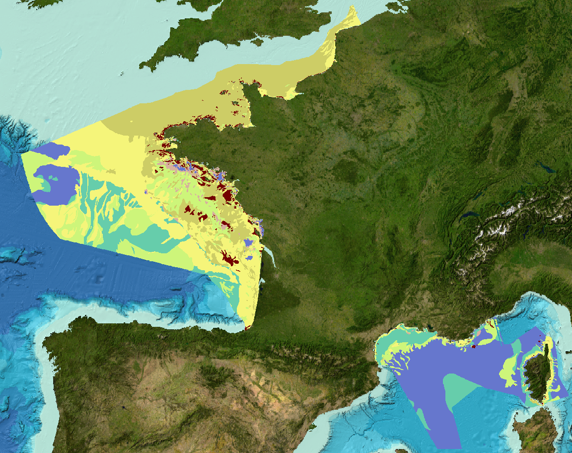
Carte des formations superficielles à 1 : 1 000 000 produite par la France dans le cadre du work-package 3 du projet européen EMODNet Geology phase 2 à l'intérieur de la ZEE métropolitaine française. Et indexation et carte de fiabilité des données-source.
-
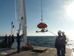
Station benthique permettant à minima de mesurer la turbidité, la température et la pression
-
Ces modèles bathymétriques sont le résultat de la compilation de données et modèles numériques antérieurs à 2008 dans la zone du Golfe de Gascogne. Ces jeux de données sont disponibles à 500 m et 1 000 m de résolution. Les isobathes sont aussi disponibles pour les deux modèle numérique de terrain (MNT) équidistantes de 50 m pour le MNT 500 m, et équidistantes de 100 m pour le MNT 1 000 m. Accès tout public sous conditions.
-
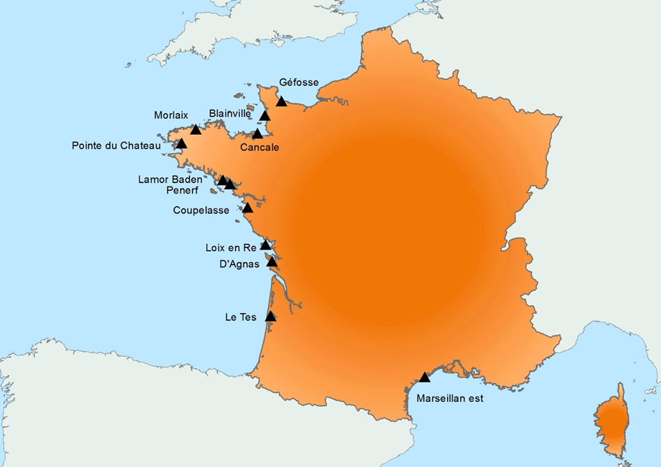
Création en 2015, faisant suite au RESCO mis en place en 2009, et au REMORa mis en place en 1993. En 2015, la structure et le fonctionnement de l’ancien réseau RESCO a été utilisée afin d’appliquer une surveillance planifiée sur les huîtres creuses. Plus précisément, les lots sentinelles utilisés par le réseau, représentant 3 classes d’âge (6 mois, 18 mois conservés de l’année précédente et 30 mois conservés de l’année précédente) sont suivis régulièrement (fréquence bi-mensuelle à mensuelle) tout au long de l’année sur 12 sites ateliers nationaux (correspondant aux sites anciennement RESCO). Lors de chaque passage, des dénombrements sont effectués afin d’évaluer le taux de mortalité, et différents types d’analyses diagnostiques de laboratoire seront réalisés : - au temps initial, les nouveaux lots de naissain (Naissains Standardisés Ifremer) subiront des analyses spécifiques par PCR afin de rechercher les agents infectieux potentiellement présents (OsHV-1 et Vibrio aestuarianus) mais aussi des analyses non spécifiques (histologie, bactériologie classique ) pour la détection éventuelle d’autres agents pathogènes - pour la détection de maladies émergentes, les premiers lots moribonds détectés pour chaque classe d’âge, pour chaque site, subiront des analyses diagnostiques de laboratoire spécifiques (PCR OsHV-1 et Vibrio aestuarianus) et non spécifiques (histologie) afin de déceler le plus précocement possible d’éventuelles maladies émergentes sur ces lots sentinelles - pour la détection de maladie exotique, en l’absence de hiérarchisation des maladies exotiques des huîtres creuses disponible, le parasite Mikrocytos mackini a été choisi pour être surveillé car l’infection par ce parasite est réglementée au niveau européen, sur l'un des sites du RESCOII (Loix en Ré) identifié préalablement comme un site à risque vis à vis de l'introduction de ce parasite. Parallèlement à ces suivis de mortalités et ces analyses diagnostiques de laboratoire, chaque site est équipé de sonde permettant l’acquisition de paramètres environnementaux (température, pression, salinité) à haute fréquence. Les différents résultats sont bancarisés dans la base Quadrige², et sont disponibles pour les différents acteurs concernés. Le réseau est adossé à un site internet dédié permettant la diffusion des objectifs, des protocoles et des résultats, et sera mis à jour tous les mois. Parallèlement, des bulletins d’information synthétisant les résultats obtenus sont diffusés par mail tous les mois aux services de l’Etat.