 Mon GéoSource
/Physical Environment/Climatology
Type of resources
Available actions
INSPIRE themes
Provided by
Years
Representation types
Resolution
-
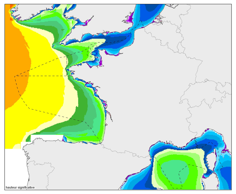
Moyennes, percentile 90 et percentile 99 des hauteurs significatives et des agitations significatives. De la Mer du Nord à la mer Méditerranée, à une résolution de 2 minutes.
-
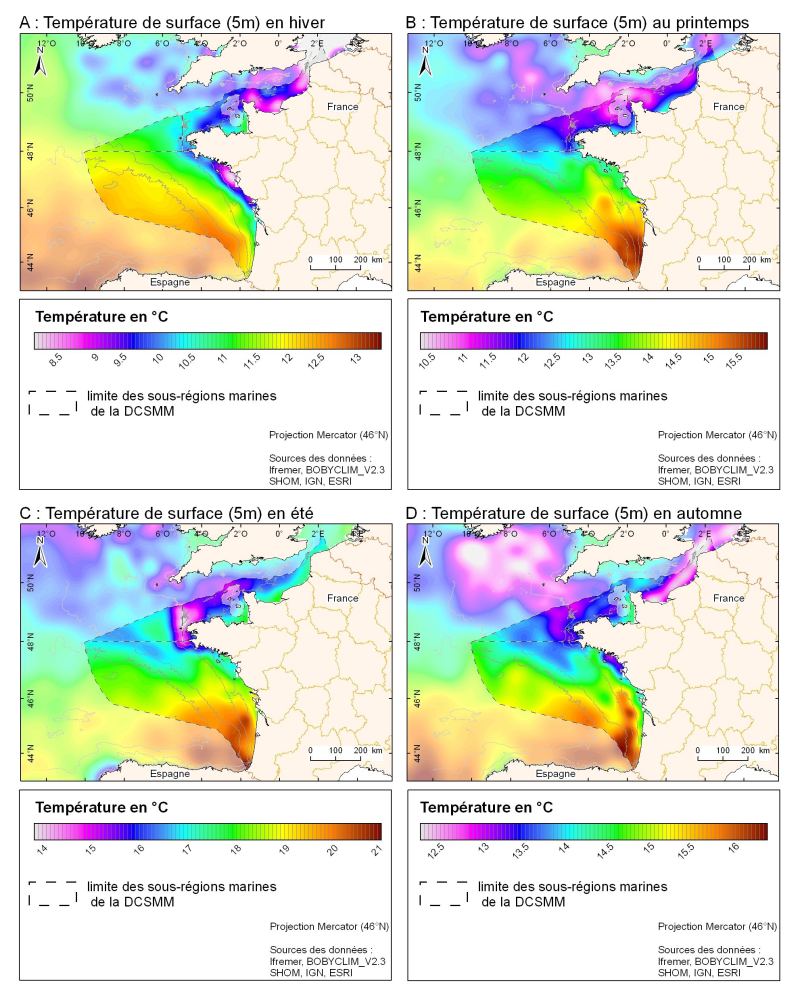
Champ de température de surface (en °C) saisonnié 3D obtenu par analyse objective (interpolation) de la donnée brute in situ, à 5 m de profondeur. Dans le cadre du Défi Golfe de Gascogne et du programme d'Océanographie Côtière Operationnelle Prévimer, les services SISMER et DYNECO-PHYSED de l'IFREMER ont constitué une base de données hydrologiques unique du Golfe de Gascogne, à partir de mesures CTD, Bouteilles, XBT/ MBT et Profileurs provenant de plusieurs centres de données mondiaux, afin de réaliser un atlas climatologique de la région en température et salinité.
-
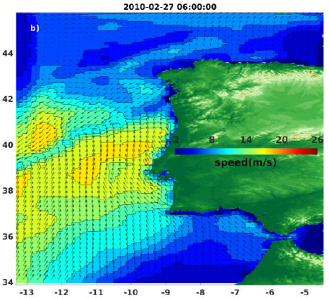
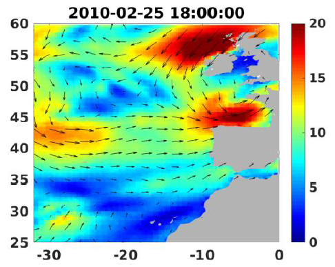
Wind analyses, estimated over the North Atlantic Ocean with a focus on some specific regions, are one the main ARCWIND (http://www.arcwind.eu/) project deliverables. They are estimated from various remotely sensed wind observations in combination with numerical model (WRF), with regular space (0.125deg in latitude and longitude), and time (00h:00, 06h:00, 12h:00, 18h:00 UTC), and based the method described in (Bentamy A., A. Mouche, A. Grouazel, A. Moujane, M. A. Ahmed. (2019): Using sentinel-1A SAR wind retrievals for enhancing scatterometer and radiometer regional wind analyses . International Journal Of Remote Sensing , 40(3), 1120-1147 . https://doi.org/10.1080/01431161.2018.1524174).
-
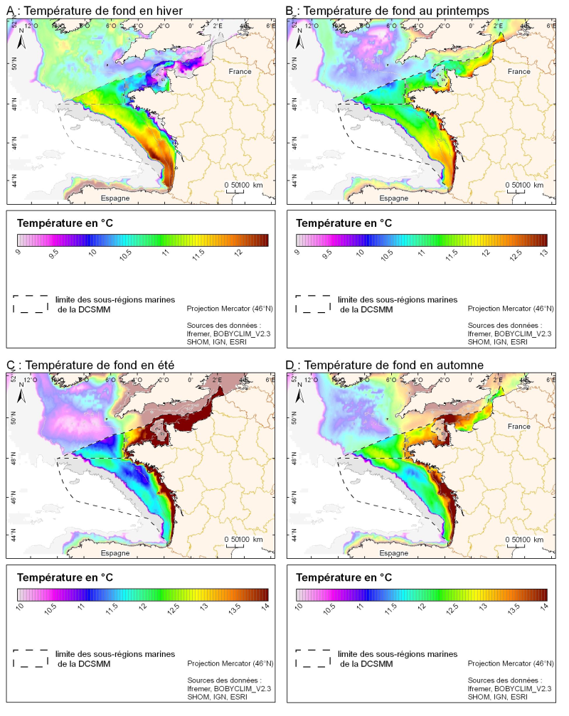
Champ de température (en °C) saisonnié 3D obtenu par analyse objective (interpolation) de la donnée brute in situ, à proximité du fond. Dans le cadre du Défi Golfe de Gascogne et du programme d'Océanographie Côtière Operationnelle Prévimer, les services SISMER et DYNECO-PHYSED de l'IFREMER ont constitué une base de données hydrologiques unique du Golfe de Gascogne, à partir de mesures CTD, Bouteilles, XBT/ MBT et Profileurs provenant de plusieurs centres de données mondiaux, afin de réaliser un atlas climatologique de la région en température et salinité.
-
Wind analyses, estimated over the North Atlantic Ocean with a focus on some specific regions, are one the main ARCWIND (http://www.arcwind.eu/) project deliverables. They are estimated from various remotely sensed wind observations in combination with numerical model (WRF), with regular space (0.25deg in latitude and longitude), and time (00h:00, 06h:00, 12h:00, 18h:00 UTC), and based the method described in (Bentamy A., A. Mouche, A. Grouazel, A. Moujane, M. A. Ahmed. (2019): Using sentinel-1A SAR wind retrievals for enhancing scatterometer and radiometer regional wind analyses . International Journal Of Remote Sensing , 40(3), 1120-1147 . https://doi.org/10.1080/01431161.2018.1524174).
-
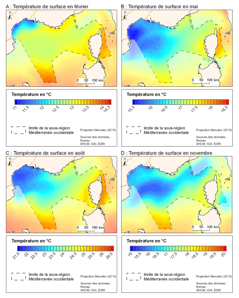
La résolution spatiale de la climatologie satellitale permet une description plus fine des variations spatio-temporelles de la température de surface dans cette partie nord du bassin occidental. Il existe pour la température de surface des climatologies basées sur la mesure infrarouge par satellites qui proposent une résolution spatiale de l'ordre du kilomètre.
-
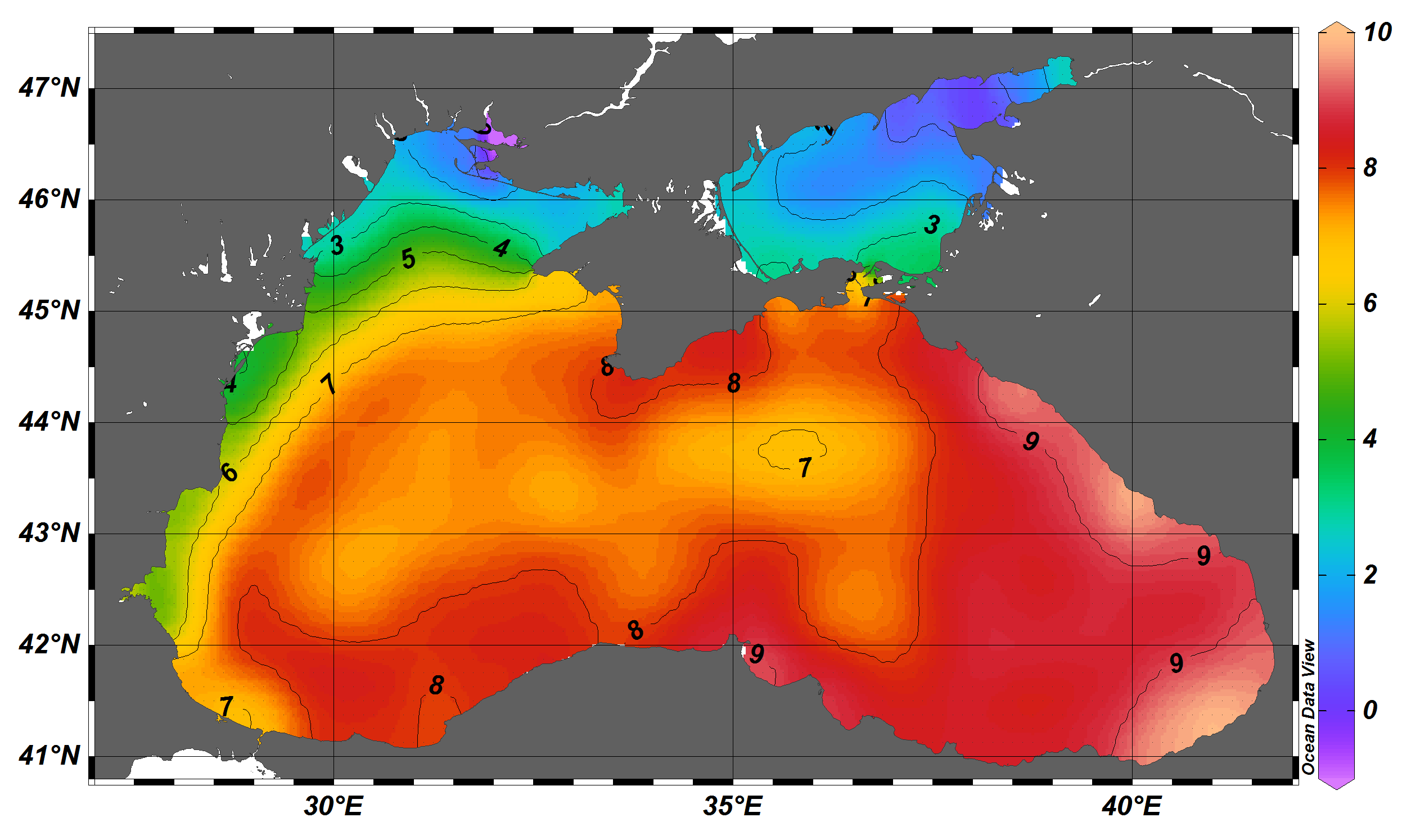
The SDC_BLS_CLIM_TS_V1 product contains Temperature and Salinity Climatologies for Black Sea including the seasonal and monthly fields for period 1955-2017 and seasonal fields for 6 decades starting from 1955 to 2014. The climatic fields were computed from the integrated Black Sea dataset that combines data extracted from the 3 major sources: 1) SeaDataNet infrastructure, 2) World Ocean Database 2018, and 3) Coriolis Ocean Dataset for Reanalysis. The computation was done with the DIVAnd (Data-Interpolating Variational Analysis in n dimensions), version 2.3.1.