 Mon GéoSource
Bathymetry
Type of resources
Available actions
Topics
INSPIRE themes
Keywords
Contact for the resource
Provided by
Years
Representation types
Update frequencies
status
Service types
Scale
-
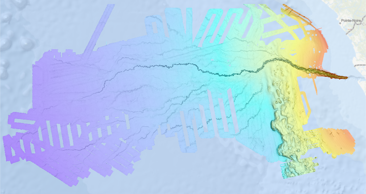
Bathymetry of the Congo fan (synthesis, 2013), with a spatial resolution of 100 meters (WGS84 / Mercator 5°30'S). This dataset is a compilation of bathymetric data from several cruises. Cruise descriptions : - VANGRIESHEIM Annick (2005) BIOZRECUP2 cruise, RV Beautemps-Beaupré, https://doi.org/10.17600/5090030 - COCHONAT Pierre, ROBIN Agnès (1992) GUINESS I cruise, RV L'Atalante, https://doi.org/10.17600/92004211 - OPTIC CONGO 2 - MARSSET Tania, DROZ Laurence (2010) REPREZAI_LEG1 cruise, RV Pourquoi pas ?, https://doi.org/10.17600/10030170 - OLU Karine (2011) WACS cruise, RV Pourquoi pas ?, https://doi.org/10.17600/11030010 - SAVOYE Bruno (1998) ZAIANGO1 cruise, RV L'Atalante, https://doi.org/10.17600/98010100 - COCHONAT Pierre (1998) ZAIANGO2 cruise, RV L'Atalante, https://doi.org/10.17600/98010110 - BOURILLET Jean-François (2000) ZAIANGOCAR cruise, RV Le Suroît, https://doi.org/10.17600/20050 - GELI Louis (2000) ZAIANGO-OBS-BIOL cruise, RV Le Suroît, https://doi.org/10.17600/20040
-
-
Bathymetry of the Crozet Islands, spatial resolution 100 meters. This Digital Terrain Model is a compilation of bathymetric data from several sources. Vertical reference : observed sea level Data process : Loubrieu Benoit, Pierre Delphine, Biville Romain, Le Duff Mathilde (2013). Digital Terrain Model for the HA04 hydroacoustic station, Crozet Islands, France. CB/GM/CTDI-BL2013-01 The data come from the cruises : - SCHLICH Roland (1998) KERIMIS-MD109 cruise, RV Marion Dufresne, https://doi.org/10.17600/98200010 - HUMLER Eric (2001) MD 121 / SWIFT cruise, RV Marion Dufresne, https://doi.org/10.17600/1200030 - METZL Nicolas, PIERRE Catherine (2001) VT 51 / OISO 6 cruise, RV Marion Dufresne, https://doi.org/10.17600/1200010 - ASLANIAN Daniel, HUMLER Eric, MICHEL Elisabeth (2002) MD 125 / SWIFT BIS-CARHOT cruise, RV Marion Dufresne, https://doi.org/10.17600/2200020 - MICHEL Elisabeth (2004) MD 136 / VIGO cruise, RV Marion Dufresne, https://doi.org/10.17600/4200110 - ROEST Walter (2005) MD 150 /DELCANO RISE-KERGUEPLAC2 cruise, RV Marion Dufresne, https://doi.org/10.17600/5200060 - VIALLY Roland, BRUNET Christian, ROYER Jean-Yves (2008) MD 165 / KERGUEPLAC 3 cruise, RV Marion Dufresne, https://doi.org/10.17600/8200010 - ROEST Walter, JOHNSON Sean (2010) MD176 Discovery Ridge-CrozetPlac cruise, RV Marion Dufresne, https://doi.org/10.17600/18001444 - CROSTA Xavier (2019) MD 218 / CROTALE cruise, RV Marion Dufresne, https://doi.org/10.17600/18000886 + transits of the R/V Marion Dufresne MD202 (2016) et MD207 (2017)
-
WFS for EMODNet HRSM CDI services by SeaDataNet
-

Bathymetry around Saint-Paul and Amsterdam Islands: the Digital Terrain Model is the result of data compilation of multibeam surveys from 1984 to 2019. Grid resolution is 150 m. The DTM was processed as part of the French national program (EXTRAPLAC) for the delineation of the outer limit of the continental shelf beyond 200 nautical miles, and in collaboration between Ifremer and the Western Brittany University (UBO Brest). - MD157/ PLURIEL: 2006, R/V Marion Dufresne, SMF Seafalcon, https://doi.org/10.17600/6200130 - BOOMRANG-Leg6: 1996, R/V Melville, https://calisphere.org/item/ark:/20775/bb9424302r/ The datasets from the following cruises have been also integrated: - MD171/ GEISEIR1: 2009, R/V Marion Dufresne, SMF Seafalcon, https://doi.org/10.17600/9200050 - MD120/ ANTAUS: 2000, R/V Marion Dufresne, SMF Seafalcon, https://doi.org/10.17600/200090 - MD118/ DEFLO: 2000, R/V Marion Dufresne, SMF Seafalcon, https://doi.org/10.17600/200070 - MD106/ IPHIS: 1997, R/V Marion Dufresne, SMF Seafalcon, https://doi.org/10.17600/97200010 - HYDROAMSTERDAM: 1984, R/V Jean Charcot, https://doi.org/10.17600/84000111 - NBP0406: 2004, R/V Nathaniel B. Palmer, DOI 10.7284/905502 - MD197/ MYCTO: 2014, R/V Marion Dufresne, SMF Seafalcon, https://doi.org/10.17600/14002500 - MD211/ OBSAUSTRAL: 2018, R/V Marion Dufresne, EM122, https://doi.org/10.17600/18000490 - MD217/ OBSAUSTRAL: 2019, R/V Marion Dufresne, EM122, https://doi.org/10.17600/18000885 - TN362 (Coring to Reconstruct Ocean Circulation and Carbon-dioxide Across 2 Seas: CROCCA-2s), R/V Thomas G. Thompson, 2018. 10.7284/908704
-
WMS for EMODNet HRSM CDI services by SeaDataNet
-

Bathymetry of the French Guiana margin: the digital terrain model results from data compilation of 3 multibeam surveys conducted on the French research vessel RV L’Atalante. Grid resolution is 250 m. The DTM was processed as part of the French national program (EXTRAPLAC) for the delineation of the outer limit of the continental shelf beyond 200 nautical miles. - Guyaplac, 2003, R/V Atalante: Main source of the DTM was a cruise funded by the French National programme EXTRAPLAC. https://doi.org/10.17600/3010050 - Lobestory, 2004, R/V L'Atalante, https://doi.org/10.17600/4010030 - Cither1, 1993, R/V L'Atalante, https://doi.org/10.17600/93000010
-
Bathymetry – Lesser Antilles volcanic arc: compilation of multibeam data, grid resolution 1/16 arc minute, 2020. Restriction : the DTM largely overlaps national EEZ. The entire product cannot be freely disseminated. Processing : Since the beginning of the 1990s, the scientific exploration of the West Indian arc has provided the opportunity for regular acquisition of multibeam bathymetry. About twenty scientific cruises and valued transits feed a remarkable database and offer a wide bathymetric coverage of this geological structure. They were assembled to produce a bathymetric model of the entire region. Multibeam data were controlled and processed with the Ifremer Globe software. A similar processing flow is applied to each dataset: - Selection of relevant profiles for acoustic coverage of the study area - Automatic and manual filtering of outliers and erroneous data - Control of overlapping zones - Production of a digital terrain model. Depth layer is calculated as the average of soundings in each pixel. All DTMs are merged into a unique DTM for the area. The final product is a double-layer raster at 1/16 minute steps (~ 100 m), a bathymetric layer and data source identifier layer. Data processing is described in this specific report : "Talbot Sophie (2019). Evaluation d'une méthodologie pour la compilation de données bathymétriques." https://w3.ifremer.fr/archimer/doc/00613/72480/ Multibeam data from scientific cruises from 1992 to 2017: - ESCARTIN Javier, LE FRIANT Anne, FEUILLET Nathalie (2017) SUBSAINTES cruise, RV L'Atalante, https://doi.org/10.17600/17001000 - MARCAILLOU Boris, KLINGELHOEFER Frauke (2016) ANTITHESIS 3 cruise, RV Pourquoi pas ?, https://doi.org/10.17600/16001700 - MARCAILLOU Boris, KLINGELHOEFER Frauke (2013) ANTITHESIS LEG1 cruise, RV L'Atalante, https://doi.org/10.17600/13010070 - FEUILLET Nathalie (2009) GWADASEIS cruise, RV Le Suroît, https://doi.org/10.17600/9020020 - LEBRUN Jean Frédéric (2009) KASHALLOW 2 cruise, RV Le Suroît, https://doi.org/10.17600/9020010 - LAIGLE Mireille, LEBRUN Jean Frédéric, HIRN Alfred (2007) SISMANTILLES 2 cruise, RV L'Atalante, https://doi.org/10.17600/7010020 - PATRIAT Martin (2007) ANTIPLAC cruise, RV L'Atalante, https://doi.org/10.17600/7010010 - DEPLUS Christine, BOUDON Georges (2002) CARAVAL cruise, RV L'Atalante, https://doi.org/10.17600/2010030 - MASCLE Alain (2002) CARAMBA cruise, RV L'Atalante, https://doi.org/10.17600/2010010 - DEPLUS Christine (1998) AGUADOMAR cruise, RV L'Atalante, https://doi.org/10.17600/98010120 - LE PICHON Xavier, LALLEMANT Siegfried (1992) MANON cruise, RV L'Atalante, https://doi.org/10.17600/92000211 Valued transits Leve_smf (https://doi.org/10.17600/16010800), Lobestory (https://doi.org/10.17600/4010030), Guyaplac (https://doi.org/10.17600/3010050), TRtoufdf, transit from Toulon to Fort-de-France Dormasis (https://doi.org/10.17600/92000411), Faranaut/15N (https://doi.org/10.17600/92000311), Fara-Seadma1 (https://doi.org/10.17600/91004411), Fara Published DTM : Ryan, W.B.F., S.M. Carbotte, J.O. Coplan, S. O'Hara, A. Melkonian, R. Arko, R.A. Weissel, V. Ferrini, A. Goodwillie, F. Nitsche, J. Bonczkowski, and R. Zemsky (2009), Global Multi-Resolution Topography synthesis, Geochem. Geophys. Geosyst., 10, Q03014, doi: 10.1029/2008GC002332
-

Bathymetry around the Kerguelen Islands: the Digital Terrain Model results from the data compilation of multibeam surveys from 1998 to 2011. Grid resolution is 200 m. The DTM has been processed as part of the French national program (EXTRAPLAC) for the delineation of the outer limit of the continental shelf beyond 200 nautical miles - MD137-Kergueplac1 cruise, ROEST Walter (2004), RV Marion Dufresne, https://doi.org/10.17600/4200040 - MD 150 /DELCANO RISE-KERGUEPLAC2 cruise, ROEST Walter (2005), RV Marion Dufresne, https://doi.org/10.17600/5200060 - MD 165 / KERGUEPLAC 3 cruise, VIALLY Roland, BRUNET Christian, ROYER Jean-Yves (2008), RV Marion Dufresne, https://doi.org/10.17600/8200010 - KERIMIS-MD109 cruise, SCHLICH Roland (1998), RV Marion Dufresne, https://doi.org/10.17600/98200010 - VT 51 / OISO 6 cruise, METZL Nicolas, PIERRE Catherine (2001), RV Marion Dufresne, https://doi.org/10.17600/1200010 - MD 125 / SWIFT BIS-CARHOT cruise, ASLANIAN Daniel, HUMLER Eric, MICHEL Elisabeth (2002), RV Marion Dufresne, https://doi.org/10.17600/2200020 - MD 136 / VIGO cruise, MICHEL Elisabeth (2004), RV Marion Dufresne, https://doi.org/10.17600/4200110 - MD 185 / INDIEN SUD 1 cruise, MAZAUD Alain, MICHEL Elisabeth (2011), RV Marion Dufresne, https://doi.org/10.17600/11200030) - MD 189 / INDIEN SUD 2 cruise, MAZAUD Alain, MICHEL Elisabeth (2012), RV Marion Dufresne, https://doi.org/10.17600/12200010)