 Mon GéoSource
D10: Marine Litter
Type of resources
Available actions
Topics
INSPIRE themes
Keywords
Contact for the resource
Provided by
Representation types
Update frequencies
status
Scale
-

-
-
Like all EU Member States, France is obliged to collect and manage the data necessary to conduct the Common Fisheries Policy to assess the abundance and distribution of stocks. A "national multi-annual basic data collection programme" has therefore been set up in which scientific campaigns such as IBTS are integrated. This campaign is carried out in coordination with most of the countries bordering the North Sea, in the framework of the European Fisheries Data Collection Programme (DC-MAP). The research carried out over the last few decades has led to a shift away from fisheries issues stricto sensu (monospecific and geographically limited studies) towards a more integrated vision of the various components of marine ecosystems. This openness results from a desire to better understand the dynamics of exploited marine resources in order to improve diagnoses and management recommendations. The acquisition of data from these compartments at different stations makes it possible to establish a map of biotic and abiotic environmental parameters in the Channel and North Sea during the winter period, a period that is usually little studied, but which is crucial.
-
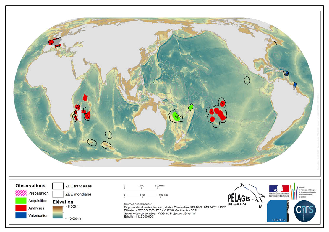
The associated data highlights the spatial influence of the dataset of the type “Visual Observations from an Aerial Platform” from the PELAGIS Observatory. These ranges represent the different areas of study on which the PELAGIS observatory conducted campaigns of visual observations from aerial platforms. Each area of study is associated with at least one campaign, with observers and geographical sectors linked to that campaign. Each sector is associated with bathymetric strips and transects related to each of the strips, with a few exceptions for the Indian Ocean region. Description of fields and values of the attribute tables : (- field name, meaning : value, description of values) - region, area of study specific to the PELAGIS observatory PELAGIS : OI/FRM/ AGFR/SOP/SP, region_lbl - programme, associated programme of which the campaign is a part: REMMOA/PACOMM, REcensement de la Mégafaune Marine par Observation Aérienne/Programme d'Acquisition sur les Oiseaux et Mammifères Marins - idCampagne, abbreviated name of the data collection campaign: OI/SAMM/ ANT/SOP/PF/GUY, Campagne Océan Indien/Suivi Aérien de la Mégafaune Marine/Sud Ouest Pacifique/Polynésie Française/ Guyane française - progress, current state of the campaigns, from collection to scientific optimisation : Preparation/Acquisition/ Analysis/Enhancement, campaign being prepared/under acquisition/being analysed/data enhanced within the context of a scientific publication.
-
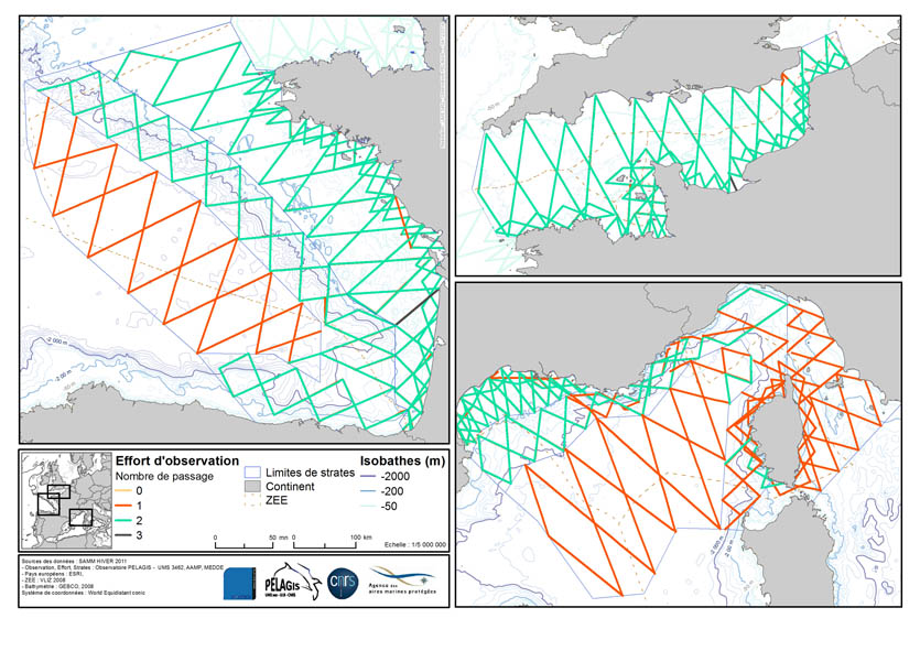
Visual Observations on the Dedicated Aerial Platform - 2. Sampling Programme- PACOMM/SAMM1 and SAMM2
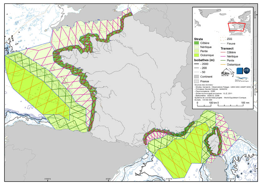
The associated data highlights the sampling programme for the data acquisition campaign of Observation on the Aerial Platform for the SAMM1and SAMM2 campaigns (Aerial Marine Megafauna Monitoring) conducted by the PELAGIS observatory (UMS 3462 ULR/CNRS). The sampling plan is composed of preestablished sampling strata and transects. These were drawn up according to the specific characteristic of the study area “Mainland France”, or FrM. Description of fields and values of allocation tables: : ( - field name, meaning: value, description of values) region char 5 Study area region_lbl char 50 labelled study area idCampagne (survey) char 15 Name of the campaign programme char 20 Programme name sector char 10 Sampling sector short ID strate char 5 Sampling strata short ID strate_lbl char 15 Labelled sampling strata areaKM double Strata surface area transect_name char 10 transect sampling length_km double Transect length start_x double Coordinates of the start of transect x in decimal degree start_y double Coordinates of the start of transect y in decimal degree end_x double Coordinates of the end of transect x in decimal degree end_y double Coordinates of the end of transect y in decimal degree
-
The observation of ecosystems by Ifremer's Fisheries Information System (SIH) is based on a network of sea cruises. It aims to assess the state of stocks of the various species fished in France and Europe. It also enables the characterisation of the marine ecosystem in which the populations evolve. 23 scientific cruises take place each year at sea, enabling data to be collected for more than 30 years for the oldest. Thanks to the use of standardised fishing gear, the data acquired each year on board scientific vessels or professional fishing vessels contribute to the calculation of the index of abundance, with thousands of fish taken during timed trawls. The fish are measured and their age is assessed by measuring their otoliths (small bones located in the inner ear of the fish).
-
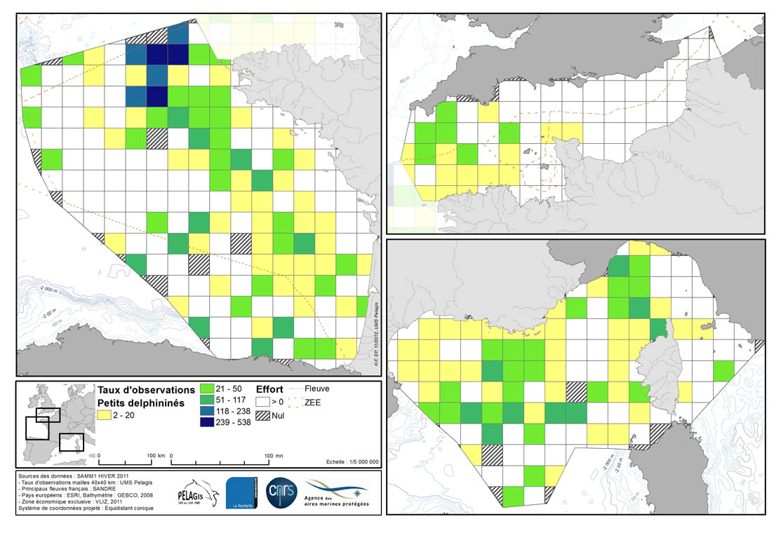
Occurrence rate by observation number for 100km of effort in each 40km mesh in the French mainland EZE in the winter of 2011/2012 and the summer of 2012. Description of the attribute table: survey : campaign Type: observation type Mesh: mesh size in kilometers _no_maille : mesh number The following fields correspond to the calculation of the occurrence rate for the observation number for 1000km of effort for each species or group of species : - [marsouin] common porpoise - [grdDauph] bottlenose dolphin - [lagenor] White-beaked dolphin - [pttDelph] : common dolphin and Striped dolphin - [globiceph] : Long-finned pilot whale + Risso's dolphin - [cakobab] : Sperm whale+ kogias + Beaked whales - [balenopt] : Fin whale + Minke whale + blue whale - [phoque] seal (grey + harbour)
-
The definitive coastal information system, Quadrige stores coastal observation and monitoring network data. In order to manage coastal monitoring data, Ifremer developed the Quadrige² information system. Quadrige is one element of the Water Information System (SIE) http:// www.eaufrance.fr, et à ce titre, contribue aux travaux du Secrétariat d'Administration National des Données Relatives à l'Eau (SANDRE) http://www.sandre.eaufrance.fr. Quadrige Marine Zones is a reference source unique to the Quadrige system. It is used to break down the coast of the French mainland and overseas territories into large areas and to connect each one with observation and monitoring locations.