 Mon GéoSource
50000
Type of resources
Available actions
Topics
INSPIRE themes
Keywords
Contact for the resource
Provided by
Years
Formats
Representation types
Update frequencies
status
Scale
Resolution
-
Validated and aggregated data from current profilers measured continuously by hull-mounted ADCPs (Acoustic Doppler Current Profiler).
-
-
-
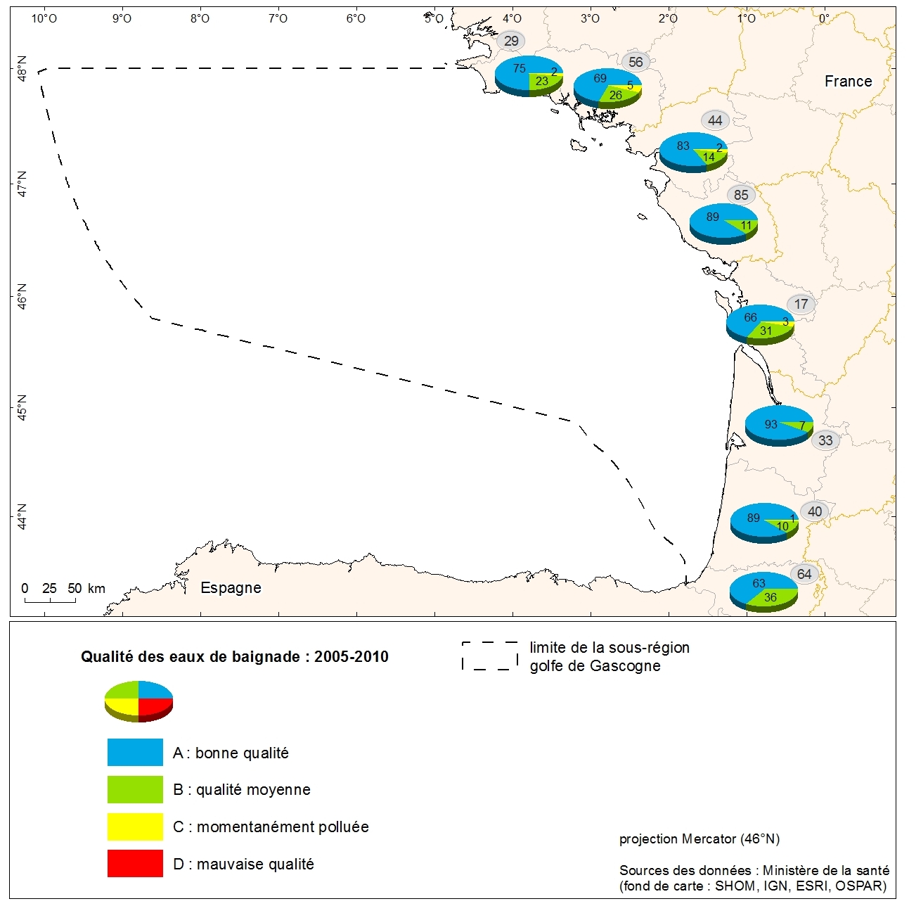
Grading the quality of metropolitan coastal bathing waters in 2010 from the Department of Health. Data collected from the Ministry of Health as part of the initial assessment of the MSFD. Referent expert: Aurélie Blanck.
-
Zones corresponding to the delimitation of major watersheds and related marine areas in the Seine-Normandy basin for the assessment of pressures on the different water masses on the Normandy coast and marine sub region English Channel - North Sea. Nutrient discharges from industries and communities.
-
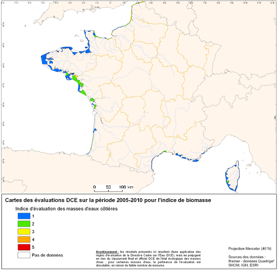
Under the EU Water Framework Directive (2000/60/EC), among the biological parameters involved in the assessment of coastal water bodies, the quality element "phytoplankton" is defined. This indicator Phytoplankton is made up of several indexes including a biomass index and an abundance index. Oxygen balance appearing among the elements of physicochemical quality selected for the classification of the ecological state of coastal water bodies. The quality element "benthic invertebrates" is also part of the biological parameters involved in the assessment of these water bodies.
-
Physico-chemical monitoring stations are part of a network under the responsibility of the water agencies. Regarding the scope of strict thematic contribution "Hydrology," the monitoring stations do not come into account because they only measure the physico-chemical quality of the rivers. These stations are used only for calculations under fluvial inputs of pollutants / nutrients.
-
Bathymétrie du fleuve Manche, au large de l'île Vierge, Plouguerneau (campagne SEDIMANCHE 2, 1993). Les données ont été acquises par le sondeur multifaisceau EM1000 du N/O Le Suroît, lors de la campagne Sedimanche 2 en 1993. Le pas de la grille est de 50 mètres (WGS84, projection Mercator latitude 49°N, méridien central 4,683334°O). Référence verticale : niveau moyen des mers Description de la campagne : LERICOLAIS Gilles, AUFFRET Jean-Paul (1993) SEDIMANCHE 2 cruise, RV Le Suroît, https://doi.org/10.17600/93000030 Référence bibliographique : Lericolais Gilles (1997). Evolution du fleuve Manche depuis l'oligocène : stratigraphie et géomorphologie d'une plateforme continentale en régime périglaciaire. PhD Thesis, Unersité Bordeaux I. https://archimer.ifremer.fr/doc/00034/14504/
-
Cette carte des peuplements benthiques de la région de Roscoff a été réalisée d’après une carte extraite de la thèse de Louis Cabioch (1968, Station biologique de Roscoff) : "Contribution à la connaissance des peuplements benthiques de la Manche occidentale" publiée en 1968 dans les Cahiers de biologie marine, tome IX, cahier 5 suppl. Ces données ont été numérisées en 2003 et une harmonisation avec la typologie EUNIS a été effectuée en 2006 dans le cadre des projets REBENT et Interreg-MESH, avec l'expertise de Frank Gentil, de la Station Biologique de Roscoff.
-
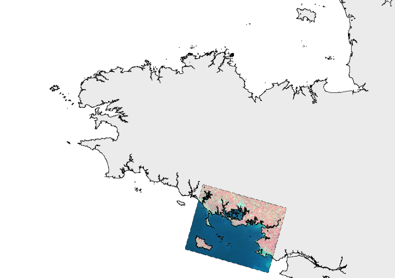
L'image SPOT du 20 avril 2007, qui s'étend du sud de la Ria d'Etel à Pornichet,en passant par la Baie de Vilaine et les Îles de Houat, Hoëdic et Belle-Île (Morbihan) a été traitée par le CEVA dans le cadre du REseau de surveillance BENThique (REBENT) en 2007 en vue du suivi de la couverture en Fucales des côtes bretonnes. Cette image a été acquise à une résolution de 10 m. Les résultats de ces traitements sont : - une cartographie de la couverture végétale en fucales dans la zone intertidale basée sur un indice de couverture végétale (VCI). - des comparaisons multi-dates basées sur le calcul de différentiel de VCI afin de mettre en évidence des variations spatio-temporelles du couvert végétal en fucales : comparaison avec les Images Spot du 7 octobre 1986 et du 3 septembre 2004.