Mon GéoSource
imageryBaseMapsEarthCover
Type of resources
Available actions
Topics
INSPIRE themes
Keywords
Contact for the resource
Provided by
Years
Formats
Representation types
Update frequencies
status
Service types
Scale
Resolution
-
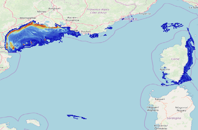
Data on physical impact intensity caused by trawling (bottom otter trawl, twin bottom otter trawl, dredges) estimated from VMS (Vessel Monitoring System) data cross-referenced with the Community Fishing Fleet Register and, for French vessels, with the landing data between 2008 and 2020. The data is constituted of 14 rasters in a resolution of 1’x1’ (13 annual abrasion rasters between 2008 and 2020 and 1 raster representing the 90th percentile of inter-annual abrasion). The abrasion is expressed in swept area ratio per year for each layer. This work enabled the study of the trawling impact on benthic communities in the Gulf of Lions and Corsica. The objective was to better describe the spatial and temporal repartition of trawling in this area and its potential impact on benthic habitats.
-
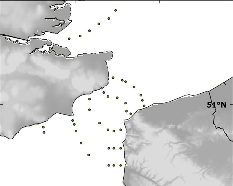
Localisation of the 39 sampled sites done during the BCD survey in April 1999.
-

Cette donnée n’est pas une donnée brute comme nous avons l’habitude de mettre à disposition, néanmoins il nous semble important que ce type d’information soit accessible aux citoyens. Il s’agit de l’orthophoto de la ville de Montpellier réalisée en 2011. Une orthophoto se définit simplement comme une prise de vue aérienne de la surface terrestre. Le document d’origine est découpé en plus de 230 dalles, ces dernières ont été assemblées en une seule dalle pour un confort de lecture. Le résultat est de fait un peu moins précis que le document d’origine, mais reste de très bonne qualité (précision 16 cm, en Lambert 93). Il s’agit quand même d’un document de 3.6 go datant de 2011. Ce document est téléchargeable sous le format .ecw (Enhanced Compression Wavelet) qui nécessite un logiciel particulier pour être ouvert. Nous pouvons vous conseiller Quantum GIS qui est une solution SIG en open source. Une fois installé, il vous faudra faire : « Ajouter une couche raster ».
-

Le RGE® est constitué de 4 composantes : orthophotographique, topographique et altimétrique, parcellaire, adresse et altimétrique. OPenIG (ex SIG L-R) diffuse cette donnée aux adhérents et sur le territoire régional. L'existence de cette fiche de métadonnées est liée aux contraintes de l'IDG locale. Les produits présents dans ce téléchargement : - BD TOPO® Tous thèmes - Edition avril 2019 Version 3 (Ed. 19.1) - BDADRESSE® : Edition avril 2019 (Ed. 19.1) - ADRESSE PREMIUM : V2.1 Edition Novembre 2018 (Ed. 18.2) - RGE ALTI® 5m - BD PARCELLAIRE® : Ariège (09) 2016 Hautes Pyrénées (65) 2017 Tarn et Garonne (82) 2017 Lot (46) 2018 Aveyron (12) 2018 Gers (32) 2017 Lozère (48) 2014 Gard (30) 2017 Haute Garonne (31) 2018 Pyrénées Orientales (66) 2016 Hérault (34) 2017 Aude (11) 2017 Tarn (81) 2018
-
Périmètre des zones d'aménagement à vocation d'habitat et créées par subdivisions parcellaires sur les zones à urbaniser (nouvelle ou requalification de sites anciens)
-
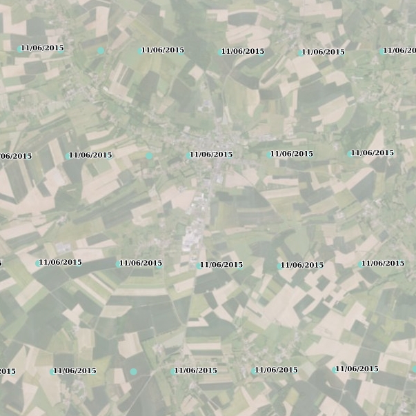
Localisation, dates et altitudes de chacune des 16 158 prises de vues aériennes de l'orthophotographie Nord-Pas de Calais 2012-2013 produites par la Plateforme Publique de l'Information Géographique (PPIGE) Nord-Pas de Calais.