 Mon GéoSource
fond marin
Type of resources
Available actions
INSPIRE themes
Provided by
Years
Formats
Representation types
Update frequencies
status
Scale
Resolution
-
Bathymetry of the Crozet Islands, spatial resolution 100 meters. This Digital Terrain Model is a compilation of bathymetric data from several sources. Vertical reference : observed sea level Data process : Loubrieu Benoit, Pierre Delphine, Biville Romain, Le Duff Mathilde (2013). Digital Terrain Model for the HA04 hydroacoustic station, Crozet Islands, France. CB/GM/CTDI-BL2013-01 The data come from the cruises : - SCHLICH Roland (1998) KERIMIS-MD109 cruise, RV Marion Dufresne, https://doi.org/10.17600/98200010 - HUMLER Eric (2001) MD 121 / SWIFT cruise, RV Marion Dufresne, https://doi.org/10.17600/1200030 - METZL Nicolas, PIERRE Catherine (2001) VT 51 / OISO 6 cruise, RV Marion Dufresne, https://doi.org/10.17600/1200010 - ASLANIAN Daniel, HUMLER Eric, MICHEL Elisabeth (2002) MD 125 / SWIFT BIS-CARHOT cruise, RV Marion Dufresne, https://doi.org/10.17600/2200020 - MICHEL Elisabeth (2004) MD 136 / VIGO cruise, RV Marion Dufresne, https://doi.org/10.17600/4200110 - ROEST Walter (2005) MD 150 /DELCANO RISE-KERGUEPLAC2 cruise, RV Marion Dufresne, https://doi.org/10.17600/5200060 - VIALLY Roland, BRUNET Christian, ROYER Jean-Yves (2008) MD 165 / KERGUEPLAC 3 cruise, RV Marion Dufresne, https://doi.org/10.17600/8200010 - ROEST Walter, JOHNSON Sean (2010) MD176 Discovery Ridge-CrozetPlac cruise, RV Marion Dufresne, https://doi.org/10.17600/18001444 - CROSTA Xavier (2019) MD 218 / CROTALE cruise, RV Marion Dufresne, https://doi.org/10.17600/18000886 + transits of the R/V Marion Dufresne MD202 (2016) et MD207 (2017)
-
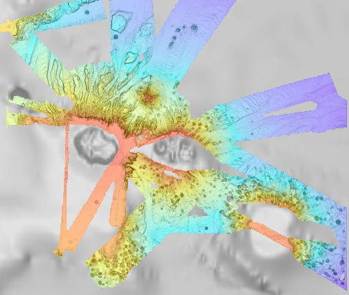
Bathymétrie du pockmark Regab (campagne WACS, 2011), au pas de 25 centimètres. Ce jeu de données est un Modèle Numérique de Terrain bathymétrique, issu de l'acquisition acoustique du sondeur multifaisceaux Resonn Seabat 7125 du N/O Pourquoi Pas?, lors de la campagne WACS, du 26 janvier au 25 février 2011. Description de la campagne : OLU Karine (2011) WACS cruise, RV Pourquoi pas ?, https://doi.org/10.17600/11030010 Bibliographie : - Marcon Yann, Ondreas Helene, Sahling Heiko, Bohrmann Gerhard, Olu Karine (2014). Fluid flow regimes and growth of a giant pockmark. Geology, 42(1), 63-66. Publisher's official version : https://doi.org/10.1130/G34801.1 , Open Access version : https://archimer.ifremer.fr/doc/00186/29731/ - Picot M., Droz L., Marsset Tania, Dennielou Bernard, Bez M. (2016). Controls on turbidite sedimentation: Insights from a quantitative approach of submarine channel and lobe architecture (Late Quaternary Congo fan). Marine And Petroleum Geology, 72, 423-446. Publisher's official version : https://doi.org/10.1016/j.marpetgeo.2016.02.004 , Open Access version : https://archimer.ifremer.fr/doc/00312/42285/
-

Map of surficial sediments in the English Channel area known as "Larsonneur."
-
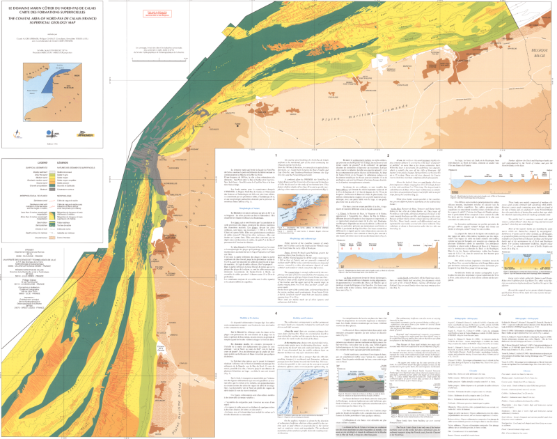
Scan de la carte des formations superficielles du domaine marin côtier du Nord Pas de Calais (édition 1995 ; échelle 1/100000). Les campagnes océanographiques à l'origine de la réalisation de cette carte sont : Granor83 en 1983, Granor84 en 1984, Granor85 en 1985, Pascal en 1986, Focal88 (Focal1) et Focal (Focal2) en 1988.
-

Ce jeu de données provient de la digitalisation de la carte des formations superficielles sous-marines aux abords de Flamanville (édition 2005 ; échelle 1/15000). Les campagnes océanographiques à l'origine de la réalisation de cette carte sont : Sonarman 1 en 1983, Flamenco Flamanville en 1984, Golfe en 1985 et Geobase 1 en 1987.
-

Map of surficial sediments of the northern continental shelf of the Bay of Biscay at 1:500000 by Bouysse P. (coord.), Lesueur P. and Klingebiel A., 1986, conducted jointly by the BRGM and Ifremer.
-
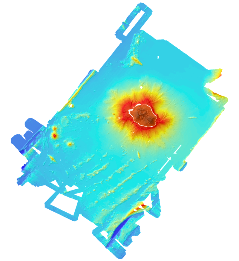
Bathymetric and topographic model of the island of La Réunion. Topography is from IGN data. Bathymetry is derived from the multibeam data acquired during the campaigns Forever (2006, EM12D sounder) Eroder1 (2006, EM120 sounder) and Eroder2 (2007, EM120 sounder). The grid spacing is 300m.
-

Scan de la Carte géomorphologique du précontinent languedocien, du Cap Bagur au Cap d'Agde, au 1/250 000, par J.C. Aloïsi, H. Got et A. Monaco ; dessins du Musée Océanographique de Monaco. S'adresser à l'Université de Perpignan Via Domitia, laboratoire CEFREM, pour toute demande d'accès à cette donnée.
-
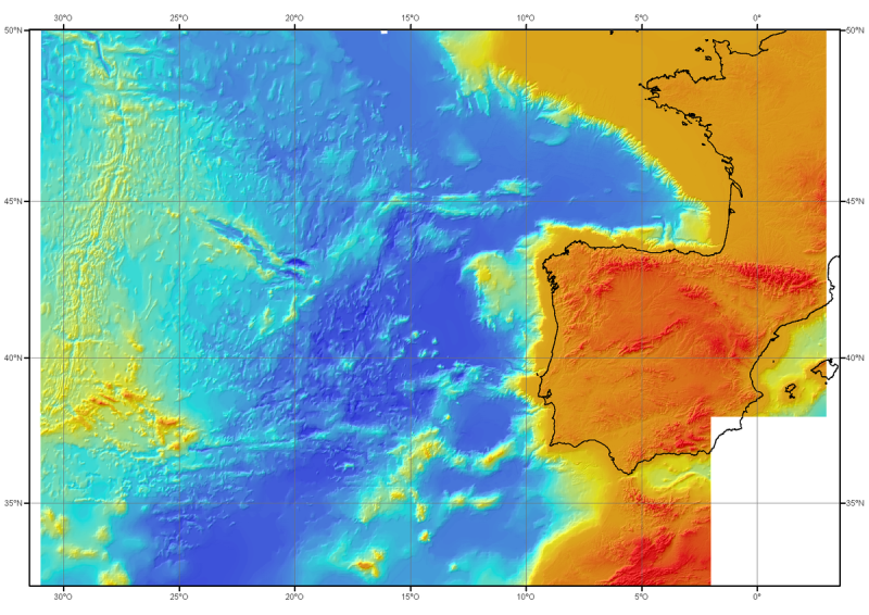
Bathymetric model (DTM) of the North-East Atlantic, generated from conventional multibeam bathymetry data, prior to the year 2000. The grid spacing is 1000 meters. Bibliographic reference : Sibuet J.C. & al., (2004) - Carte bathymétrique de l'Atlantique nord-est et du golfe de Gascogne : implications cinématiques. Bull. Soc. géol. Fr.T. 175, n°5, pp. 429-442
-
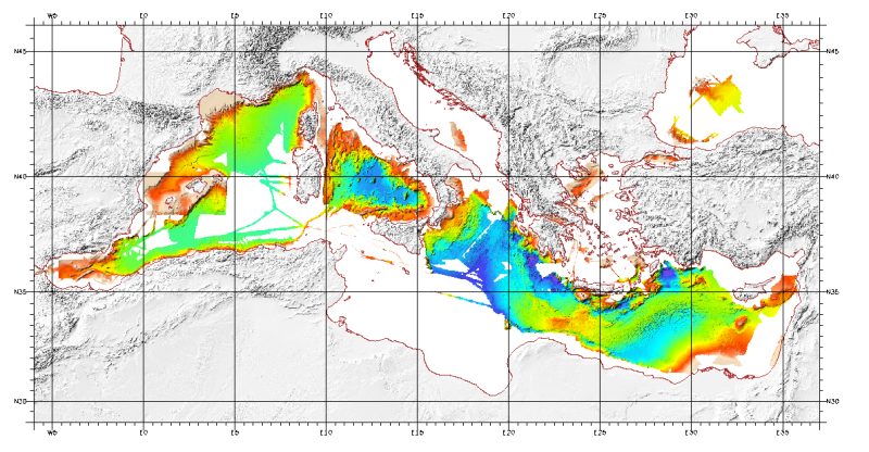
Bathymetric model (DTM) of the Mediterranean. MediMap group. Bathymetry data acquired by multibeam sounders during campaigns Almofront.leg1 and Almofront.leg2, Almofront, Bretane, Seamewe2, Heralis, Medee, Anaxiprobe, Almofront2 - leg1 and leg2, Prismed2, Marmara, Fanil, Tvic5 et 6, Progres, Maradja, Blac, Nautinil, Medor-Simed1 / 2 / 3 / 4 / 5, Maradja2, Sardinia, Prisme, Assemblage and Thertou. Integration of partner organizations DTM. This DTM is available at two cell sizes : 500 m and 1000 m.