 Mon GéoSource
/Overseas France/Antilles
Type of resources
Available actions
Topics
INSPIRE themes
Keywords
Contact for the resource
Provided by
Years
Representation types
Update frequencies
status
Scale
-
IOWAGA sea-states hindcast database generated by the wave model WAVEWATCH-III and forced by CFSR winds on the North East Atlantic grid over 1990-2012 period.
-

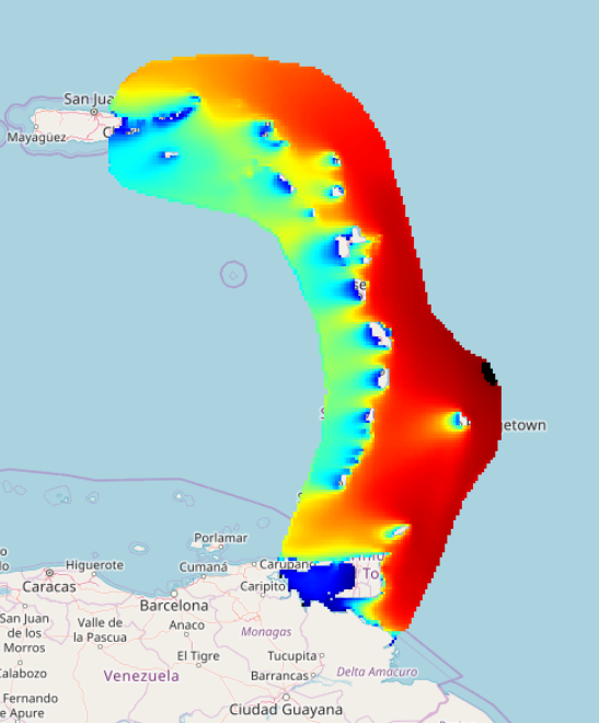
Bathymetry of the French Guiana margin: the digital terrain model results from data compilation of 3 multibeam surveys conducted on the French research vessel RV L’Atalante. Grid resolution is 250 m. The DTM was processed as part of the French national program (EXTRAPLAC) for the delineation of the outer limit of the continental shelf beyond 200 nautical miles. - Guyaplac, 2003, R/V Atalante: Main source of the DTM was a cruise funded by the French National programme EXTRAPLAC. https://doi.org/10.17600/3010050 - Lobestory, 2004, R/V L'Atalante, https://doi.org/10.17600/4010030 - Cither1, 1993, R/V L'Atalante, https://doi.org/10.17600/93000010
-
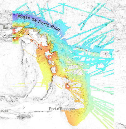
Bathymetry – Lesser Antilles volcanic arc: compilation of multibeam data, grid resolution 1/16 arc minute, 2020. Restriction : the DTM largely overlaps national EEZ. The entire product cannot be freely disseminated. Processing : Since the beginning of the 1990s, the scientific exploration of the West Indian arc has provided the opportunity for regular acquisition of multibeam bathymetry. About twenty scientific cruises and valued transits feed a remarkable database and offer a wide bathymetric coverage of this geological structure. They were assembled to produce a bathymetric model of the entire region. Multibeam data were controlled and processed with the Ifremer Globe software. A similar processing flow is applied to each dataset: - Selection of relevant profiles for acoustic coverage of the study area - Automatic and manual filtering of outliers and erroneous data - Control of overlapping zones - Production of a digital terrain model. Depth layer is calculated as the average of soundings in each pixel. All DTMs are merged into a unique DTM for the area. The final product is a double-layer raster at 1/16 minute steps (~ 100 m), a bathymetric layer and data source identifier layer. Data processing is described in this specific report : "Talbot Sophie (2019). Evaluation d'une méthodologie pour la compilation de données bathymétriques." https://w3.ifremer.fr/archimer/doc/00613/72480/ Multibeam data from scientific cruises from 1992 to 2017: - ESCARTIN Javier, LE FRIANT Anne, FEUILLET Nathalie (2017) SUBSAINTES cruise, RV L'Atalante, https://doi.org/10.17600/17001000 - MARCAILLOU Boris, KLINGELHOEFER Frauke (2016) ANTITHESIS 3 cruise, RV Pourquoi pas ?, https://doi.org/10.17600/16001700 - MARCAILLOU Boris, KLINGELHOEFER Frauke (2013) ANTITHESIS LEG1 cruise, RV L'Atalante, https://doi.org/10.17600/13010070 - FEUILLET Nathalie (2009) GWADASEIS cruise, RV Le Suroît, https://doi.org/10.17600/9020020 - LEBRUN Jean Frédéric (2009) KASHALLOW 2 cruise, RV Le Suroît, https://doi.org/10.17600/9020010 - LAIGLE Mireille, LEBRUN Jean Frédéric, HIRN Alfred (2007) SISMANTILLES 2 cruise, RV L'Atalante, https://doi.org/10.17600/7010020 - PATRIAT Martin (2007) ANTIPLAC cruise, RV L'Atalante, https://doi.org/10.17600/7010010 - DEPLUS Christine, BOUDON Georges (2002) CARAVAL cruise, RV L'Atalante, https://doi.org/10.17600/2010030 - MASCLE Alain (2002) CARAMBA cruise, RV L'Atalante, https://doi.org/10.17600/2010010 - DEPLUS Christine (1998) AGUADOMAR cruise, RV L'Atalante, https://doi.org/10.17600/98010120 - LE PICHON Xavier, LALLEMANT Siegfried (1992) MANON cruise, RV L'Atalante, https://doi.org/10.17600/92000211 Valued transits Leve_smf (https://doi.org/10.17600/16010800), Lobestory (https://doi.org/10.17600/4010030), Guyaplac (https://doi.org/10.17600/3010050), TRtoufdf, transit from Toulon to Fort-de-France Dormasis (https://doi.org/10.17600/92000411), Faranaut/15N (https://doi.org/10.17600/92000311), Fara-Seadma1 (https://doi.org/10.17600/91004411), Fara Published DTM : Ryan, W.B.F., S.M. Carbotte, J.O. Coplan, S. O'Hara, A. Melkonian, R. Arko, R.A. Weissel, V. Ferrini, A. Goodwillie, F. Nitsche, J. Bonczkowski, and R. Zemsky (2009), Global Multi-Resolution Topography synthesis, Geochem. Geophys. Geosyst., 10, Q03014, doi: 10.1029/2008GC002332
-
REPHY is a national network covering the coast of the French mainland along with that of three of its overseas departments: Martinique, Guadeloupe and Reunion Island. The aims are as follows: - to observe all phytoplankton species in the coastal waters and to monitor events such as coloured water, exceptional blooms, and the proliferation of species which are toxic or disruptive to marine fauna, - Particularly to monitor species producing toxins which are dangerous to shellfish consumers . These objectives are complementary, as the regular monitoring of all phytoplankton species makes it possible to detect known toxic and invasive species, but also to detect potentially toxic species. It is the presence of these toxic species in the water which triggers the monitoring of toxins in shellfish. The mission of REPHY is to monitor shellfish in their natural environment (such as parks and deposits). For shellfish removed from marine environments (that is to say in shellfish logistics establishments or on markets prior to export), national monitoring and control plans are organised by the General Food Directive at the French Ministry of Agriculture. Analyses are performed by the accredited departmental veterinary laboratories as organised by the National Reference Laboratory from the French Food Safety Agency.