 Mon GéoSource
Habitats and biotopes
Type of resources
Available actions
Topics
INSPIRE themes
Keywords
Contact for the resource
Provided by
Years
Formats
Representation types
Update frequencies
status
Scale
Resolution
-
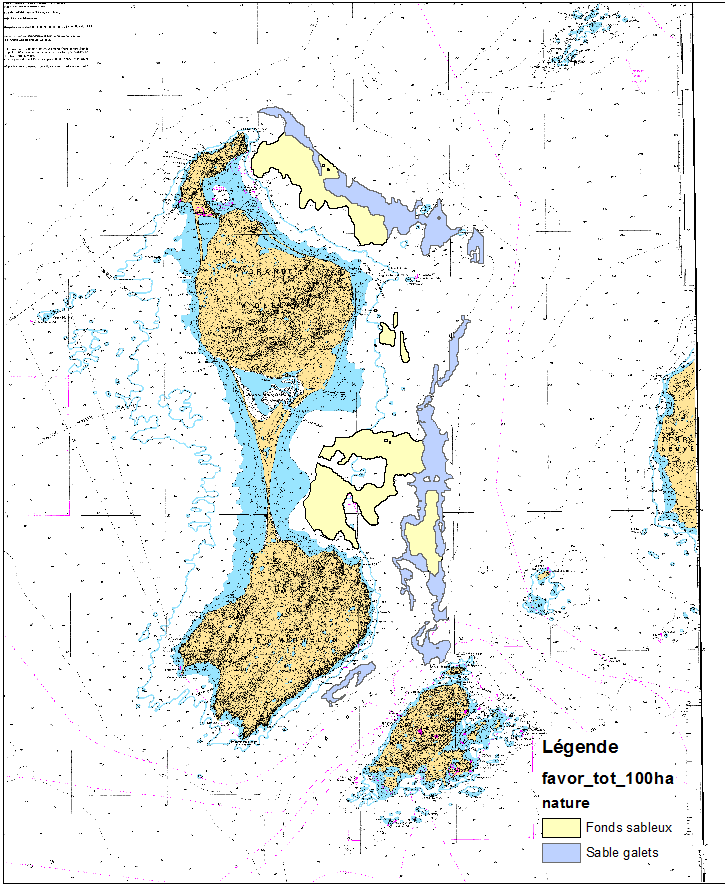
This data set was obtained during 2 ENVISION-IFREMER field campaigns carried out in 2007 and 2011 to sustain a Pectinid aquaculture project. This project was co-funded by ODEADOM and the public collectivity of Saint Pierre et Miquelon. Potential areas for further aquaculture exploitation and development on the Eastern coast of Saint Pierre et Miquelon.
-
This data set was collected during 2 ENVISION-IFREMER field campaigns carried out in 2007 and 2011 to sustain a Pectinid aquaculture project. This was co-funded by ODEADOM and the public collectivity of Saint Pierre et Miquelon. This work aims to assess new seeding and rearing areas for the King scallop Placopecten magellanicus through a site selection process using the bottom type mapping data set obtained during the 2 ENVISION-IFREMER field campaigns. Furthermore, new estimates of potental scallop production is produced by this data treatment.
-
The mapping of pockmark habitats (cold fluid emissions) off the coast of Congo was carried out by Ifremer's Deep-Sea Laboratory as part of the WACS cruise. The method used for this habitat mapping is based on the preliminary analysis of videos acquired with the ROV Victor 6000 during the oceanographic cruise: WACS (from 26/01/2011 to 25/02/2011, mission leader: Karine OLU). The habitats were described at the finest level of analysis and then classified according to the EUNIS typology (https://www.eea.europa.eu/data-and-maps/data/eunis-habitat-classification-1). Data published in: Marcon, Y., H. Sahling, A.-G. Allais, G. Bohrmann and K. Olu (2014a). Distribution and temporal variation of mega-fauna at the Regab pockmark (Northern Congo Fan), based on a comparison of videomosaics and geographic information systems analyses." Marine Ecology 35(1): 77-95. doi: 10.1111/maec.12056
-
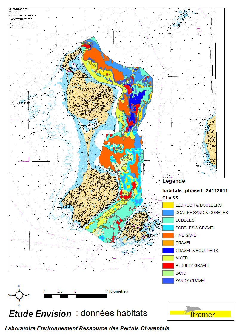
These data were collected during the 2007 and 2011 ENVISION-Ifremer campaigns to sustain a R & D project focusing on the Pectinid aquaculture development. This project was co-funded by the Saint Pierre et Miquelon public body and ODEADOM. This work aims to assess and select new potential rearing areas for the King scallop Placopecten magellanicus by using bottom type data resulting from 2 mapping campaigns carried out in 2007 and 2011 on the Eastern coast of Saint Pierre et Miquelon archipelago.
-
The mapping of habitats off the coast of Congo was carried out by the Ifremer Deep-Sea Laboratory as part of the ANR CONGOLOBE project (2011-2015, coordinator Christophe RABOUILLE). The method used for this habitat mapping is based on the preliminary analysis of images acquired with the ROV Victor 6000 during two oceanographic campaigns: WACS (from 26/01/2011 to 25/02/2011, mission chief: Karine OLU) and CONGOLOBE (from 11/12/2011 to 12/01/2012, mission chief: Christophe RABOUILLE). The habitats were described at the finest level of analysis and then classified according to the EUNIS typology (https://www.eea.europa.eu/data-and-maps/data/eunis-habitat-classification-1). Data published in: Sen, A., B. Dennielou, J. Tourolle, A. Arnaubec, C. Rabouille and K. Olu (2017). Fauna and habitat types driven by turbidity currents in the lobe complex of the Congo deep-sea fan. Deep-Sea Research Part Ii-Topical Studies in Oceanography 142: 167-179. http://dx.doi.org/10.1016/j.dsr2.2017.05.009
-
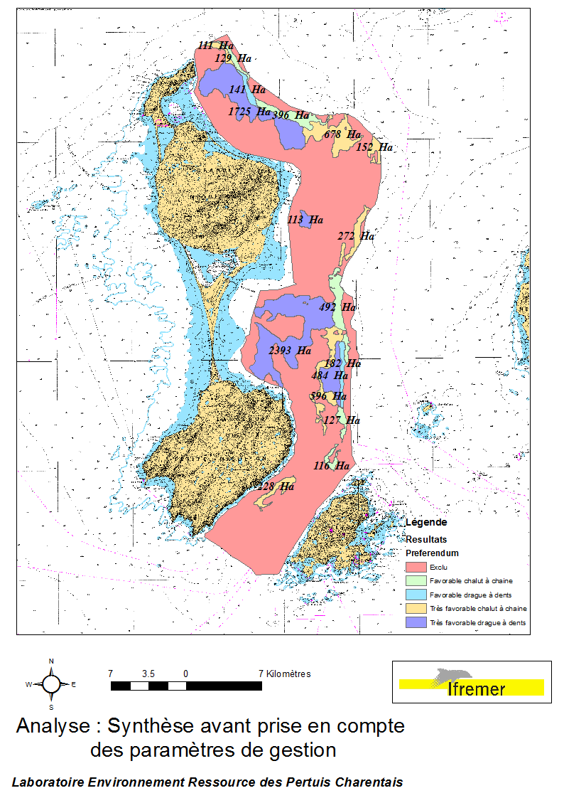
This data set was obtained during 2 ENVISION-IFREMER field campaigns carried out in 2007 and 2011, to sustain a R & D project aimed to develop pectinid aquaculture. This project was co-funded by the St Pierre et Miquelon public collectivity and ODEADOM. This represents a synthesis of spatial analysis based upon multi-criteria to assess future seeding and rearing areas for King scallop Placopecten magellanicus on the Eastern coast of Saint Pierre et Miquelon.
-
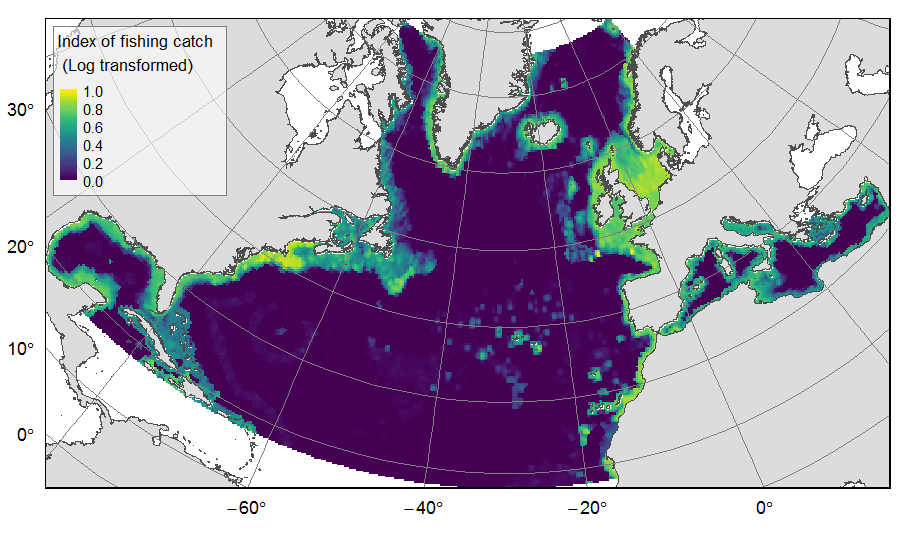
Distribution of catch from deep-sea impacting fishing on the North Atlantic (18°N to 76°N and 36°E to 98°W), for the period 2010-2015. The average of yearly fishing catch for the period 2010-2015 is displayed as an index on the ATLAS grid of 25km * 25km resolution. Source data originated from the Global Fisheries Landings V4.0 database. The dataset was filtered to select only the fishing gears that have an impact on large areas of the seafloor (dredges, bottom trawls, and Danish seines). Within each cell, all remaining catch records were summed to get the total catch rate of the considered year. This dataset was built to feed a basin-wide spatial conservation planning exercise, targeting the deep sea of the North Atlantic. The goal of this approach was to identify conservation priority areas for Vulnerable Marine Ecosystems (VMEs) and deep fish species, based on the distribution of species and habitats, human activities and current spatial management.
-
This mapping of marine biocenoses between 0 and 50m depth covers 75km of coastline between Antibes and Cap d'Ail.
-
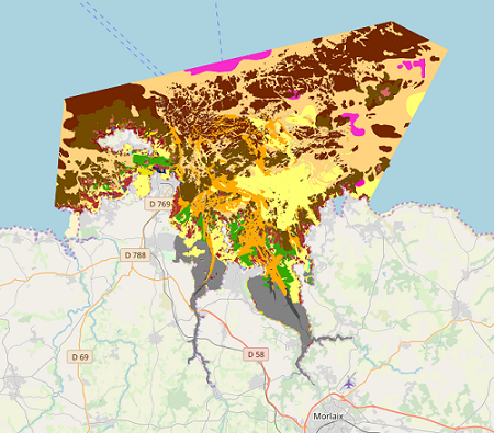
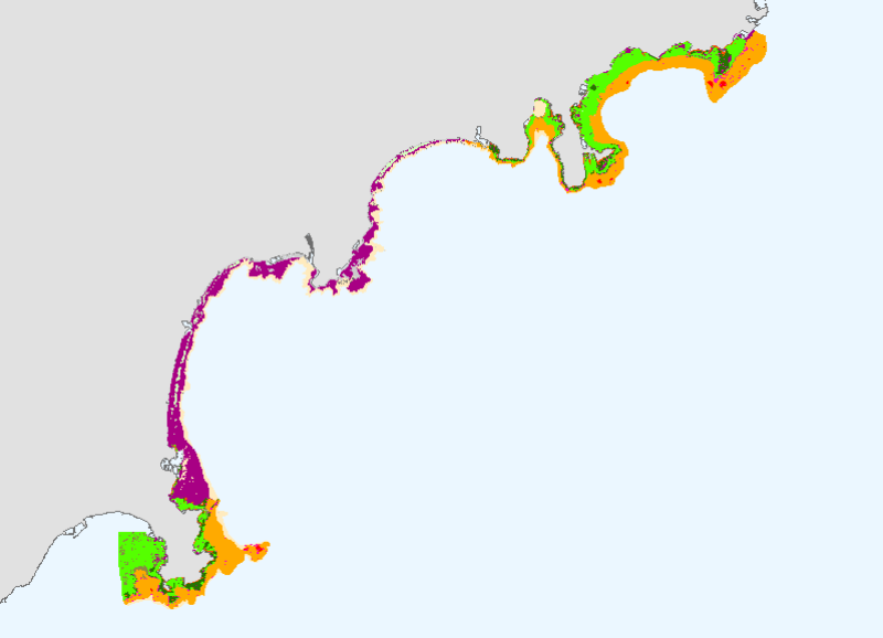
Map of benthic habitat synthesis of the Natura 2000 site FR5300015 - Bay of Morlaix is the result of the fusion and harmonization of five cartographic data. They were generated according to mapping strategies, interpretation scales and on the basis of different cartographic supports.
-
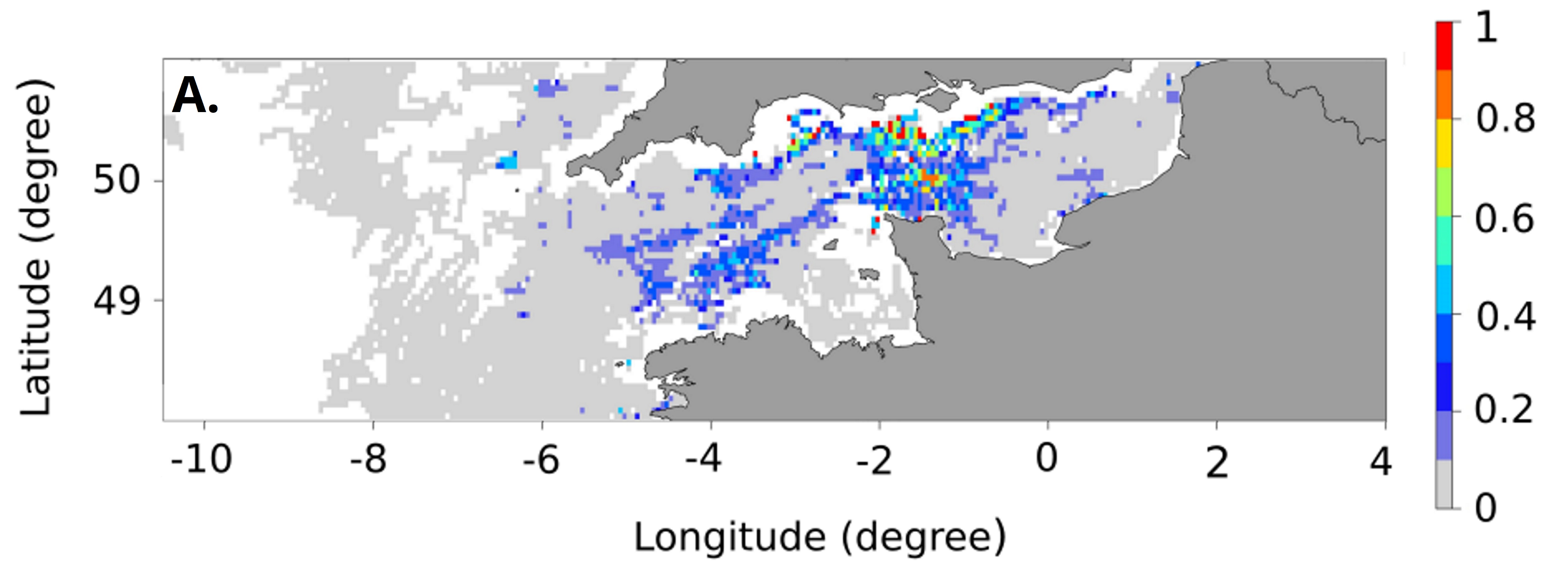
These maps represent the monthly probability of being a seabass spawning area for each month of the spawning season (January to April), and the mean probability of being a seabass spawning area over all spawning months in the English Channel - Celtic Sea. These probability maps were calculated by performing a geostatistical analysis of fishing data from geolocated vessels, and have a spatial resolution of 3 by 3 nautical miles.