 Mon GéoSource
2018
Type of resources
Available actions
Topics
INSPIRE themes
Keywords
Contact for the resource
Provided by
Years
Formats
Representation types
Update frequencies
status
Scale
Resolution
-
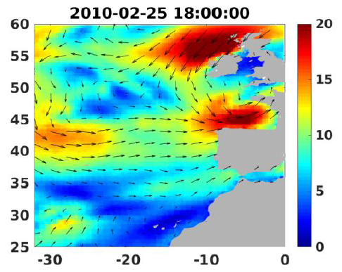
Wind analyses, estimated over the North Atlantic Ocean with a focus on some specific regions, are one the main ARCWIND (http://www.arcwind.eu/) project deliverables. They are estimated from various remotely sensed wind observations in combination with numerical model (WRF), with regular space (0.25deg in latitude and longitude), and time (00h:00, 06h:00, 12h:00, 18h:00 UTC), and based the method described in (Bentamy A., A. Mouche, A. Grouazel, A. Moujane, M. A. Ahmed. (2019): Using sentinel-1A SAR wind retrievals for enhancing scatterometer and radiometer regional wind analyses . International Journal Of Remote Sensing , 40(3), 1120-1147 . https://doi.org/10.1080/01431161.2018.1524174).
-
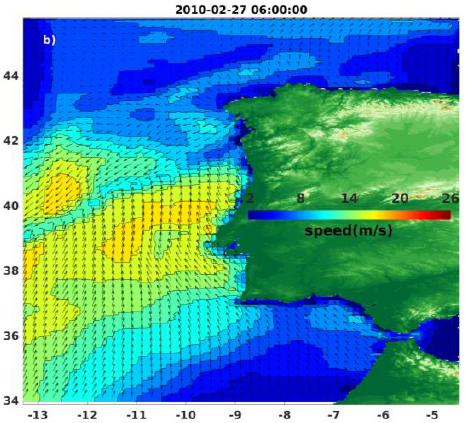
Wind analyses, estimated over the North Atlantic Ocean with a focus on some specific regions, are one the main ARCWIND (http://www.arcwind.eu/) project deliverables. They are estimated from various remotely sensed wind observations in combination with numerical model (WRF), with regular space (0.125deg in latitude and longitude), and time (00h:00, 06h:00, 12h:00, 18h:00 UTC), and based the method described in (Bentamy A., A. Mouche, A. Grouazel, A. Moujane, M. A. Ahmed. (2019): Using sentinel-1A SAR wind retrievals for enhancing scatterometer and radiometer regional wind analyses . International Journal Of Remote Sensing , 40(3), 1120-1147 . https://doi.org/10.1080/01431161.2018.1524174).
-

Habitat typology obtained from the statistical analysis of underwater video data collected from the STAVIRO autonomous unbaited video technique (AMBIO project)
-
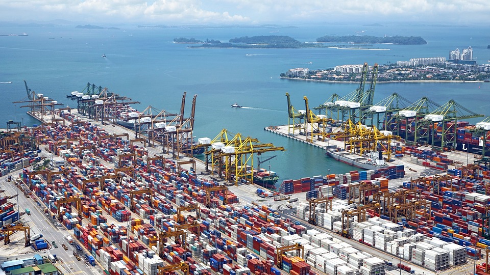
World list of seaports. In its 2021 version, the repository includes 13709 ports for 187 countries. The list of seaports has been drawn up on the basis of the information available in the European reference system of places used in the framework of the Common Fisheries Policy and, more particularly, by the Electronic Recording and Reporting System (ERS), the list of ports identified by the UNECE (2021-1). An assessment of the infrastructures present along the coastline made it possible to identify other ports that were not listed. Each geographical position has been verified with Google Earth in WGS84. Each port is associated with information relating to the country (ISO 3 coding), the UNECE or ERS 5-character coding, the name, the geographical position in WGS84 (latitude and longitude), the status of the port indicating whether it is referenced by Unece (UNECE), by the EU/ERS (ERS) or by both (UNECE/ERS) In case the port is not referenced by UNECE or ERS, the status is N/A. For French ports, the reference system integrates the ports of the French overseas departments and territories with the national codification. Inland ports have also been integrated in 2021.
-

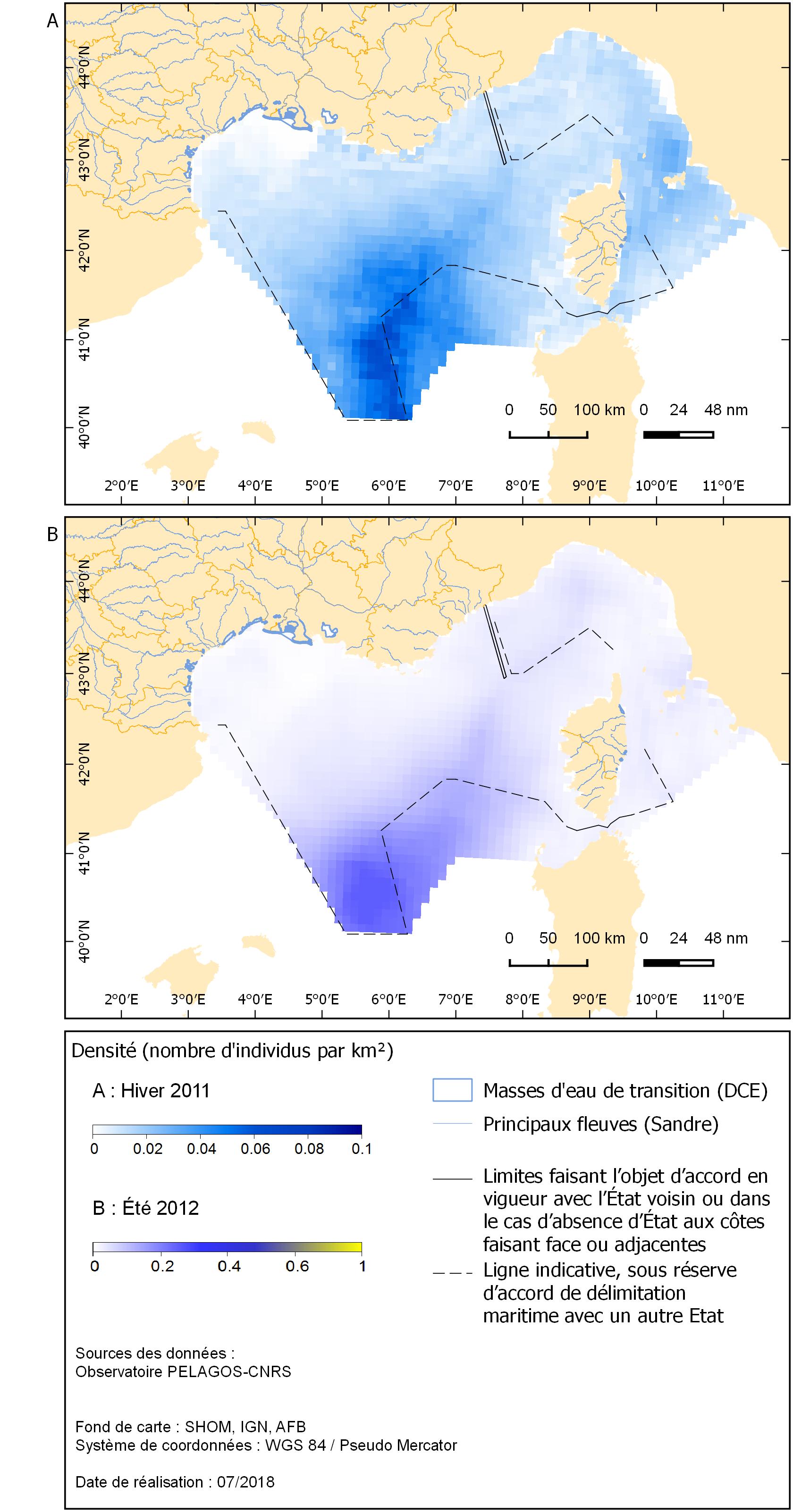
Les anomalies mensuelles de température de surface (°C) présentées correspondent à la différence entre la moyenne mensuelle et la moyenne des températures relevées pour le même mois de 2003 à 2017. Elles ont été calculées à partir du produit satellitaire MUR SST (Multi-scale Ultra-high Resolution Sea Surface Temperature) mesurant la température de surface des eaux à l'échelle du globe à une résolution égale à 0,01° (environ 1 km) et mises à disposition par la NASA (mur.jpl.nasa.gov). Les données téléchargées sont au format journalier avant d'être moyennées mensuellement.
-
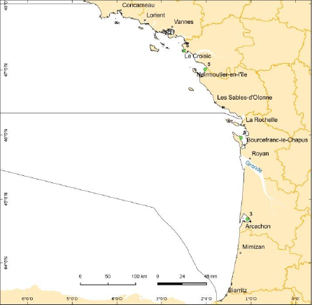
Ces résultats sont issus de l'extrapolation statistique de données récoltées lors de comptages effectués par des survols aériens en hélicoptère en 2013, en nombre de bateau en navigation par secteur du Référentiel spatial cumulé à l'année.
-
Le niveau de contaminants dans les tissus comestibles de produits de la mer capturés ou ramassés dans le milieu naturel constitue le critère de définition du descripteur 9 de la DCSMM (D9C1). L’indicateur retenu pour évaluer l’atteinte du bon état écologique pour ce critère (9.1.1) correspond aux niveaux réels des contaminants chimiques qui ont été détectés et le nombre de ces contaminants pour lesquels les teneurs maximales réglementaires ont été dépassées, pour la période comprise dans le cycle DCSMM (2010-2015). Le bon état écologique est atteint pour un contaminant si sa concentration dans la matrice utilisée (espèces et tissus) respecte la limite maximale réglementaire. Les unités géographiques d’évaluation sont les zones de capture ou de production définies conformément à l’article 38 du règlement n°1379/2013 du Parlement et Conseil européen. Les données sont présentées sous la forme d'un fichier de type shapefile. L’évaluation des contaminants a été effectuée sur des mollusques bivalves, en pg par kg de poids frais pour les dioxines, furanes et PCB-DL. Pour l'évaluation 2018, le bon état écologique pour les dioxines, furanes et PCB-DL est considéré comme atteint pour la sous-région marine Méditerranée Occidentale, et non atteint pour les sous-régions marines Manche-Mer du Nord, Golfe de Gascogne et Mer Celtique.
-
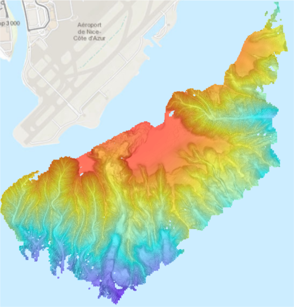
Bathymétrie du plateau au large de l'aéroport de Nice, en mer Ligure (campagne STEP 2015, en 2015), au pas de 2 mètres (WGS84 - Mercator 43,5°N). Acquisition des données par le sondeur multifaisceau ME70 en mode colonne d'eau, du N/O L'Europe. Référence verticale : niveau moyen des mers observé. Traitement : Gaillot Arnaud (2015). STEP5 - traitement SMF ME70. DIT.REM/GM/CTDI 20150505-AG01-STEP5_traitementME70.https://w3.ifremer.fr/archimer/doc/00276/38734/37250.pdf Description de la campagne : THOMAS Yannick, APPRIOUAL Ronan (2015) STEP 2015 cruise, RV L'Europe, https://doi.org/10.17600/15006100
-
La répartition constitue l’un des critères de définition du bon état écologique pour la composante "tortues marines" du descripteur 1 relatif à la biodiversité dans le cadre de la DCSMM (D1C4). Le bon état écologique des tortues marines est atteint lorsque la diversité biologique de ce groupe est conservée, la qualité des habitats, leur nombre ainsi que la distribution et l’abondance des espèces sont adaptées aux conditions physiographiques, géographiques et climatiques existantes. Pour cela, l’aire de répartition des espèces doit être conforme aux conditions physiographiques, géographiques et climatiques dominantes. Les cartes de répartition spatiale des tortues marines ont été obtenues à partir des données des campagnes aériennes SAMM. Les unités géographiques d’évaluation sont les sous-régions marines de la DCSMM. Le groupe d’espèces utilisé pour l’évaluation est le groupe de chélonidés. Le type et le volume de données actuellement disponibles ainsi que l’état de développement des indicateurs n'ont pas pu permettre d’évaluer quantitativement les critères du BEE pour les tortues marines. Les données sont présentées sous forme de fichiers géoréférencés de format TIF.
-
Le risque que l’étendue spatiale d’un habitat benthique soit modifié par une condition hydrographique constitue l’un des critères de définition de l’impact d’une modification permanente des conditions hydrographiques sur les écosystèmes marins dans le cadre de la DCSMM (D7C2). Le bon état écologique de ce descripteur est atteint lorsqu'une modification permanente des conditions hydrographiques ne nuit pas aux écosystèmes marins. L’évaluation du critère s’appuie sur 22 grands types d’habitats benthiques. Elle a été réalisée sur 15 unités marines de rapportage issues du découpage des 4 sous-régions marines Manche-Mer du Nord, Mers Celtiques, Golfe de Gascogne et Méditerranée Occidentale, suivant le zonage DCE et la profondeur bathymétrique à la limite des 200m. L’unité de mesure est l’étendue de chaque type d’habitat subissant des effets néfastes, en kilomètres carrés ou en proportion de l’étendue naturelle totale de l’habitat dans la zone d’évaluation. Les données sont présentées sous la forme de fichiers de type tif. Conformément à l'avis donné dans la guidance 14, aucun jugement sur le statut "Bon état écologique" n'est requis.