 Mon GéoSource
ESRI Shapefile
Type of resources
Available actions
Topics
INSPIRE themes
Keywords
Contact for the resource
Provided by
Years
Formats
Representation types
Update frequencies
status
Service types
Scale
Resolution
-
Abstract
-
Cold-water coral habitat mapping in submarine canyons of the bay of Biscay was realized by the deep sea laboratory of Ifremer. Data came from the BOBGEO2 cruise in the framework of the CoralFish project and as part of an agreement between Ifremer and the Agence des Aires Marines Protégées. The method was based on image analyses. Images were acquired using the towed camera « SCAMPI » during the BOBGEO2 cruise (from 18/07/2010 to 25/07/2010, chief scientist: Jean-François BOURILLET, Ifremer Brest). Observed habitats were defined according to the CoralFish typology (J.S. Davies, B. Guillaumont, F. Tempera, A. Vertino, L. Beuck, S.H. Ólafsdóttir, C.J. Smith, J.H. Fosså, I.M.J. van den Beld, A. Savini, A. Rengstorf, C. Bayle, J.-F. Bourillet, S. Arnaud-Haond, A. Grehan, 2017. A new classification scheme of European cold-water coral habitats: Implications for ecosystem-based management of the deep sea, In Deep Sea Research Part II: Topical Studies in Oceanography, Volume 145, 2017, Pages 102-109, ISSN 0967-0645, https://doi.org/10.1016/j.dsr2.2017.04.014).
-
Cold-water coral habitat mapping in submarine canyons of the bay of Biscay was realized by the deep sea laboratory of Ifremer. Data came from the EVHOE 2012 cruise in the framework of the CoralFish project and as part of an agreement between Ifremer and the Agence des Aires Marines Protégées. The method was based on image analyses. Images were acquired using the towed camera « SCAMPI » during the EVHOE 2012 cruise (from 18/10/2012 to 02/12/2012, chief scientists: Jean-Pierre LEAUTE and Michèle SALAUN). Observed habitats were defined according to the CoralFish typology (J.S. Davies, B. Guillaumont, F. Tempera, A. Vertino, L. Beuck, S.H. Ólafsdóttir, C.J. Smith, J.H. Fosså, I.M.J. van den Beld, A. Savini, A. Rengstorf, C. Bayle, J.-F. Bourillet, S. Arnaud-Haond, A. Grehan, 2017. A new classification scheme of European cold-water coral habitats: Implications for ecosystem-based management of the deep sea, In Deep Sea Research Part II: Topical Studies in Oceanography, Volume 145, 2017, Pages 102-109, ISSN 0967-0645, https://doi.org/10.1016/j.dsr2.2017.04.014).
-
Cold-water coral habitat mapping in submarine canyons of the bay of Biscay was realized by the deep sea laboratory of Ifremer. Data came from the EVHOE 2009 cruise in the framework of the CoralFish project and as part of an agreement between Ifremer and the Agence des Aires Marines Protégées. The method was based on image analyses. Images were acquired using the towed camera « SCAMPI » during the EVHOE 2009 cruise (from 18/10/2009 to 01/12/2009, chief scientists: Jean-Pierre LEAUTE and Michèle SALAUN). Observed habitats were defined according to the CoralFish typology (J.S. Davies, B. Guillaumont, F. Tempera, A. Vertino, L. Beuck, S.H. Ólafsdóttir, C.J. Smith, J.H. Fosså, I.M.J. van den Beld, A. Savini, A. Rengstorf, C. Bayle, J.-F. Bourillet, S. Arnaud-Haond, A. Grehan, 2017. A new classification scheme of European cold-water coral habitats: Implications for ecosystem-based management of the deep sea, In Deep Sea Research Part II: Topical Studies in Oceanography, Volume 145, 2017, Pages 102-109, ISSN 0967-0645, https://doi.org/10.1016/j.dsr2.2017.04.014).
-
Chemins conçus pour préserver et valoriser le patrimoine du Douaisis, protéger l'environnement et développer les loisirs. 200 km de chemins de randonnée sont proposés au public.
-

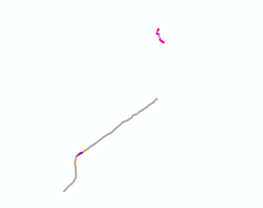
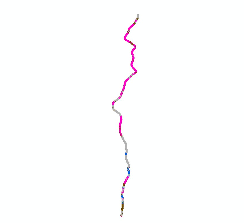
Habitat typology obtained from the statistical analysis of underwater video data collected from the STAVIRO autonomous unbaited video technique (AMBIO project)
-
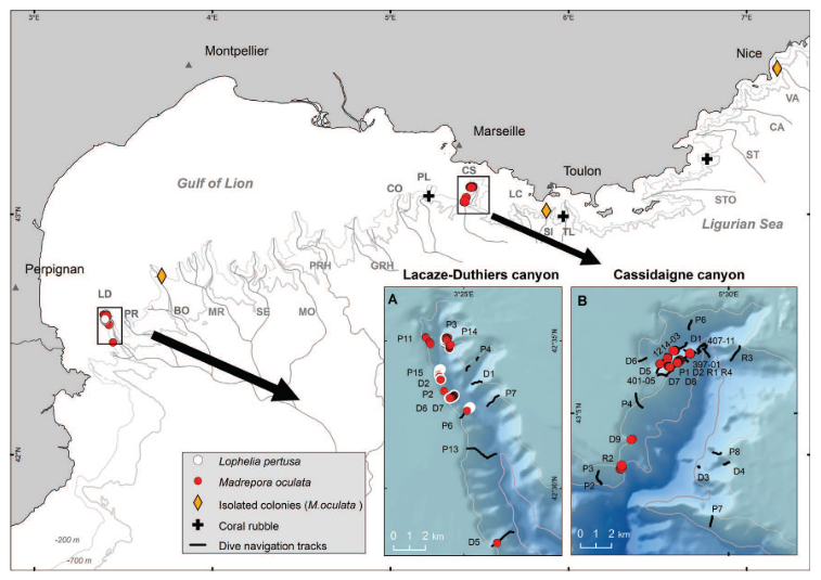
In the Mediterranean deep-sea two scleractinian species, Lophelia pertusa (= Desmophyllum pertusum) and Madrepora oculata, make up the dominant structure-forming corals. The Lacaze-Duthiers canyon is the only French Mediterranean canyon where the two species L. pertusa and M. oculata have been observed living together in large quantities, the situation generally described for the biocoenosis of cold-water corals (CWC). In this canyon large colonies (more than 40 cm) of both species of scleractinians were observed at depths ranging from 246 m to 541 m at the head of the canyon and its western flank. The second canyon is the Cassidaigne canyon, where M. oculata seems to be the only structure-forming scleractinian there. The largest concentration of M. oculata colonies was observed on the west flank of the canyon along a crest at depths ranging from 200 to 210 m. Mature M. oculata colonies attained heights up to 40 cm. M. oculata were observed in three other canyons: Bourcart, Sicié and Var. In the Bourcart canyon, M. oculata was observed on a shelf of hard substratum at 331 m depth. Several single branches protruded from a slab. In the Sicié canyon a 15-cm colony of M. oculata was observed at 255 m depth, while in the Var canyon, three young branches 2 cm long were seen growing at 350 m depth on a wall of hard rock. Data linked to the publication Fabri et al, 2014. https://doi.org/10.1016/j.dsr2.2013.06.016.
-
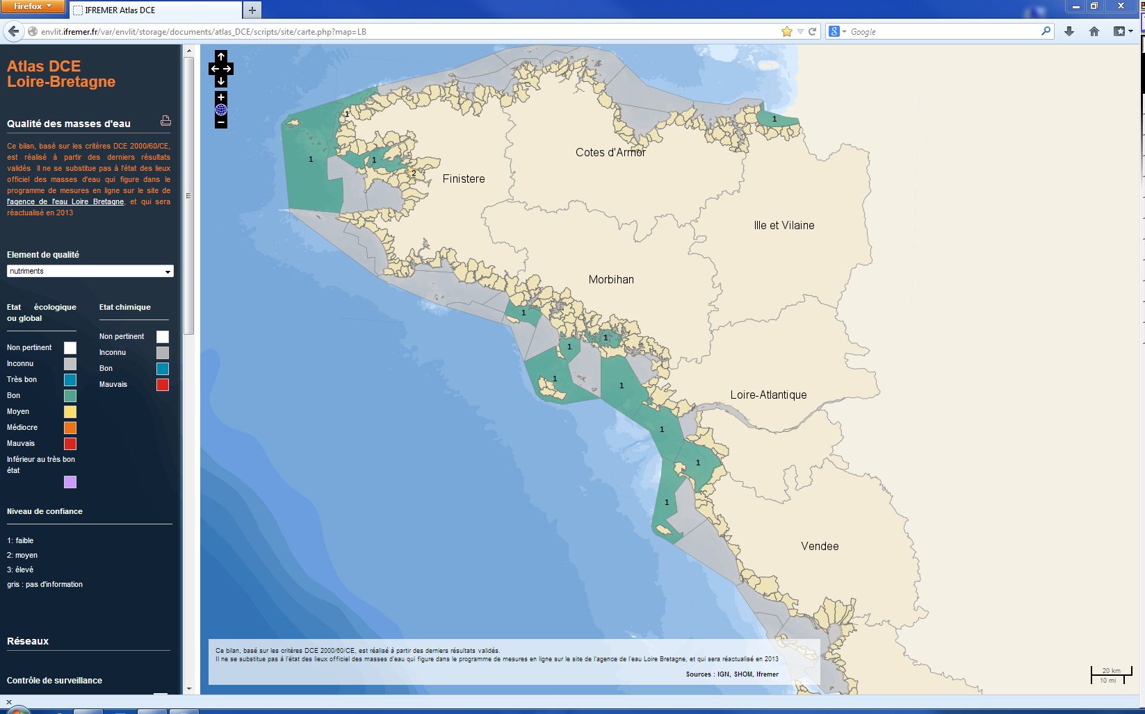
L’analyse porte sur le suivi des concentrations en nutriments des masses d'eaux côtières et de transition de la Manche ouest et du golfe de Gascogne. Le terme « nutriments » désigne l’ensemble des composés nécessaires à la nutrition du phytoplancton, dont les principaux sont le nitrate, le nitrite, l’ammonium, le phosphate et le silicate. Les nutriments ne sont pas directement toxiques pour le milieu marin, mais des flux excessifs déversés en zone côtière peuvent être considérés comme une pression à l’origine de nuisances indirectes pouvant conduire au phénomène d’eutrophisation. L’indicateur DCE nutriment est défini comme la combinaison des indices : ammonium, nitrate et nitrite. La métrique de l’indice est la concentration normalisée à 33 de salinité de l’ensemble des mesures effectuées, relativisée par rapport à un symptôme primaire d’eutrophisation : la chlorophylle-a. Les dosages de nutriments sont faits sur des échantillons prélevés mensuellement 4 à 12 fois par an. L’évaluation la plus récente de l’état de cet élément est présentée dans l’atlas DCE Loire-Bretagne. Les états antérieurs sont accessibles dans des archives annuelles.
-
bati_residentiel_1978 a été numérisé par photo-interprétation, à partir de photographies aériennes de 1978 de l'IGN (téléchargées sur Géoportail et géoréférencées par le LIENSs). Cette donnée a été créée pour les 4 communes d'étude de la Réunion : Saint-Denis, le Port, Saint-Paul et Saint-Pierre. Cette donnée (créée aussi pour 1950) ne concerne que la frange côtière de ces communes (bande littorale d'environ 100 m de largeur).
-
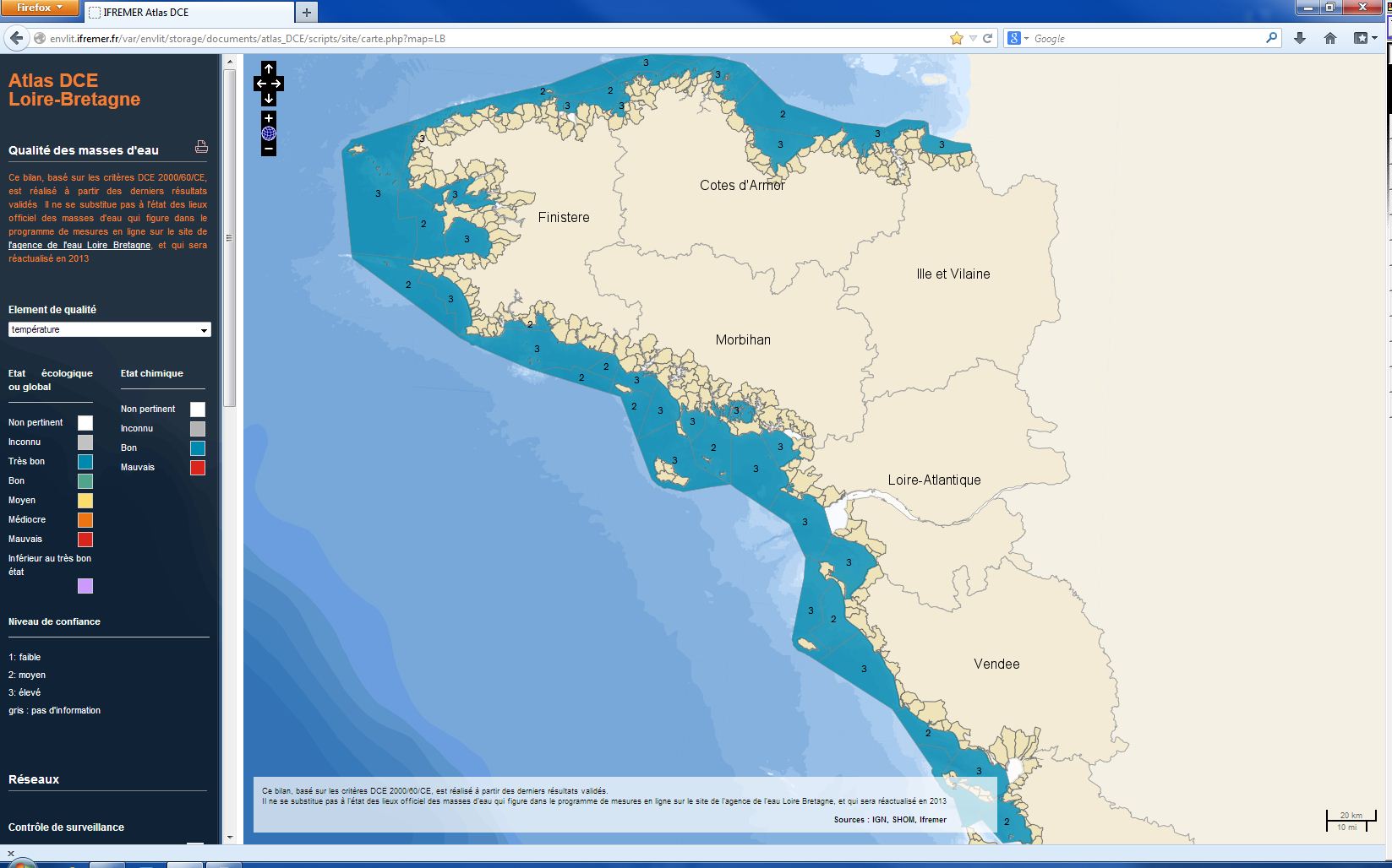
La température figure parmi les éléments de qualité pour la classification de l'état écologique des masses d’eaux littorales, c’est à dire les masses d’eaux côtières et les masses d’eaux de transition de la Manche ouest et du golfe de Gascogne. Les mesures de température sont effectuées sur site en sub-surface une fois par mois de janvier à décembre. L’indicateur température est défini comme le pourcentage de mesures hors d’une enveloppe considérée comme assurant le bon fonctionnement écologique de l’écosystème. Il permet un classement en deux états : bon ou mauvais. L’évaluation la plus récente de l’état de cet élément est présentée dans l’atlas DCE Loire-Bretagne. Les états antérieurs sont accessibles dans des archives annuelles.