 Mon GéoSource
notPlanned
Type of resources
Available actions
Topics
INSPIRE themes
Keywords
Contact for the resource
Provided by
Years
Formats
Representation types
Update frequencies
status
Scale
Resolution
-

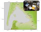
La rivière Ponteil draine le centre d'enfouissement des déchets d'Audenge. En aval de la décharge, la nappe phréatique chargée en ammonium et en chlorure alimente la rivière. Ceci se traduit par un flux de 10tonnes d'azote par an dans le Bassin d'Arcachon.
-
Depuis septembre 2007, un programme de recherche est en cours sur le cycle du carbone dans le bassin d’Arcachon. Une des différentes actions menées dans ce projet consiste à comprendre et quantifier les flux de carbone organique et inorganique transportés par les rivières alimentant la lagune. Ce point a fait l’objet d’un échantillonnage bi-mensuel depuis entre février 2008 et février 2009. L’objectif est aussi de comparer le flux de carbone biogénique exporté par la nappe phréatique plioquaternaire dans le bassin versant Leyre-Arcachon avec la production primaire forestière du bassin versant et aquatique du Bassin d’Arcachon lui-même.
-
Évolution temporelle des communautés benthiques et paramètres sédimentaires associés au récif naturel d’huîtres, des tables ostréicoles et de témoin sans huîtres.
-
Échantillonnage de l'eau de surface toutes les heures dans le Chenal de Teychan afin d'identifier les variations des paramètres bioogéochimique au cours d'un cycle nyctéméral (jour/nuit) et deux cycles de marée. L'échantillonnage est saisonnier. L'effet de la marée est plus important que l'effet jour/nuit sur les variations des paramètres mesurés.
-

Des prélèvements effectués tous les 15 jours à un mois dans les 15 cours d'eau qui se jettent dans le bassin d'Arcachon ont permis de faire le lien entre les flux d'azote et de phosphore de chaque bassin versant et l'occupation du sol. Les paramètres mesurés sont les nitrates, l'ammonium et l'azote organique dissous puis le phosphore organique et inorganique dissous. L'eau de pluie a aussi été analysée au cours de l'année 2008. Nous montrons que les flux en 2007-2008 ont légèrement augmenté durant la dernière décennie.
-
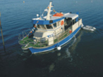
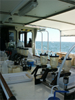
Station hydrologique de 24h depuis le navire Planula IV.Profils verticaux de salinité, température, courant et turbidité.
-

Cartes de la macrofaune benthique invertébrée réalisées à partir de 182 stations échantillonnées dans le Bassin d'Arcachon en 2001-2002.
-
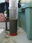
Les signatures élémentaires, isotopiques et biochimiques du sédiment des 6 stations benthiques de suivi sont analysées selon la découpe suivante: 0-0,5 / 0,5-1 / 1-2 / 2-3 / 3-5 / 5-7 / 7-10 cm
-
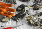
Évolution saisonnière de la physiologie des huîtres et intégration alimentaire. Comparaison des huîtres d’origine cultivées ou sauvages.
-
Caractérisation temporelle des paramètres environnementaux et des ressources alimentaires disponibles pour les huitres.