 Mon GéoSource
irregular
Type of resources
Available actions
Topics
INSPIRE themes
Keywords
Contact for the resource
Provided by
Years
Formats
Representation types
Update frequencies
status
Scale
Resolution
-
Comparaison des communes du LR classées en zone blanche avec les communes priorisées pour déploiement en 4G - 2012
-
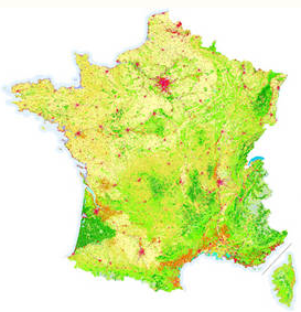
La base de données géographiques CORINE Land Cover est produite dans le cadre du programme européen CORINE, de coordination de l'information sur l'environnement. La continuité de ce programme et la diffusion des données sont pilotées par l'Agence européenne pour l'environnement.En France, l'Ifen est chargé d'en assurer la production, la maintenance et la diffusion. La base de données CORINE Land Cover 2000, dite CLC 2000, a été réalisée à partir d'images satellitaires de l'année 2000. C'est un véritable référentiel d'occupation du sol, mieux "calé" sur la BD cartographique de l'IGN, et proche par la date des recensements de la population (1999) et de l'agriculture (2000). Une première version de la base, dite CLC 1990, a été réalisée à partir d'images acquises entre 1987 et 1994. Elle a été corrigée pour de meilleures comparaisons avec CLC 2000.
-
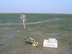
Mesures de la réflectance des surfaces sédimentaires et des herbiers afin d'interpréter les images satellites (classification des sédiments et de la végétation). Mesures réalisés pour des stages d'enseignement (diplômes d'études approfondies) et pour des recherches.
-

La relation hôte-parasite a été étudiée sous l'angle isotopique pour 4 systèmes: -Cerastoderma edule-Labratrema minimus -Cerastoderma edule-Monorchis parvus -Nassarius reticulatus-Lepocreadiidae -Nassarius reticulatus-Zoogonidae Il s'avère que la présence d'un parasite n'engendre pas ou peu de modifications de la signature isotopique des hôtes. Le fractionnement isotopique entre hôte et parasite est très éloigné de celui classiquement reporté pour le système proies-prédateurs.
-

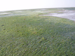
Photographies prises pour détermination des végétaux et des faciès sédimentaires du schorre et de la slikke.
-
Il s'agit d'un suivi des communautés zooplanctoniques du Bassin d'Arcachon en terme de diversité taxonomique et d'abondance. Le suivi est réalisé au sein des 2 masses d'eau caractéristiques du Bassin: les eaux néritiques externes et internes.
-
Base de données sur la macrofaune benthique invertébrée de quatre stations échantillonnées dans le Bassin d'Arcachon dans le cadre de la Directive Cadre sur l'Eau (DCE).
-
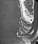
Photographies acquises dans un premier temps pour l'enseignement en géologie et géomorphologie. Elles concernent le Bassin d'Arcachon et les départements de la Gironde, des Landes et de la Dordogne. Dans un second temps, elles ont été acquises pour l'étude de la géomorphologie côtière.
-

Nos travaux ont pour objectif d’étudier la biogéochimie non stationnaire des sédiments intertidaux du Bassin d'Arcachon. Quatre stations caractéristiques des trois principaux types de sédiments intertidaux du bassin et favorables aux conditions transitoires sont échantillonnées depuis quelques années: 1) les sédiments sableux perméables dans le haut de plage (station 1/S); 2) les vases couvertes par Zostera noltii (station 3/VH), et 3) les vases nues (stations 2/VN et 4N marquées par des conditions redox différentes). Les questions fondamentales que nous souhaitons aborder dans ce travail concernent : i) l’influence des alternances émersion/immersion et jour/nuit sur les réactions biogéochimiques benthiques, et leurs influence sur les flux des composés biogéniques et de métaux traces ; ii) la dynamique biogéochimique et les processus spécifiques se déroulant dans les sédiments sableux perméables de la zone intertidal ; iii) la variabilité saisonnière de ces processus et le métabolisme net de ces environnements. Notre expertise repose sur l’utilisation d’outils in situ (voltammétrie, DET, profileur benthique) et ex situ (découpage et incubation de carottes).
-
54 poches contenant environ 17g de feuilles ou 5g de rhizomes de Zostera noltii ont été placées sur et sous du sédiment intertidal au site de Comprian. L'évolution temporelle (0j, 15j, 1 mois, 3 mois, 6 mois, 9 mois, 1 an) des signatures élémentaires, isotopiques et lipidiques de ces matériaux est étudiée.