 Mon GéoSource
biota
Type of resources
Available actions
Topics
INSPIRE themes
Keywords
Contact for the resource
Provided by
Years
Formats
Representation types
Update frequencies
status
Scale
Resolution
-
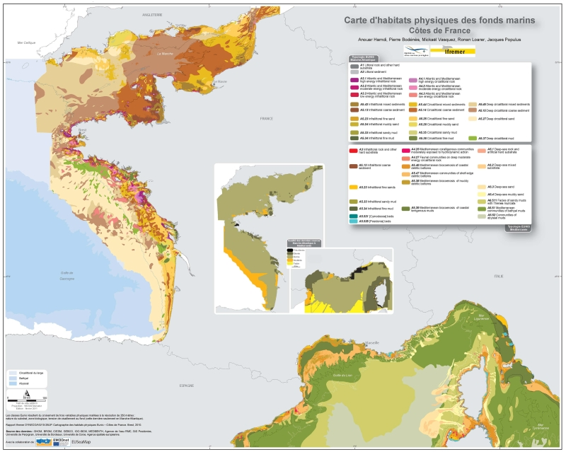
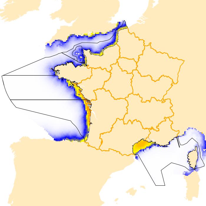
Eunis-classified physical habitats physiques resulting from the combination of three physical variables meshed at a resolution of 250 metres: nature of the substrates, biological area, shearing tension on the sea floor. Coasts of mainland France. Ifremer report "Hamdi Anouar, Vasquez Mickael, Populus Jacques (2010). Cartographie des habitats physiques Eunis - Côtes de France. Ifremer/AAMP agreement n° 09/12177764/FY. http://archimer.ifremer.fr/ doc/00026/13751/ "
-
Location distribution per grid cell of 8 harbor seals (Phoca vitulina), followed by Fastloc GPS / GSM tags from the bay of Mont Saint-Michel from 2006 to 2008
-
Modelised abundances of several species in coastal nurseries or prediction uncertainty.
-
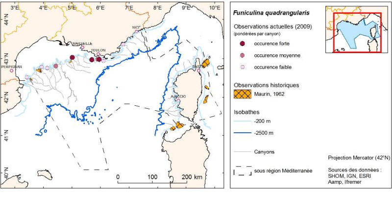
Layer of points representing the abundance weighted per canyon of observed organisms during submersible dives in the Mediterranean continental canyons.
-

The repository of location in the Fisheries Information System is divided into 3 categories: places on land, areas at sea and regulatory areas at sea. Each of these is organised hierarchically. There are 93 levels of places in Harmonie: a metadata sheet exists for each of them with, when it exists, a geographical layer.
-
-

The collection of socio-economic data from professional fishermen makes it possible to calculate economic indicators by fleet segment and contributes in particular to evaluating the economic performance of each fleet and the impacts of the implementation of management measures. It also makes it possible to evaluate the weight of French fishing in Europe, the share of fishing in the national and regional economy as well as the attractiveness of the profession and the impact of cost variations such as the cost of fuel.
-
The observation of ecosystems by Ifremer's Fisheries Information System (SIH) is based on a network of sea cruises. It aims to assess the state of stocks of the various species fished in France and Europe. It also enables the characterisation of the marine ecosystem in which the populations evolve. 23 scientific cruises take place each year at sea, enabling data to be collected for more than 30 years for the oldest. Thanks to the use of standardised fishing gear, the data acquired each year on board scientific vessels or professional fishing vessels contribute to the calculation of the index of abundance, with thousands of fish taken during timed trawls. The fish are measured and their age is assessed by measuring their otoliths (small bones located in the inner ear of the fish).
-
Cold-water coral habitat mapping in submarine canyons of the bay of Biscay was realized by the deep sea laboratory of Ifremer. Data came from the BOBGEO1 cruise in the framework of the CoralFish project and as part of an agreement between Ifremer and the Agence des Aires Marines Protégées. The method was based on image analyses. Images were acquired using the towed camera « SCAMPI » during the BOBGEO1 cruise (from 14/10/2009 to 28/10/2009, chief scientist: Jean-François BOURILLET). Observed habitats were defined according to the CoralFish typology (J.S. Davies, B. Guillaumont, F. Tempera, A. Vertino, L. Beuck, S.H. Ólafsdóttir, C.J. Smith, J.H. Fosså, I.M.J. van den Beld, A. Savini, A. Rengstorf, C. Bayle, J.-F. Bourillet, S. Arnaud-Haond, A. Grehan, 2017. A new classification scheme of European cold-water coral habitats: Implications for ecosystem-based management of the deep sea, In Deep Sea Research Part II: Topical Studies in Oceanography, Volume 145, 2017, Pages 102-109, ISSN 0967-0645, https://doi.org/10.1016/j.dsr2.2017.04.014).
-
The "Fishing trips" data in the declarative flow correspond to the catch and fishing effort data declared by the professionals in the logbooks for vessels whose overall length is greater than or equal to 10 metres, and the fishing sheets for vessels whose overall length is less than 10 metres.