 Mon GéoSource
series
Type of resources
Available actions
Topics
INSPIRE themes
Keywords
Contact for the resource
Provided by
Years
Formats
Representation types
Update frequencies
status
Scale
Resolution
-
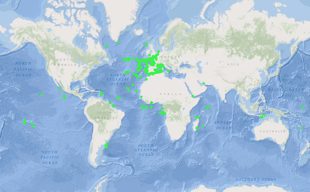
French national archive (SISMER) of time series data, particularly current meter and thermistor data.
-
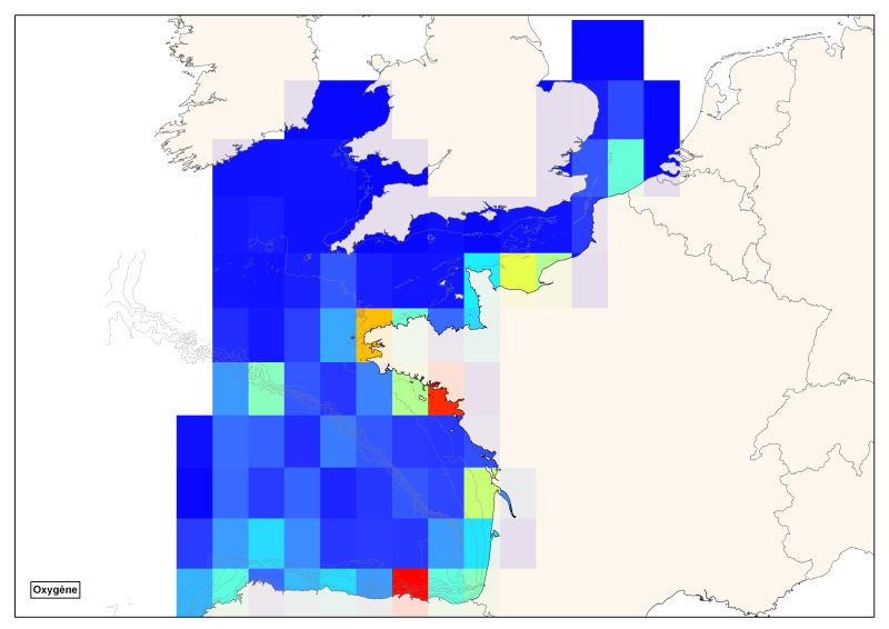
Spatial distribution of all oxygen data in degrees integrated vertically and horizontally for all sub-regions of the English Channel, the North Sea, the Celtic Seas and the Bay of Biscay.
-
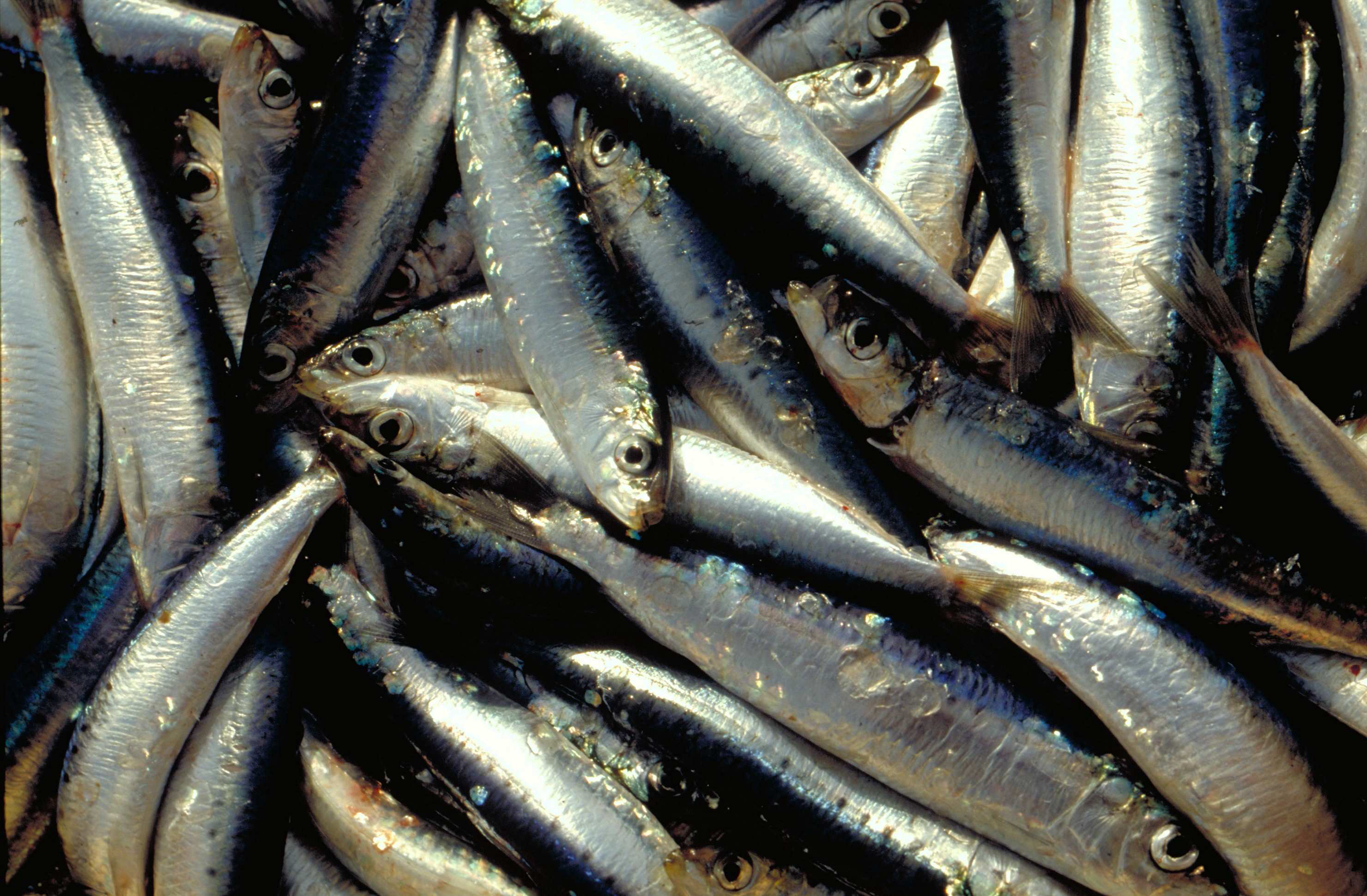
The annual PELMED (PELagiques MEDiterranée) fisheries resource assessment campaign is carried out by the Laboratoire Halieutique Méditerranée of the Ifremer station in Sète. The objectives of these cruises are : 1. Evaluate the biomass of small pelagic fish (anchovies, sardines) by direct method. For this, the campaign must alternate between acoustic prospecting and identification trawling. An acoustic signal is sent from a sounder fixed under the vessel and each time it encounters the bottom or schools of fish, it is reflected and retransmitted to the sounder. In this way, the shape and intensity of these echoes that materialize the schools of fish can be observed continuously. Species identification trawls are carried out in order to define the proportion of species present in the echoes detected. 2. Collecting as many biological parameters as possible on the target species of small pelagics (anchovies, sardines, sprats) to better understand the population dynamics of these species. For this purpose, morphometric measurements, as well as the determination of the sex and maturity stage of the fish are carried out. Finally, otoliths are taken in order to determine the age of the fish. These biological parameters are very important to complete the biomass assessment and have a better understanding of the processes underlying the variability of these populations. This allows for example to determine the age structure or size structure of the populations, to have an idea of their energy reserves, etc. 3. To better understand the pelagic ecosystem as a whole, from plankton to top predators. The primary goal of the PELMED cruise is to evaluate small pelagic stocks, but it also aims to accumulate as much data as possible on the different compartments of the pelagic ecosystem, from physical parameters (temperature, salinity) to top predators (marine mammals, birds), through the different lower trophic levels (phyto- and zooplankton, small pelagic fish). Thus, after each trawling, a hydrological station is carried out with the measurement of temperature and salinity along the water column via a CTD, water and phytoplankton samples with a Niskin bottle and zooplankton samples using a vertical line of WP2. Finally, throughout the campaign we carry out the observation and counting of birds and marine mammals. In addition to the understanding of the ecosystem, this should provide a number of indicators necessary for monitoring the marine environment under the MSFD (Marine Framework Directive).
-
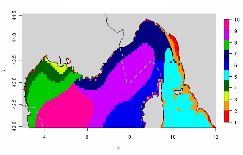
The distribution of hydrological landscapes is determined by a method of comparing multi-tables, to identify groups of individuals with similar variability of hydrological conditions during the year. The data used provides monthly tables showing the five selected physical parameters (SS, Phi, SST, MES et CHLA), calculated over the entire geographical area, a common resolution of 0.05°. This method identifies 10 hydrological landscapes showing a similar annual variability of hydrological conditions.
-
The observation of ecosystems by Ifremer's Fisheries Information System (SIH) is based on a network of sea cruises. It aims to assess the state of stocks of the various species fished in France and Europe. It also enables the characterisation of the marine ecosystem in which the populations evolve. 23 scientific cruises take place each year at sea, enabling data to be collected for more than 30 years for the oldest. Thanks to the use of standardised fishing gear, the data acquired each year on board scientific vessels or professional fishing vessels contribute to the calculation of the index of abundance, with thousands of fish taken during timed trawls. The fish are measured and their age is assessed by measuring their otoliths (small bones located in the inner ear of the fish).
-
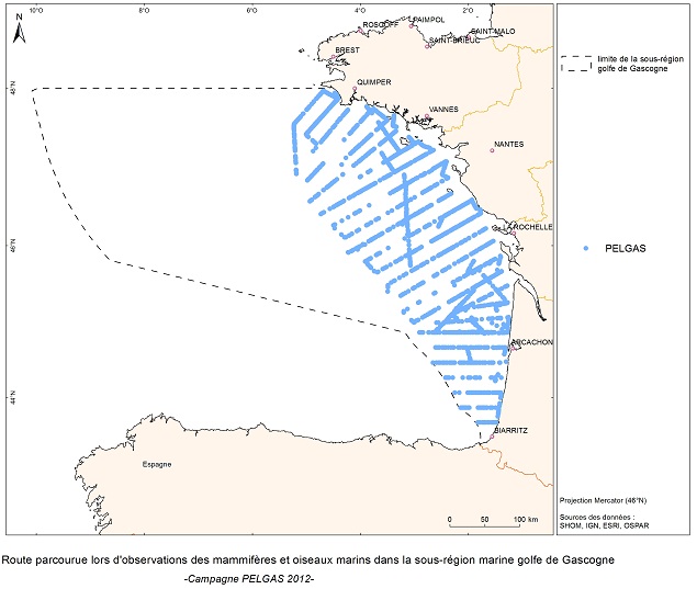
The objective of the PELGAS cruise is to monitor distribution and abundance of pelagic species fished in the Bay of Biscay, using two direct evaluation methods: acoustics and spawning estimates. The cruise was conducted in coordination with France, Spain and Portugal, in the framework of the European council regulations (EC No 1543/2000 of 29 June 2000 and No 1639/2001 of 25 July 2001).
-
The Bargip project : acquisition of scientific data and knowledge to produce advices on integrated management of European sea bass (Dicentrarchus labrax) in North-East Atlantic.
-
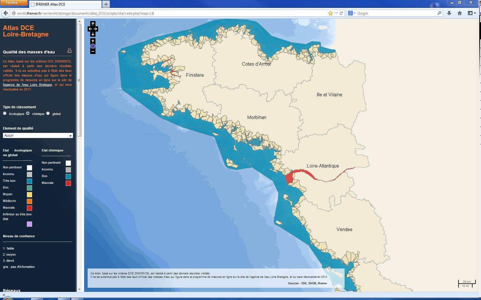
The chemical status of a coastal water body (coastal water or transition water) is determined by the most declassing of the defined states for heavy metals, pesticides, industrial pollutants and other pollutants taken into account by the WFD . The assessment is done once per management plan (once every six years). The most recent assessment of the state of the chemical state is presented in the DCE Loire-Bretagne atlas. Earlier reports are available in annual archives.
-
Since 2008, the Coastal Chemical Contamination Observation Network (ROCCH) has taken over from RNO (French National Observation Network for Quality in Marine Environments), which had existed since 1974. ROCCH aims to meet national, community and international obligations relating to monitoring chemicals in marine environments. It is therefore more of a control network than a heritage network as RNO once was. The backbone of ROCCH is to apply the European Water Framework Directive (WFD) and to meet the obligations set out in OSPAR Conventions and in Barcelona. As the WFD insisted on decentralization, ROCCH has gone from having just one project leader (the Ministry for the Environment) to having many decision-makers (water agencies, DIREN etc.). Chemical analyses are no longer conducted by Ifremer alone, but are attributed to other partners following calls for tender. ROCC also includes the monitoring of chemicals in shellfish production areas for the Food safety agency (DGAL) and the Ministry for Agriculture and Fisheries. Monitoring focuses on the three regulated metals: mercury, lead and cadmium in the given areas. Monitoring of these chemical contaminants is conducted in the three marine matrices: water, biota and sediment. Testing also includes imposex, the biological effect of tributyltin (TBT), as required by the OSPAR convention.
-
Visual Observations on the Dedicated Aerial Platform - 2. Sampling Programme- PACOMM/SAMM1 and SAMM2
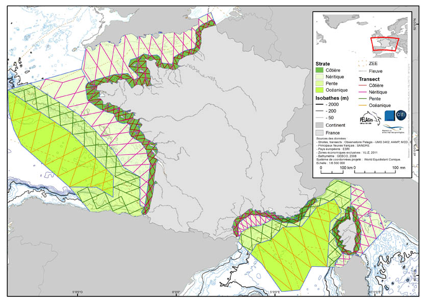
The associated data highlights the sampling programme for the data acquisition campaign of Observation on the Aerial Platform for the SAMM1and SAMM2 campaigns (Aerial Marine Megafauna Monitoring) conducted by the PELAGIS observatory (UMS 3462 ULR/CNRS). The sampling plan is composed of preestablished sampling strata and transects. These were drawn up according to the specific characteristic of the study area “Mainland France”, or FrM. Description of fields and values of allocation tables: : ( - field name, meaning: value, description of values) region char 5 Study area region_lbl char 50 labelled study area idCampagne (survey) char 15 Name of the campaign programme char 20 Programme name sector char 10 Sampling sector short ID strate char 5 Sampling strata short ID strate_lbl char 15 Labelled sampling strata areaKM double Strata surface area transect_name char 10 transect sampling length_km double Transect length start_x double Coordinates of the start of transect x in decimal degree start_y double Coordinates of the start of transect y in decimal degree end_x double Coordinates of the end of transect x in decimal degree end_y double Coordinates of the end of transect y in decimal degree