 Mon GéoSource
/Physical Environment/Bathymetry/Digital Terrain Model
Type of resources
Available actions
INSPIRE themes
Provided by
Representation types
Update frequencies
status
Scale
Resolution
-
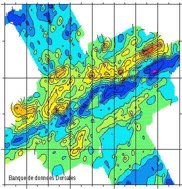
Données de bathymétrie sur la dorsale de Mohns (Atlantique Nord), en vue d'une étude des mécanismes de l’accrétion océanique a l'axe des dorsales.
-
Etude géophysique et géochimique de la dorsale Pacifique-Antarctique, entre S65/W175 et S60/W150. Le premier objectif est de contribuer à la compréhension et à la modélisation des mécanismes de fonctionnement de la dorsale océanique à l'échelle de la cellule élémentaire d'accrétion (< 100 km). Le second est l'étude de la zonation du manteau supérieur à différentes échelles, via l'étude de la signature géochimique des roches provenant de la vallée axiale. Cette campagne s'inscrit dans le cadre du programme Inter-Ridge et résulte d'une collaboration entre IFREMER/DRO/GM, l'INSU (CNRS,IPG, GRGS), l'Université de Washington, la Scripps (Université Californie) et l'Université de Chiba (Japon).
-
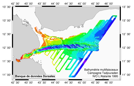
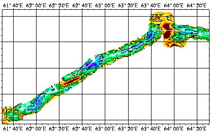
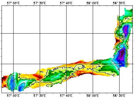
Levés EM12 et EM 950 + gravimétrie, magnétisme et sismique rapide pour étude du mécanisme de propagation de la dorsale océanique du golfe d'Aden vers l'ouest (golfe de Tadjoura et Ghoubbet).
-
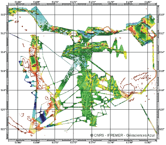
Bathymétrie du bassin Nord Fidjien produite à partir de plusieurs campagnes réalisées en 1985 et 1997
-
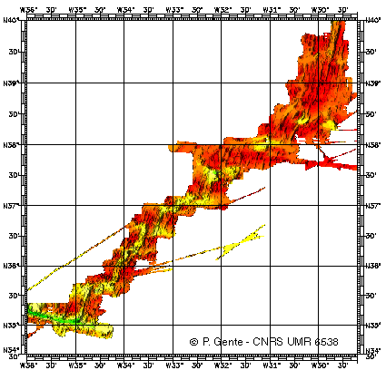
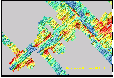
Identification d'une manière géophysique (magnétisme, gravimétrie et bathymétrie), les segments de la dorsale Atlantique entre 30 et 35N, actuels et passés (jusqu'à 10 millions d'années), en précisant leur géométrie et leurs frontières.
-
Reconnaissance geophysique, geologique, petrographique et geochimique systematique.Transit valorisé Le Cap-Singapour
-
Etude géophysique et géochimique de la dorsale Pacifique-Antarctique, entre S65/W175 et S60/W150. Le premier objectif est de contribuer à la compréhension et à la modélisation des mécanismes de fonctionnement de la dorsale océanique à l'échelle de la cellule élémentaire d'accrétion (< 100 km). Le second est l'étude de la zonation du manteau supérieur à différentes échelles, via l'étude de la signature géochimique des roches provenant de la vallée axiale. Cette campagne s'inscrit dans le cadre du programme Inter-Ridge et résulte d'une collaboration entre IFREMER/DRO/GM, l'INSU (CNRS,IPG, GRGS), l'Université de Washington, la Scripps (Université Californie) et l'Université de Chiba (Japon).
-
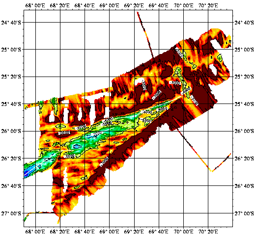
Reconnaissance geophysique, geologique, petrographique et geochimique systematique du point triple de Rodriguez ou convergent trois dorsales medio-oceanique. Exploration geophysique, geologique, petrographiqueet geochimique d'un segment de la zone axiale de chacune des trois dorsales. Reconnaissance, dans le bassin de Wharton, d'une dorsale fossile.
-
Reconnaissance geophysique, geologique, petrographique et geochimique systematique.Transit valorisé Le Cap-Singapour
-
Etude géophysique et géochimique de la dorsale Pacifique-Antarctique, entre S65/W175 et S60/W150. Le premier objectif est de contribuer à la compréhension et à la modélisation des mécanismes de fonctionnement de la dorsale océanique à l'échelle de la cellule élémentaire d'accrétion (< 100 km). Le second est l'étude de la zonation du manteau supérieur à différentes échelles, via l'étude de la signature géochimique des roches provenant de la vallée axiale. Cette campagne s'inscrit dans le cadre du programme Inter-Ridge et résulte d'une collaboration entre IFREMER/DRO/GM, l'INSU (CNRS,IPG, GRGS), l'Université de Washington, la Scripps (Université Californie) et l'Université de Chiba (Japon).