 Mon GéoSource
2019
Type of resources
Available actions
Topics
INSPIRE themes
Keywords
Contact for the resource
Provided by
Years
Formats
Representation types
Update frequencies
status
Service types
Scale
Resolution
-
Abstract
-
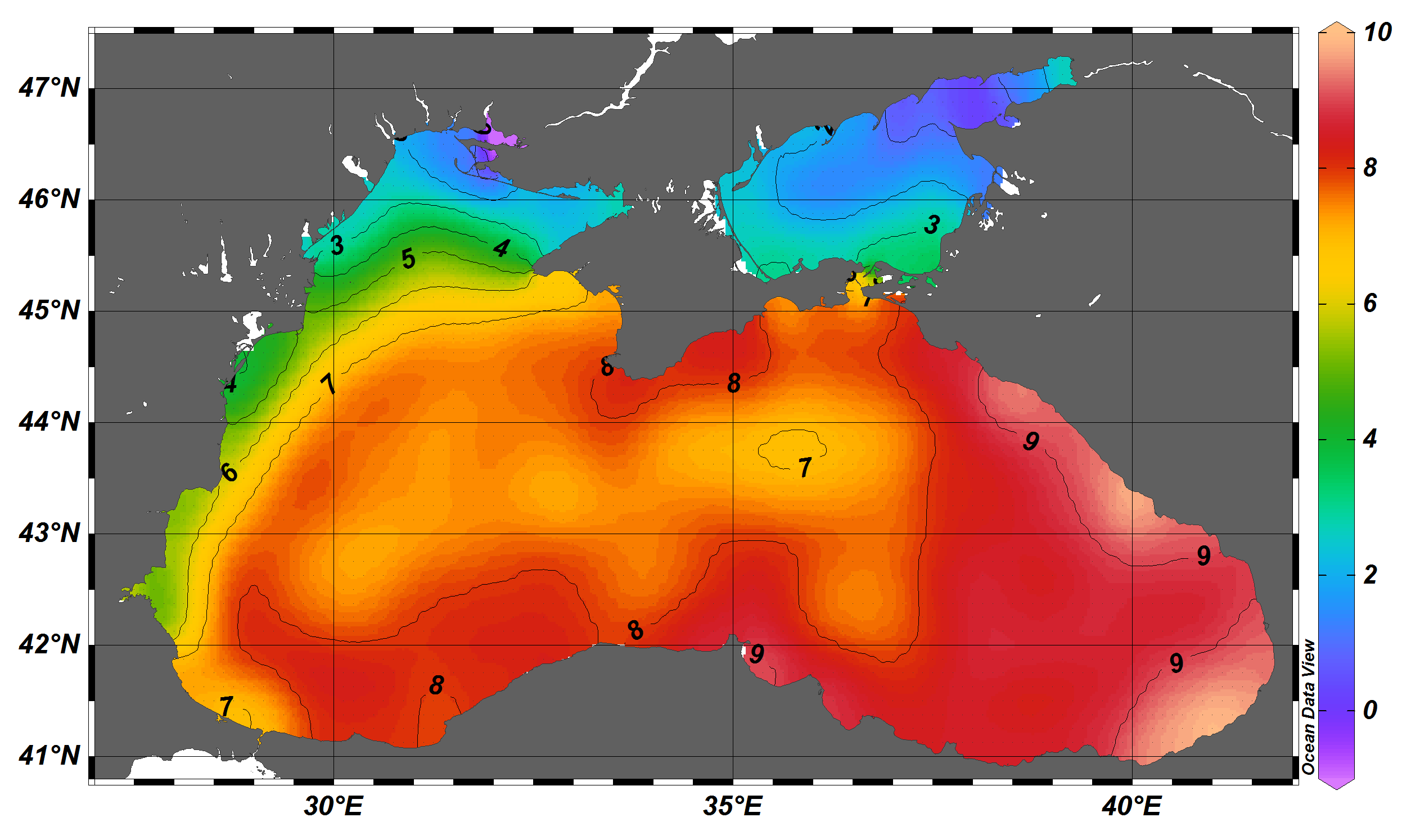
The SDC_BLS_CLIM_TS_V1 product contains Temperature and Salinity Climatologies for Black Sea including the seasonal and monthly fields for period 1955-2017 and seasonal fields for 6 decades starting from 1955 to 2014. The climatic fields were computed from the integrated Black Sea dataset that combines data extracted from the 3 major sources: 1) SeaDataNet infrastructure, 2) World Ocean Database 2018, and 3) Coriolis Ocean Dataset for Reanalysis. The computation was done with the DIVAnd (Data-Interpolating Variational Analysis in n dimensions), version 2.3.1.
-
Serveur wms public de l'Ifremer - projet REPAMO
-
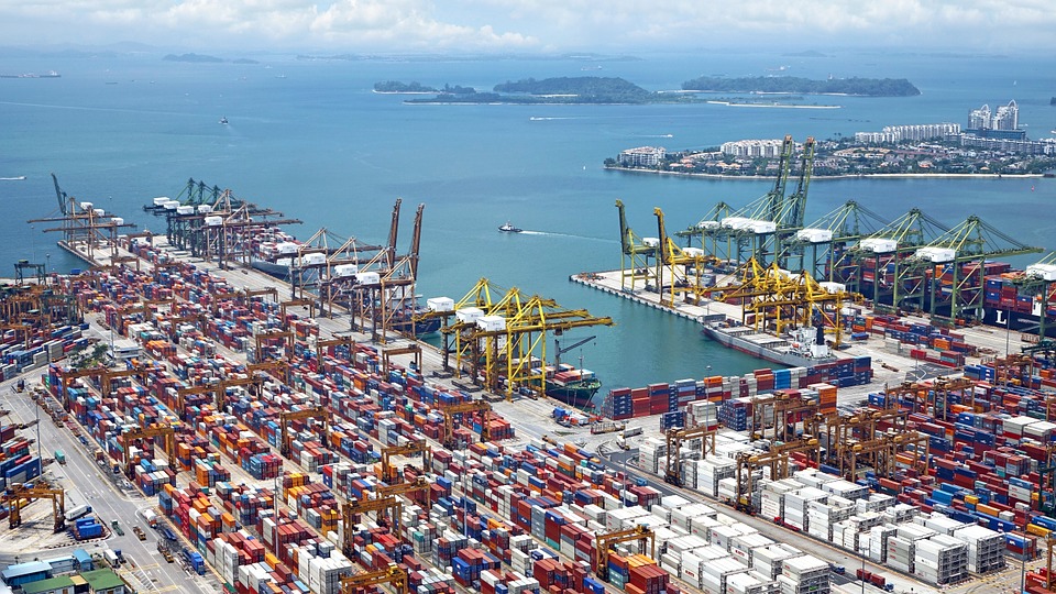
World list of seaports. In its 2021 version, the repository includes 13709 ports for 187 countries. The list of seaports has been drawn up on the basis of the information available in the European reference system of places used in the framework of the Common Fisheries Policy and, more particularly, by the Electronic Recording and Reporting System (ERS), the list of ports identified by the UNECE (2021-1). An assessment of the infrastructures present along the coastline made it possible to identify other ports that were not listed. Each geographical position has been verified with Google Earth in WGS84. Each port is associated with information relating to the country (ISO 3 coding), the UNECE or ERS 5-character coding, the name, the geographical position in WGS84 (latitude and longitude), the status of the port indicating whether it is referenced by Unece (UNECE), by the EU/ERS (ERS) or by both (UNECE/ERS) In case the port is not referenced by UNECE or ERS, the status is N/A. For French ports, the reference system integrates the ports of the French overseas departments and territories with the national codification. Inland ports have also been integrated in 2021.
-
Nombre de dossiers Aide au Transport aux Particuliers (ATP) acceptés en région Hauts-de-France (de mars 2016 à décembre 2020), par commune de résidence, par commune du lieu de travail et avec le nombre de mois aidés Plus d'informations : https://www.hautsdefrance.fr/aide-transport/
-
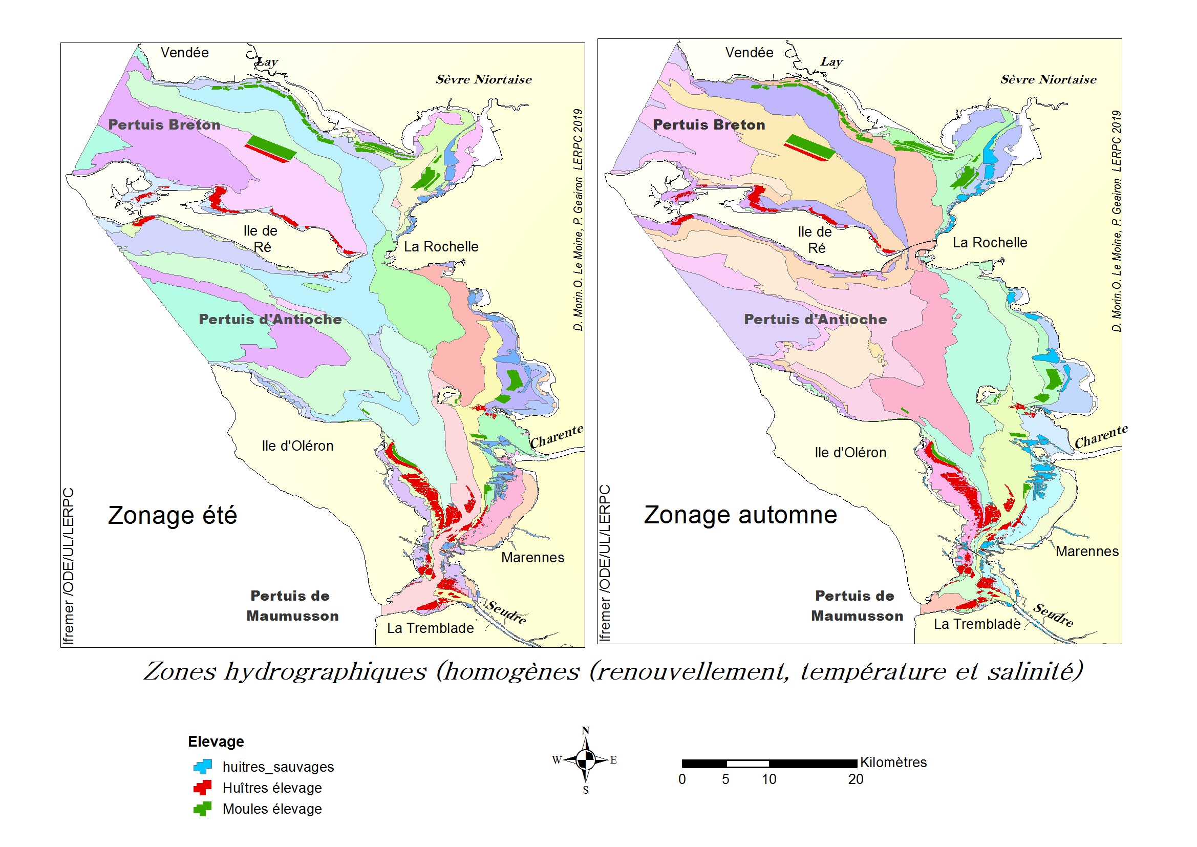
Carte représentant les zones hydrographiques homogènes par saison de 2012 à 2017
-

Carte représentant la température estivale moyennée sur plusieurs années (2012 à 2017), une des variables utilisée dans un processus géostatistique afin de définir un zonage hydrographique cohérent en terme de risque microbiologique.
-
Le schéma d'accessibilité identifie par tronçon si la voirie (trottoir, arrêt de bus, franchissement) est accessible aux personnes à mobilité réduite, conformément à la réglementation en vigueur. 3 niveaux d'accessibilité sont déterminés pour effectuer un parcours : tronçon accessible, accessible avec assistance ou inaccessible aux PMR. Localisation et spécifications des places de stationnement PMR
-
Le schéma d'accessibilité identifie par tronçon si la voirie (trottoir, arrêt de bus, franchissement) est accessible aux personnes à mobilité réduite, conformément à la réglementation en vigueur. 3 niveaux d'accessibilité sont déterminés pour effectuer un parcours : tronçon accessible, accessible avec assistance ou inaccessible aux PMR. Identification des éléments de voirie formant un obstacle à la circulation piétonne.
-
Géoréférencement des photographies aériennes du littoral aquitain réalisée en 2018 par Olivier Chaldebas (ULM Sud Bassin) pour l'Observatoire de la Côte Aquitaine.