 Mon GéoSource
continual
Type of resources
Available actions
Topics
INSPIRE themes
Keywords
Contact for the resource
Provided by
Years
Formats
Representation types
Update frequencies
status
Service types
Scale
Resolution
-
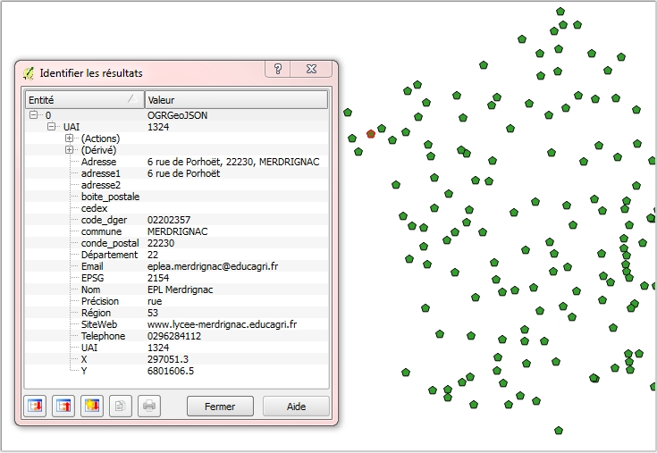
Géolocalisation des établissements publics locaux d’enseignement et de formation professionnelle agricoles : Position géographique des établissements en WGS84 (4326) sur l'ensemble du territoire (France métropolitaine et DOM COM). Attributs : Éléments de contact (nom,adresse, téléphone, mail..) et coordonnées géographiques officielles des établissements concernés. Mise à jour mensuelle. Information de précision des données : Dans la mesure du possible, la donnée est au bâtiment près ou à la rue; il existe cependant des cas où le centre de la commune est le point de référence (cf. champ "Précision").
-

Il s'agit d'enregistrements de courant et de hauteur d'eau effectués dans le chenal de Lanton.
-
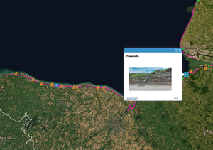
Le sentier du littoral doit permettre aux piétons d'accéder au rivage de la mer et de cheminer le plus possible le long du littoral. Il désigne la totalité du tracé ouvert le long de la mer. Il n'a pas de statut juridique unique car il est constitué de tronçons de nature juridique différente. Selon la nature des terrains bordant le domaine public maritime, le sentier passe sur du domaine public de l’État ou des collectivités territoriales, ou sur des propriétés privées. L'ensemble du cheminement constituant le sentier du littoral comprend le cheminement ouvert aux piétons, le linéaire de sentier à étudier ou accessible à court terme, le linéaire du littoral inaccessible. Cette couche répertorie les points d'intérêt situés à proximité immédiate du sentier du littoral (monuments, points de vue, belvédères, sites particuliers, etc....) sur une partie des départements littoraux métropolitains, les Antilles Françaises, la Guyane et Saint-Pierre et Miquelon. A terme, les données seront consultables sur l'ensemble du littoral métropolitain et de l'outre-mer. Cette ressource est en conformité avec le standard de données COVADIS sur le sentier du littoral (version 1.0 - document du 22 janvier 2014).
-
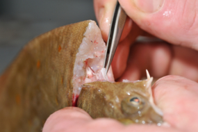
ObsBio, la collecte de paramètres biologiques individuels tels que la taille, le poids, le sexe, l'âge sont des données nécessaires pour connaître par élévation, la part des populations dans le recrutement des jeunes poissons, dans la mortalité naturelle et dans la mortalité par pêche
-

Le référentiel des espèces scientifiques du Système d’Informations Halieutiques recense les espèces observées lors des campagnes halieutiques ou dans le cadre des observations des programmes de collecte (ObsVentes, ObsMer, Campagnes,…).
-

Pour certaines espèces commerciales, des coefficients appelés équivalent poids vifs permettent de calculer le poids vif du poisson à partir du poids enregistré au débarquement, ou à partir du poids net des divers produits transformés préparés à bord ou dans des usines installées sur le littoral.
-

Le référentiel des espèces exploitées d’intérêt commercial du Système d’Informations Halieutiques reprend le référentiel ASFIS de la FAO enrichi d’espèces ayant un fort intérêt commercial en France (métropole et outre-mer).
-

Le Pays Compiégnois dispose depuis 2017 d'un Référentiel Voies et Adresses (RVA) sur les communes du Pays. Localisation de l’adresse postale sous la forme d’un point. Localisation des tronçons de voies sous la forme de lignes.
-
Géolocalisation des établissements d’enseignement agricole : Position géographique des établissements en WGS84 (4326) sur l'ensemble du territoire (France métropolitaine et DOM COM). Attributs : Éléments de contact (nom,adresse, téléphone, mail..) et coordonnées géographiques officielles des établissements concernés. Mise à jour mensuelle. Information de précision des données : Dans la mesure du possible, la donnée est au bâtiment près ou à la rue; il existe cependant des cas où le centre de la commune est le point de référence (cf. champ "Précision").