 Mon GéoSource
oceans
Type of resources
Available actions
Topics
INSPIRE themes
Keywords
Contact for the resource
Provided by
Years
Formats
Representation types
Update frequencies
status
Scale
Resolution
-
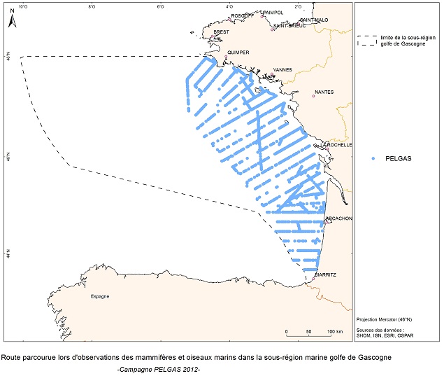
L'objectif de la campagne PELGAS est de surveiller la distribution et l'abondance des espèces pélagiques pêchées dans le golfe de Gascogne, en utilisant deux méthodes d'évaluation directe : l'acoustique et les estimations de frai. La croisière a été menée en coordination avec la France, l'Espagne et le Portugal, dans le cadre des règlements du Conseil européen (CE n° 1543/2000 du 29 juin 2000 et n° 1639/2001 du 25 juillet 2001).
-
L’analyse porte sur le suivi de l'état écologique des masses d'eaux côtières et de la frontière Belge à la Baie de Somme. L'état biologique d'une masse d'eau littorale au sens de la directive cadre européenne sur l'eau (DCE) est déterminé par l'état des macrophytes (végétation autre que phytoplancton), l'état du phytoplancton, l'état de la faune benthique (ou invertébrés benthiques) et l'état des poissons (dans le cas des masses d'eau de transition) de la masse d'eau. L'état est déterminé selon les règles décrites dans l'arrêté du 25 janvier 2010.
-

Carte représentant la température estivale moyennée sur plusieurs années (2012 à 2017), une des variables utilisée dans un processus géostatistique afin de définir un zonage hydrographique cohérent en terme de risque microbiologique.
-
La modélisation des courants consiste à recalculer, pour chaque pas de temps, les composantes vitesses et directions du courant en chacune des maille du modèle, pour chaque niveau de profondeur (30) sur la totalité de l'emprise (~7 millions de cellules recalculées à chaque pas de temps). Dans le cadre du projet Hydrorun, une année complète de simulation réaliste (> 50 000 pas de temps) a été générée. Parmi les paramètres de synthèse produits, ici sont présentés : - Percentile 90 de la vitesse journalière du courant barotrope (calculé sur l'année 2006) en mètres par seconde - Percentile 90 de la vitesse journalière du courant de surface (calculé sur l'année 2006) en mètres par seconde Format de diffusion : GeoTIFF (*.TIFF + *.TFW) et Netcdf (*.nc)
-

Un échantillonnage mensuel, de la colonne d'eau (en surface) de la Leyre au pont de Lamothe, est effectué afin de mesurer la variation de la qualité de la matière organique particulaire d'origine continentale.
-
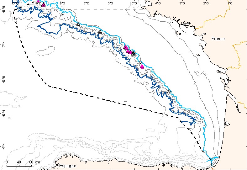
Couche de points représentant les observations d'habitats particuliers des mers celtiques et du Golfe de Gascogne depuis le début du XXème siècle.
-
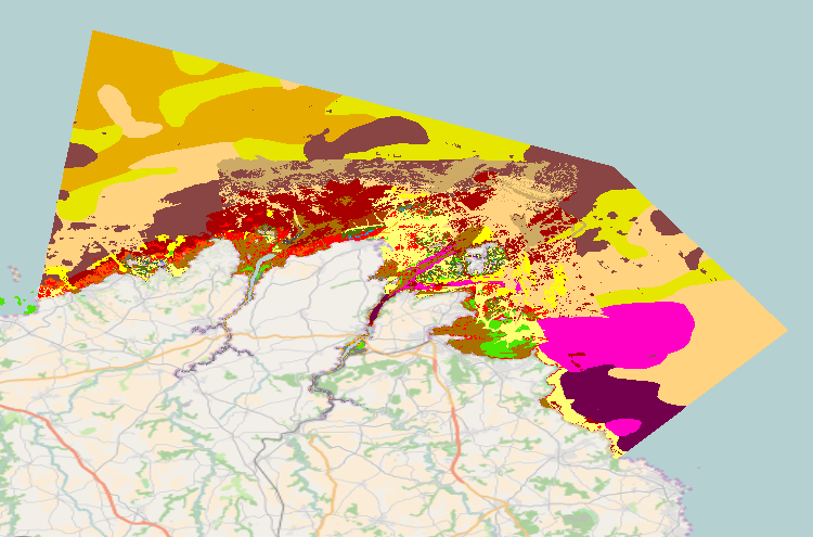
La carte de synthèse des inventaires d’habitats benthiques du site de Trégor-Goëlo a été élaborée en exploitant principalement des données des projets Rebent, Natura 2000 et CARTHAM. Les données sources sont issues à la fois de l'interprétation d'images acoustiques (sondeur multifaisceau, sonar à balayage latéral, RoxAnn) et aériennes (ortholitorales 2000, imagerie blom de 2008), de vidéos sous-marines, de prélèvements biosédimentaires et de validations terrain à pied et en bateau (observations, relevés GPS, photographies, etc.) réalisés entre 2008 et 2013. Les vides ont été comblés par interprétation lorsque des données bathymétriques et des images optiques étaient disponibles, ou par extrapolation. La classification des habitats a été élaborée selon les principaux référentiels à savoir : - La typologie des habitats génériques de la directive habitats , - Les habitats élémentaires des cahiers d’habitats, - La typologie Rebent - Le standard européen ENIS au niveau 4 dans la mesure du possible
-

Les anomalies mensuelles de température de surface (°C) présentées correspondent à la différence entre la moyenne mensuelle et la moyenne des températures relevées pour le même mois de 2003 à 2017. Elles ont été calculées à partir du produit satellitaire MUR SST (Multi-scale Ultra-high Resolution Sea Surface Temperature) mesurant la température de surface des eaux à l'échelle du globe à une résolution égale à 0,01° (environ 1 km) et mises à disposition par la NASA (mur.jpl.nasa.gov). Les données téléchargées sont au format journalier avant d'être moyennées mensuellement.
-
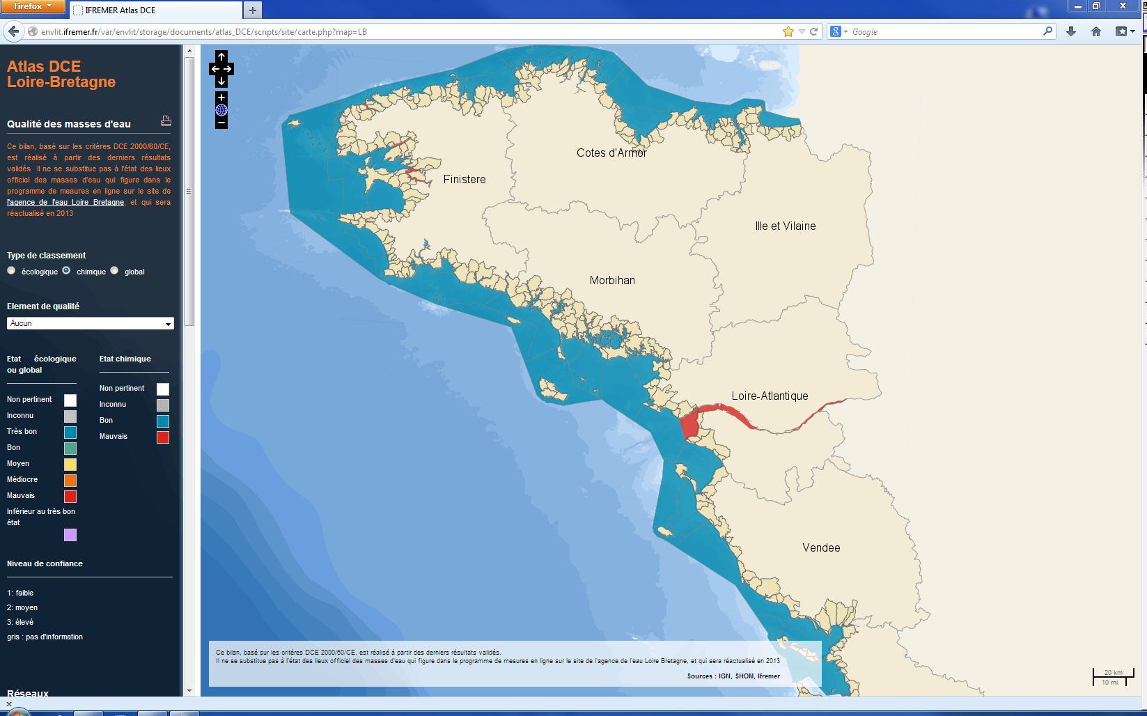
L’évaluation de l'état chimique de la masse d’eau repose sur deux Normes de Qualité Environnementale (NQE) établies pour chaque substance ou groupe de substances dans la directive 2008/105/CE. Ces normes représentent des seuils à ne pas dépasser afin de protéger l’environnement et la santé humaine : - La NQE-CMA : qui représente la Concentration Maximale Admissible (μg/L) ; - La NQE-MA : qui présente la Concentration Moyenne Annuelle à ne pas dépasser (μg/L). L’état chimique est défini par 2 classes de qualité : « bon état » ou « mauvais état ». Les pesticides - 8 substances de la liste des substances prioritaires et 10 substances de la liste des substances dangereuses prioritaires - sont recherchés dans l'eau (substances hydrophiles) ou dans les coquillages et le sédiment (substances hydrophobes). L’évaluation la plus récente de l'état chimique est présentée dans l’atlas DCE Loire-Bretagne. Les états antérieurs sont accessibles dans des archives annuelles.
-
Données traitées issues du satellite OLCI FR. Les paramètres observés sont la matière en suspension, la chlorophyl-a, la turbidité et le rayonnement photosynthétiquement actif (KPAR) sur la zone des Antilles Françaises (Guadeloupe). Il s'agit de données journalières, mensuelles (moyenne) et annuelles (moyenne et P90) sur la période 2016-2018 Les données ont été traitées à partir des données brutes, dans le cadre d'une convention Ifremer-AFB.