Topic
 

biota

1135 record(s)
 
Type of resources
Available actions
Topics
INSPIRE themes
Keywords
Contact for the resource
Provided by
Years
Formats
Representation types
Update frequencies
status
Scale
Resolution
From 1 - 10 / 1135
  • An inventory of mäerl ( unfixed red marine algae Corallinaceae with calcified arbuscular thalli) is taken in the Pertuis Charentais using the compilation of historical data and new observations over the period 2006-2012. The geographic extent of the inventory includes Pertuis Breton, Antioch and Maumusson, extends from the Lay estuary in the north to the Bay of Marennes-Oléron in the south and includes the edges of the islands of Ré, Oléron and Aix. Contributing to this inventory are, surveys DCE 2006 DCE, control monitoring DCE 2007 to 2012 under the aegis of Ifremer and Agences de l’Eau Loire-Bretagne and Adour-Garonne, surveys conducted for the Port Atlantique La Rochelle on the site of dredge spoil deposits in Lavardin from 2007 to 2012, surveys in 2007 FONSOLE by Ifremer and the surveys by Ifremer and laboratory LIENSs to map the crepidula stocks in the Pertuis Charentais Sea. Adding specific surveys conducted in 2011 by the ship Estran by dredge on subtidal bottom sediments of Pertuis Breton and intertidal quadrat in 2012 on the periphery of the islands of Ré, Oléron and along the cliffs of Aytré. The positioning of ground truthing stations were identified by GPS or dGPS. Initially identified by samples of the dredged material in October 2009 during the validation of sonar surveys to individualize stocks of crepidula, a live maerl bed is mapped in July 2011 in the harbor of Saint-Martin in Pertuis Breton. Its area is estimated at more than 2 km². Surveys of pedibus jambi conducted at the point of Grouin and Saint-Martin de Ré has confirmed the presence of live maerl scattered on the lower foreshore. This suggests a scattering of live maerl thalli of several tens of km² around the main bed of Saint-Martin. It is also confirmed by the single algological extraction of Phymatolithon calcareum done at the beginning of the twentieth century in Saint-Martin de Ré by Dollfus, probably already on the lower foreshore as observed in 2012 near the Couronneau beacon. Numerous dead maerl thalli in the procress of diagenesis have also been observed in the East and Southeast of Pertuis Breton and Antioch suggesting passive transport by contributions from live beds farther to the West, including Pertuis in Antioch. The presence of live maerl on the lower foreshore is seen very occasionally in the western islands of Oléron (Pointe Chassiron) and Ré (Phare des Baleines) via recent algologiques and fauna surveys. In biogeographic terms, the maerl bed of Pertuis Breton is the easternmost and southernmost of those known in the Bay of Biscay. The nearest mäerl beds known are respectively located in Noirmoutier (Bourgneuf Bay) and Galicia (Spain). These observations complement the atlas mapping of maerl populations in Europe published under the auspices of the OSPAR Convention. They provide a knowledge base for future conservation actions defined locally in the context of Natura 2000 Sea Marine Natural Park of the Gironde estuary and the Pertuis Charentais.

  • The geographical distribution of the main sources of wild Pacific oysters (Crassostrea gigas) (Thunberg, 1793) on the coasts of the Pertuis Charentais was compiled from 2010 to 2012. The inventory focuses on natural foreshore deposits (+ 6-0 m sea coast) and compiles two cartographic sources: 1) quantitative inventories made in 2010 by Ifremer from the Tranche sur Mer (Vendée) to Vaux-sur-Mer in 21 representative sites to estimate wild stocks of Pacific oysters and 2) inventory mapping of intertidal marine habitats mainly made by LIENSs (in cooperation with CREOCEAN, IODDE, Ré Nature Environnement and GEO-Transfert) under the project CARTHAM Natura 2000at sea of the Agency of Marine Protected Areas. Methodologies used by Ifremer to estimate the areas colonized combine thematic analysis in Geographic Information System (GIS) and field validations (Soletchnik et al., 2012). The methodologies used to estimate LIENSs extension of the intertidal habitat of the oysters combined aerial image analysis, remote sensing, field validations and thematic analysis using GIS (Cajeri et al., 2012).

  • The collection of socio-economic data from professional fishermen makes it possible to calculate economic indicators by fleet segment and contributes in particular to evaluating the economic performance of each fleet and the impacts of the implementation of management measures. It also makes it possible to evaluate the weight of French fishing in Europe, the share of fishing in the national and regional economy as well as the attractiveness of the profession and the impact of cost variations such as the cost of fuel.

  • The term "boulder fields" covers areas of boulders of the lowest levels of the foreshore which are uncovered during low tides. They are not really part of the mediolittoral (intertidal zone) but what is now defined as the fringe tip (or emerging or upper part) of the infralittoral. More generally, boulder fields, formed by the fragmentation of the rocks in place, are located at the foot of rocky cliffs or between rocky headlands and flats. They are only accessible on foot during tidal coefficients greater than or equal to 95. Boulder fields naturally harbor a high biodiversity due to their position at the bottom of the foreshore, but the wealth of fauna and flora also depends greatly on the type of architectural habitat. Three broad categories of boulder fields are distinguished: Sediment blocks, blocks of bedrock and blocks on blocks.

  • Occurrence rate by observation number for 100km of effort in each 40km mesh in the French mainland EZE in the winter of 2011/2012 and the summer of 2012. Description of the attribute table: survey : campaign Type: observation type Mesh: mesh size in kilometers _no_maille : mesh number The following fields correspond to the calculation of the occurrence rate for the observation number for 1000km of effort for each species or group of species : - [marsouin] common porpoise - [grdDauph] bottlenose dolphin - [lagenor] White-beaked dolphin - [pttDelph] : common dolphin and Striped dolphin - [globiceph] : Long-finned pilot whale + Risso's dolphin - [cakobab] : Sperm whale+ kogias + Beaked whales - [balenopt] : Fin whale + Minke whale + blue whale - [phoque] seal (grey + harbour)

  • SACROIS is a data crossing algorithm that produces professional fishing activity data series (validated, consolidated and qualified production and effort data) for the vessels registered in the Community Fishing Fleet (CFP) file. SACROIS selects the best of the available information sources to produce the reference fishing activity data. SACROIS consists of an operational application for reconciliation, verification and consistency checks of different unitary data streams. The SACROIS algorithm does not correct the data, its objective is to : - provide the best possible estimate of the various elements making up a tide from the available data sources - to identify the incompleteness of the various data sources and to propose a synthesis completed by indicators of data qualification resulting from the crossings. Twice a month, the SACROIS algorithm produces a new data source, a synthesis of all the available data sources: the reconstructed SACROIS tides. The SACROIS data have been calculated since 2000 for all fleets for which data are available: - North Sea - Channel - Atlantic (excluding tropical seiners), - Mediterranean (excluding bluefin seiners), - DOM (Reunion, Mayotte, French Guiana and the West Indies).

  • Size-weight relationships are specific to each scientific species and its environment. They allow the size of an individual to be determined from its weight or vice versa. These relationships are established statistically from a sample of individuals representative of the species.

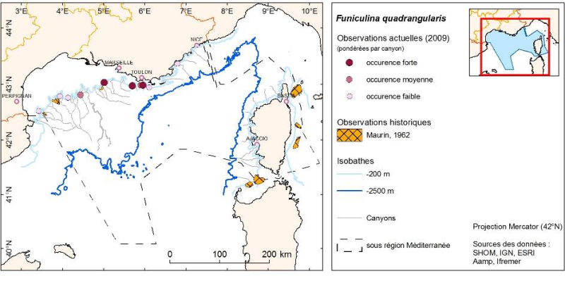
  • Density (number per km²) and biomass (g per km²) of Funiculina quadrangularis (Pennatulacea) and Isidella elongata (Alcyonacea) observed in bottom trawl scientific surveys (French MEDITS and NOURMED) by-catches from 2012 to 2019

  • Location distribution per grid cell of 8 harbor seals (Phoca vitulina), followed by Fastloc GPS / GSM tags from the bay of Mont Saint-Michel from 2006 to 2008