 Mon GéoSource
Sète
Type of resources
Available actions
Topics
INSPIRE themes
Keywords
Contact for the resource
Provided by
Years
Formats
Representation types
Update frequencies
status
Scale
Resolution
-
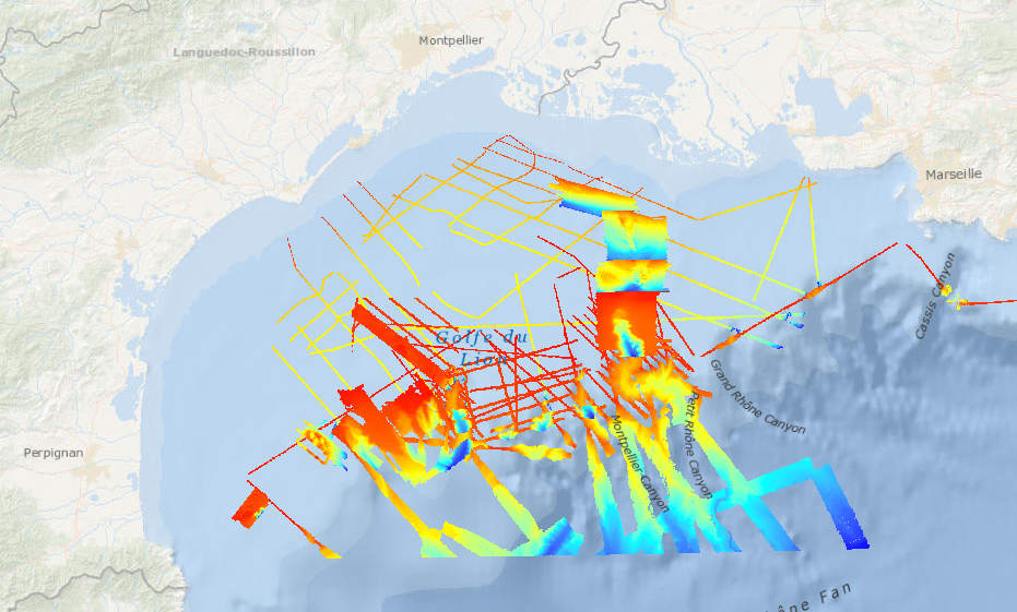
Ce lot de données bathymétriques est mis à disposition dans le cadre de l'étude de dérisquage à réaliser dans le Golfe du Lion pour l'attribution d'un Appel d'Offre "éolien flottant commercial" d'ici 2022. Il regroupe des modèles numériques de bathymétrie couvrant uniquement les eaux territoriales françaises, et dont les données ont été acquises pendant les campagnes océanographiques : AM-MED-1, BASAR2, BASAR3, RHOSOS et STRATAFORM 1.
-
Data were extracted from videos recorded during MEDSEACAN_2009 and CORSEACAN_2010 cruises operated by Comex (Aamp funding). Underwater vehicles were either Achille ROV or Remora submersible. Video analyses were realized by Ifremer and GIS posidonie.
-
Data were extracted from videos recorded during MEDSEACAN_2009 and CORSEACAN_2010 cruises operated by Comex (Aamp funding). Underwater vehicles were either Achille ROV or Remora submersible. Video analyses were realized by Ifremer and GIS posidonie.
-
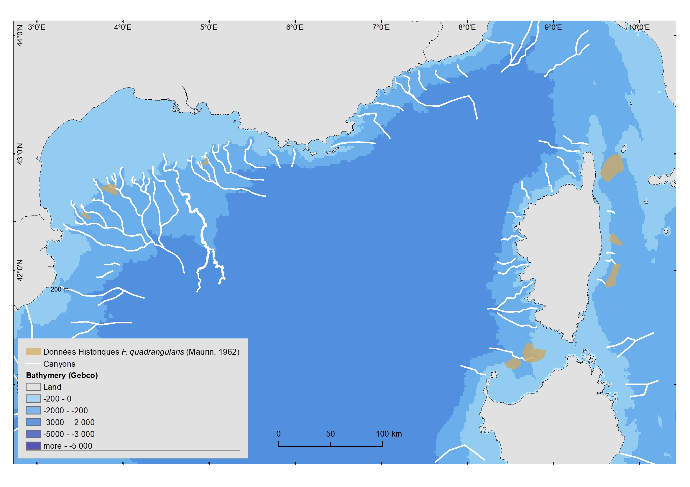
The distribution of the Vulnerable Marine Ecosystem Funiculina quadrangularis (Pennatulacea) was digitalized from a document edited in 1962 (Maurin, 1962).
-

Structures Géologiques Particulières du large (Côtes Méditerranéennes françaises), recensement effectué pour les besoins de la DCSMM, Descripteur D1-Biodiversité des habitats benthiques profonds. Cette couche localise les structures sur lesquelles des communautés spécifiques peuvent s'installer.
-
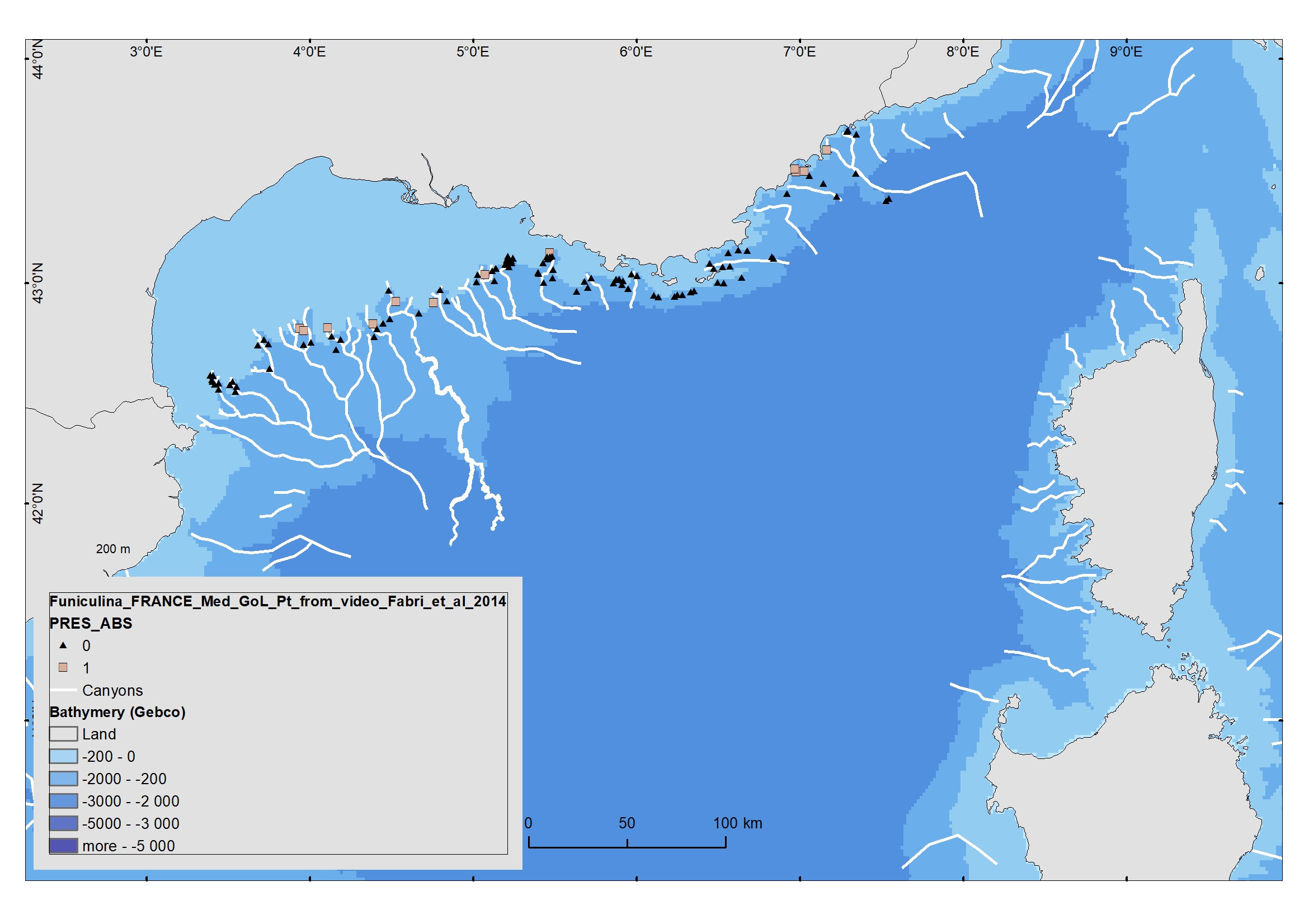
Soft mud facies with Funiculina quadrangularis is an essential habitat for certain crustacean species (Parapenaeus longirostris and Nephrops norvegicus). These habitats are potentially vulnerable as they are targeted by fisheries. These VME fauna seem to have been swept away by repeated trawling. Vulnerable Marine Ecosystems (VME) in the deep Mediterranean Sea have been identified by the General Fisheries Commission for the Mediterranean as consisting of communities of Scleractinia (Lophelia pertusa and Madrepora oculata), Pennatulacea (Funiculina quadrangularis) and Alcyonacea (Isidella elongata). This dataset concerns video data recorded in the heads of French Mediterranean canyons. Quantitative observations were extracted from 101 video films recorded during the MEDSEACAN cruise in 2009 (Aamp/Comex), in addition to 12 Ifremer dives. Species recognized in the video films were recorded from 180 to 700 m depth, and were mapped using GIS. Funiculina quadrangularis was rarely observed, being confined for the most part to the Marti canyon (Hérault). This dataset is linked to the pulication Fabri et al, 2014. https://doi.org/10.1016/j.dsr2.2013.06.016
-
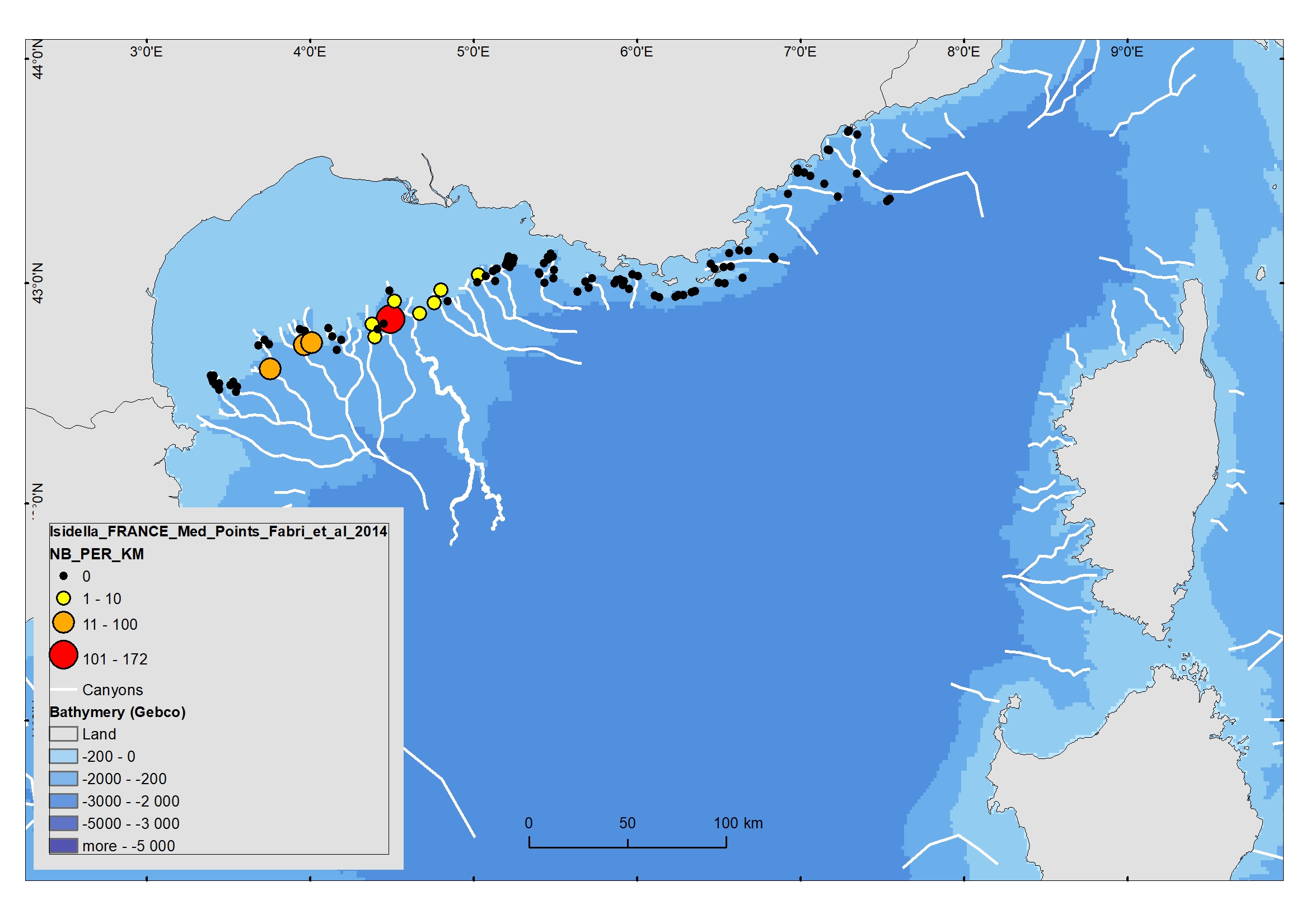
Compact mud facies with Isidella elongata is a relevant habitat for red shrimps (Aristeus antennatus and Aristaeomorpha foliacea). These habitats are potentially vulnerable as they are targeted by fisheries.These VME fauna seem to have been swept away by repeated trawling. Vulnerable Marine Ecosystems (VME) in the deep Mediterranean Sea have been identified by the General Fisheries Commission for the Mediterranean as consisting of communities of Scleractinia (Lophelia pertusa and Madrepora oculata), Pennatulacea (Funiculina quadrangularis) and Alcyonacea (Isidella elongata). This dataset concerns video data recorded in the heads of French Mediterranean canyons. Quantitative observations were extracted from 101 video films recorded during the MEDSEACAN cruise in 2009 (Aamp/Comex), in addition to 12 Ifremer dives. Species recognized in the video films were recorded from 180 to 700 m depth, and were mapped using GIS. Isidella elongata was abundant in three canyons of the Gulf of Lion (Bourcart, Marti, Petit-Rhône). This dataset is linked to the pulication Fabri et al, 2014. https://doi.org/10.1016/j.dsr2.2013.06.016
-
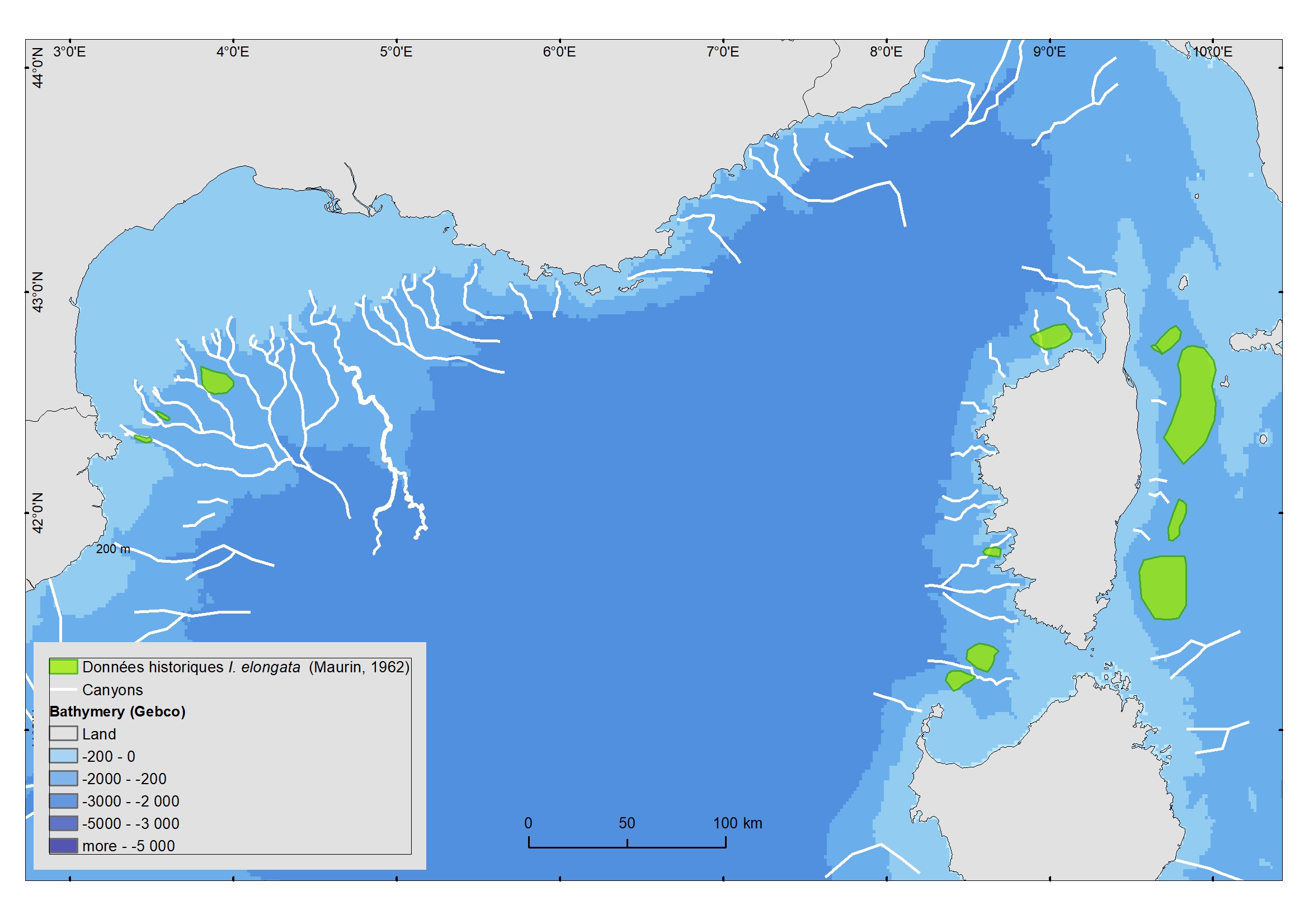
The distribution of the Vulnerable Marine Ecosystem Isidella elongata (Alcyonacea) was digitalized from a document edited in 1962 (Maurin, 1962).
-

L'espace maritime français, d’une surface totale d’environ 10,2 millions de km² hors plateau juridique continental étendu (et de 10,8 millions de km² avec plateau juridique continental étendu), représente le deuxième espace maritime mondial derrière celui des États-Unis d'Amérique. Les Outre-mer correspondent à près de 96 % à ces espaces. Ce produit a pour principal intérêt de fermer l'espace maritime français sur la base des délimitations maritimes françaises officielles (Shom, 2021) et de différentes limites terre-mer. Il est fourni à titre indicatif, seules les délimitations maritimes françaises étant juridiquement opposables. Des associations ont été faites par ailleurs au niveau des attributs afin d'associer les espaces maritimes à différents libellés ou codes officiels en vigueur (IHO, ISO, INSEE, NUTS, FAO).
-
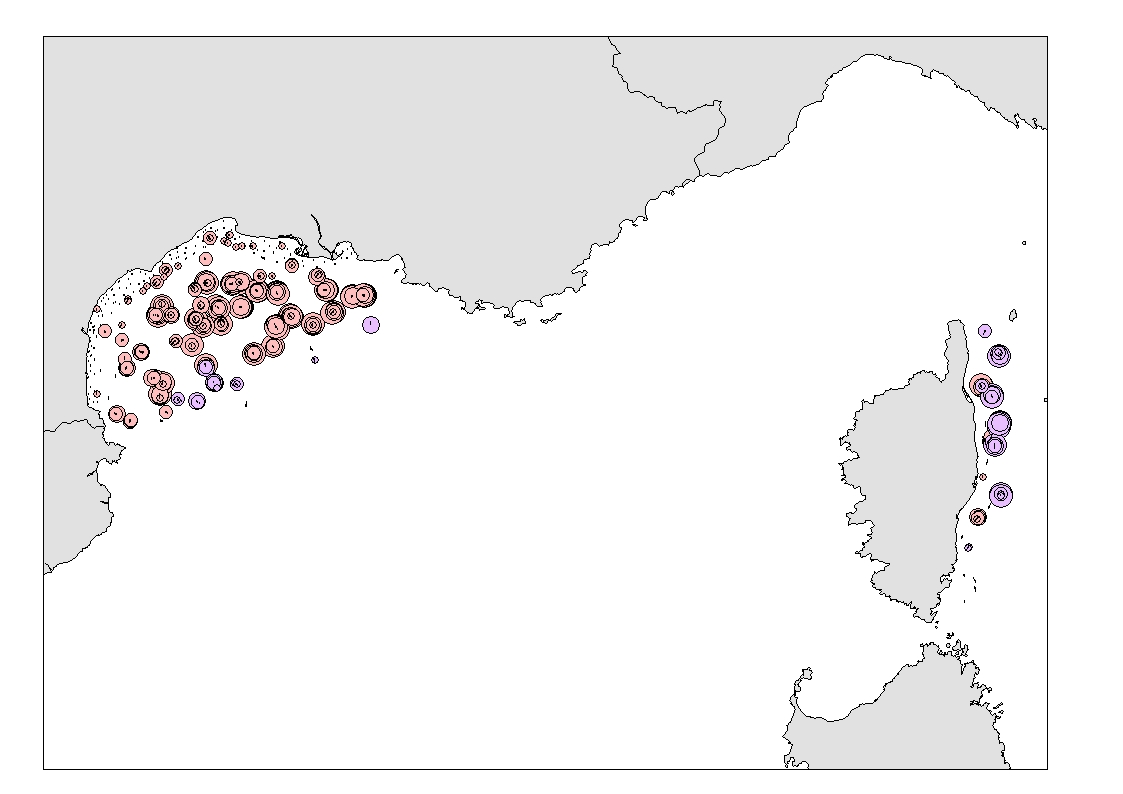
Densité (nombre par km²) et biomasse (g par km²) des captures accessoires de Funiculina quadrangularis (Pennatulacea) et Isidella elongata (Alcyonacea) observées lors des campagnes scientifiques de chalutage de fond (MEDITS partie française et NOURMED) de 2012 à 2019